
Mr Hamhead


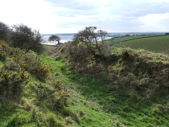
Black Head juts out into St Austell bay on its west side. Very little remains of any antiquity except two high banks and one deep ditch on the east side of the istmus.
The headland can be reached via the SWCP from a car park at Trenarren, but it is still at least half a mile away...great views on a good day!


The main ditch on the eastern side of the narrow neck...a good 20 ft deep I would think. St Austell bay in the distance....Chez Hamhead in the very far distance!

Having been asked by Chris to go and see what i thought, I duly obliged. Despite the fact that Chris had warned me about the confusion over footpaths I still went wrong! Parked on bend by telephone box just north of Penhal Vean. Footpath leads past a couple of farms and a flooded pit (nature reserve?)before splitting. Take the left hand side path, that helpfully isnt signposted but heads up through a gateway. Follow the left side hedge as it bends to the left going over a stile in a wire fence along the way.
The stone is hidden right up to the point you see it.
Like Chris I am still not totally convinced...but why should it not be? Why erect a huge lump like this for a gatepost when there are loads of other stones around that would have done just as good a job but without the effort?
Ocifant..your views next please.

View from the hedge...looking along top of stone..just for the hell of it!

..marks a gateway...but no evidence of there ever having been anything attached to the stone. Many other large stones lying around, especially in wall at top of field (just seen to right of stone)


The jewel in the crown of this area. Not only is this a wondeful example of a cist but the wall of stones around it just make it all perfect...and all this with the backdrop of Kilmar Tor.
It can be found on the south (left) side of the track leading to the farm. Head upslope just before reaching the farm gate, the cairn is about level with the change of direction with the field wall.
I did not test how deep the cist was as it was full of water but it is fair to say it is compact in size.


Not a true quoit as in those at Trethevy, Zennor, Lanyon or Chun but more in keeping with the one at Leskernick.
The cap stone sits balanced on one boulder and one very large rock. From the wetern end it looks as if the base has been cut away to allow space...or was it chosen because of this feature?
I will endevour to find out more about this stone setting.
Found upslope of the Twelve Men’s cairn this wonderful lump sits proud on its base just as if someone had sited it there.


Easily found on the left beside the track to the farm shortly after leaving the wall on the right. The cairn itself is in a ruinous state but the lovely little cist sits snuggled under a low earth bank.

In theory Twelve Men’s Moor covers a large area to the north of Minions from Sharp Tor to Hawk’s Tor. Its name supposedly came about when the land, owned by the Priory of Launceston, was divided up between 12 tenants in 1284. As several sites in this large area are already posted then I will use this site to feature those that lie to the north of Kilmar Tor and south of Trewortha and Hawk’s Tor.
The easiest way to reach this area is by taking the minor road off the B3254 at Berriobridge.
Be careful on this minor raod as there are several large humps.
A parking space can be found at the top of the road where a gate leads onto the track to Trewortha farm.
I am sure there are plenty of other antiquities on this wonderful archive...it is just that I was researching this particular spot..
No sign of the stone row mentioned in an earlier posting..

One of the many hut circles to be found on the hill. This photo does not do justice to the stonework on the far side.
The most northerly of the interesting features on the hill, the summit cairn is a jumbled assortment of rocks with one stone standing proud.


Lovely stone wall on the west side of the hill...one of the many that cover this fascinating area.


Looking towards Brown Willy, the four southern stones do not at first appear to be in a circle...believe me they are.
I was shown this circle a month or so ago whilst on a walk with the Cornish Archealogical Society. At the time there were too many people milling about to get a good photo so another trip out onto the moor was called for. It has only been ‘discovered’ in the last year or so when archeologists returning from Leskernick decided to take a different route.
In all there are seven stones still in place, all recumbent, making up perhaps a third of the circle.
It takes a little bit of finding but is easiest reached from Westmoorgate (take the road from Trewint on A30). Go through gate onto moor and cross ford. Head north climbing slightly keeping the wall on your right. There are stones all over the place just to make life difficult and several ‘standing’ ones on the crest of the hill..this is not the circle. You will find it before you reach the crest near some earthworks that are almost certain to be the result of mineral prospecting.
This part of the moor is quite featurless...do not venture out onto it if cloud is low or it is misty.

Looking towards the fort from further inland. The photo clearly shows the plateau at the centre of the view.
Reached by a road running northwest from the beacon and then taking a path across a field on the left. Keep to hedge to far end and go over stile...the fort is infront of you.
A large ditch and banks seperates field from a flat area that then drops away into the valley. This is an unusual site and thought to be Iron Age in date. It is in a great setting and would be easy to protect from all sides.
Superb views out to sea.
What a stonker!
Easily found if you have an OS map and only about half a mile from Veryan village if you walk. Who knows what uses this barrow has had over the years..I would guess the concrete slab on the top was a lookout post as the views are superb...even on a windy day in March.
Rabbits are busy colonising the barrow and I had a good look around to see if any of the Golden Ship had been dug out by them...
The nearby Ringarounds are worth a visit if you have time...if just for the strange design of the ‘fort’ and the view.

Hadn’t intended to visit the circles on Sunday afternoon but as I drove up towards Minions village a thin layer of mist formed just above the surface of the moor.
By the time I got out to the circle light was fading fast and proping myself against a stone I tried my hardest to capture the atmosphere with out too much blur..this is the best attempt.

Two cairns sit on this little visited stretch of Moorland that covers the high ground to the west of the Fowey River. Both have been dug into and now resemble overgrown mounds, the southern most one being covered in Gorse bushes.
I would not recommend making a special trip to see these..not with so much else to see on the moor.
Flyingpast.org is the culmination of a twelve year project mapping archaeological and historical sites visible on aerial photos in Cornwall and the Isles of Scilly. The project was commissioned and paid for by English Heritage and the mapping was carried out by the Historic Environment Service of Cornwall County Council. That’s their words...my words...brilliant site!

Notice no centre stone, a later addition and I believe a boundry marker.
Also he says that the stones average three feet above ground...which makes those two gents about 4 ft tall!
Image credit: JT Blight 1858

Not sure where this ‘quoit’ was. Image is taken from Blights ‘Ancient Crosses and other Antiquaries in East Cornwall’ but I can not find the text to link with the image.
Image credit: JT Blight 1858

Published in ‘Ancient Crosses and other Antiquities in East Cornwall‘
Find it on Google Books...free to download
Image credit: JT Blight 1858

