Not the easiest site to find if approaching from above...so....walking north along Drift Lane from Postbridge look out for a stile on the left as you start to climb out onto the open moor. Once over the stile keep going till you reach a dry ditch (the Powder Mill leat) Turn right and follow this to the first tree. The turn uphill for about 50 yards and you just might find it....
Mr Hamhead

Looking north with tree marked to aid direction.
P.s. the arrow is no longer there...
Not the easiest site to find....walking north along Drift Lane from Postbridge look out for a stile on the left as you start to climb out onto the open moor. Once over the stile keep going till you reach a dry ditch (the Powder Mill leat) Turn right and follow this to the first tree. Then turn uphill for about 50 yards and you just might find it....


Latest photos of work carried out by Cornwall Arch Society in August 09
Kelly’s Directory of Cornwall 1926
Davidstow
......On the Bodmin Moors, near the village is a group of barrows surrounded by well defined moat filled with water, and also a genuine long barrow measuring 170 ft long and 60 feet wide; the burial chamber is at the east end and there are the remains of a fine chromlech. The capstone is huge, 18ft by 7ft, and is composed of igneous rock not found nearer than a mile, so that prehistoric man must have dragged it at least that distance. There are 18 cup markings, a very rare feature, as there is only one other example in Cornwall, in the parish of St Keverne.

Information sheet beside the stones in North Cornwall Museum.

The two stones pictured can now be found in North Cornwall Museum at Camelford. They were taken there in 2008 after spending time at a locals school. They had originally been excavated at Starapark in the 1950s where they made up part of the kerb of the barrow. It is thought there were more than the two stones originally but the others have been lost or destroyed.
The two stones are rare examples of cup marked stones in Cornwall and do not have any recognisable pattern.


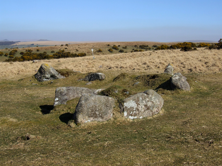
These five uprights have been wedged into a natural fault in the rock at the western end of Hawks Tor. They provide a barrier from anything approaching along the ridge from the west as you either have to climb over them or descend down some distance and traverse around below.
I can find no mention of them in any history books so have no idea what age they belong to..but see no reason why anyone would put them there in ‘modern times’.
Hawks Tor can be accessed from a footpath that heads left from the road up to Trewortha Farm from Berriobridge.


The western tip of the island, where the stone once stood. The sea here was a maelstrom of waves and must have been a terrifying place for prehistoric man. The view west looks out through a channel south of Mull and north of the mainland.

Looking towards the summit of Ben More (left of centre) This was the best view we had of it all day...conditions on the summit had been blizzard like when we got there with a good covering of snow.

9 May 2009
Small and lonely hut circle found whilst descending from Ben More. Too shattered and wet to do much investigating but there did not look to be any other circles in the area.
To find it take path from road on waters edge up past house and through gate. The circle is probably about 11 o’clock from the gate...sorry cant be any clearer!

On Mull to climb mountains and drink....not go looking at stones. Still, we had a few hours before the ferry back so I managed to convince my fellow travellers to take the road from Tobermory to Dervaig to see these monsters.
A parking space with viewpoint out over the sea to Tiree and Coll gives access to the stones. The sign confused me at first, I thought it meant it was a 1.7 km walk to the stones....but looking back I think thats how far it was to toilets. I think I would have disappeared behind a tree before then.....
Anyway, a short walk across some rather boggy grassland leads to the gate into the plantation and there you are. It is interesting to compare the photo in THA with how things are now...the trees have grown somewhat...when will they be felled and the stones returned to there rightful place overlooking the bay?
Somewhere I read that they line up with the hill to the south...hard to say with the trees all around....perhaps soon we will find out.

Confusing sign at car park...the stones are not 1.7 kms away, just a short stroll into the plantation

The northern stone....this would have been some row when all the stones were standing.

Crossing writes in his Guide to Dartmoor that the cairn got its name after a baby was found on Stall Moor and adopted by local people. He was given the name Hillson and after a while moved up onto the hill and built himself a house amongst the stones of the cairn. Here he made a living making clocks...out of what it doesn’t say, but it does say that a Mr Hillson who lived in Cornwood in the mid 1800s had one of these clocks.

Hillsons House...built from the stones of the main cairn on Stalldown, the wall nearest the camera is a modern addition as Crossing only mentions three walls when he visited in the late 1800s.
As can be seen from the images posted there are several cairns in the vicinity of the Stalldown Row...the trouble is, the row is so mighty that the cairns are insignificant in the scope of things!
Usually i would take my time to search them all out but i was just so enthralled with the light playing on the stone row that I only photographed one....sorry!

Cairn just west of summit of stone row, not easily spotted in dead grass. SX633625
Having visited this area about three years ago..or was it four? I decided it was time to return. Last time, after walking up the east side of the Erme, I had decided against the climb up onto Stalldown whilst heading back down the west side and so missed this mighty stone row.
This time I chose a route starting on the west side of the Erme, crossing Harford Bridge and taking a path along the river that soon petered out into several animal tracks and nothing else. Going ‘off piste’ I found my way to Tristis Rock then picking up the stone row directly behind it crossed the moorland northwards to Stalldown.
It is this route that Crossing suggests in his Guide To Dartmoor, Excursion 33 but I have to say the route from Torr along the waterworks track may be easier!
Reaching Stalldown you can not see the row and must head off in a northwesterly direction uphill. You find yourself on a spur of the main ridge and at last get a view of the row ahead and over to the left. It is still a bit of a walk across boggy moorland to reach the southern end of the row, but once there all that remains is to follow its majestic stones to the summit and beyond.
There are a number of small low cairns to be seen along the rows length, but the main one, which gives the hill its name is across the plateau to the east.


Looking south west towards Plymouth Sound from the highest point of the row.


In yesterdays Western Morning News...


March 20th 2009
At last, after being stuck inside during several days of sunshine I get a chance to leave the office and escape onto the moors. Having dropped my father at the hospital on the outskirts of Plymouth I ventured a short distance onto the south west edge of Dartmoor.
Saddlesborough seemed the easiest place to access and having parked the car at the little junction where the lane from Shaugh Prior meets the road going to Cadover Bridge I walked the short distance to the cross beside the road.
Crossing the road here it is not long before you reach a tumuli, a grass covered mound of stones with one large stone sitting just off the mound.
A quick photo and then I headed uphill to where I could already make out the star topped post. Between tumuli and post I thought I might have discovered a circle of stones, all recumbent but creating at least three quarters of a circle about 18 meters across..
As Pure Joy has said before, there are so many stones, it is easy for the mind to imagine things...
The Stone Row when I reached it had recently been cleared of any long grass or gorse and so my walk along it was easily traced. Plunging downhill it ends just before the waste tip of the nearby china clay pit. There is no evidence to suggest it ever went further, but one does wonder.
From the bottom of the row I headed east to discover the hut circles and enclosures lying along the north facing slope of the hill.

A short distance from the road, bare of bracken in the early spring sunshine, looking north.

The same circle, looking south towards Plymouth Sound.
Is this the cairn circle? It is the only ‘circle’ in line with the row, although a little away from the end stone, beside the star post in the distance. I am still a little unsure..it could easily be a hut circle.

From atop of the waste tip you get a great view of the row running up the hill to the star post.

The end of the row...as far as we know. Did it ever continue under the waste tips?