pure joy

pure joy

All posts expand_more 401-450 of 1,015 posts

Miscellaneous

Norsebury Ring
Hillfort

The excellent ‘Hampshire Treasures’ resource gives the following information – “Norsebury Ring. Immediately north of Stoke Charity. Univailate earthwork. Damaged by plough. O.S.A. No. SU44 SE19. Ref: 1. A.S.P. ALG 91. (St. Joseph). Ref: 2. History of Micheldever, 1924, (Milner). Ref: 3. Archaeology of Wessex, 1948 (Grinsell), p.180.” It is a scheduled ancient monument, No.131.

Just to the East (around SU497391) lies the site of the ‘Weston Colley Group’ of 13 round barrows. The ‘Hampshire Treasures’ resource says they have been extensively ploughed out and are now crop marks only.

Latest news on ’Cornish barrow for sale’

Following my enquiry about the ‘Cornish barrow for sale’, I had a pleasant surprise yesterday. A fax from Nic Potter (the present owner).

Avid Kernow-ite TMA’ers may remember that I offered £10,000 for the barrow and land (including some sort of not-for-profit sell on clause), or suggested that maybe the National Trust (or similar organisation) might be worth speaking to, given the general location (Land’s End) and the historic interest.

Nic is selling some moor land (just less than 4 acres) in Penwith which includes a recently discovered ‘double ringed’ barrow. The land can’t be farmed or built upon.

The fax said that following the press/media coverage the website received over 11,000 hits and Nic has decided that it will be easiest to sell it at auction, via FPD Savills (Tel – 020 7824 9091), on 22nd September 2003 in London (I’m a bit confused about the venue – website says something different to Nic’s fax). A small amount of information can be found here – https://195.224.227.45/fpdsavills/

Nic says that it has proved, due to its uniqueness, impossible to value it (there simply is no precedent). Therefore there will be no estimate or guide price, but there will be a reserve, which Nic cannot reveal.

Nic added that frankly it could go for a low, medium or high price – he simply doesn’t know what will happen. He’s selling the land to provide funds for a recording studio. He liked the spirit of my offer, and added that if I couldn’t put in a higher bid, he’d talk to me if it remained unsold.

Miscellaneous

Hayes Common Earthworks
Ancient Village / Settlement / Misc. Earthwork

There are two separate earthwork areas marked on the OS map. One is on the far Western part of the Common, centred on TQ398652. This looks close to circular. The other area is about one kilometre to the East, where two linear earthworks are shown around TQ408652. The western one crosses the road and looks about 400m long (aligned NNE – SSW). The Eastern looks shorter, maybe 250m, and aligned closer to North – South.

‘Prehistoric London’ by Nick Merriman (1990 – ISBN 0112904475) mentions that “…the places where people lived in this early part of the ‘Bronze Age’ are very difficult to find. Within the Greater London area, most sites are limited to isolated pits, which contain pottery, flints and occasionally loomweights, or quernstones for grinding grain. Sometimes pits are clay-lined for storing grain or water. Examples of these settlement areas have been found on Hayes Common near Bromley and at Sipson in Hillingdon, where loomweights attest some of the earliest weaving known in London.” Later on he comments “Sometimes it is possible to find traces of the fields which surrounded these settlements, in which crops were grown or animals grazed. At Hayes Common and near Runnymede, large ditches have been found which probably acted both as property boundaries and as drainage ditches for the fields.

Stanwell Enclosure

This one may or may not be pre-Christian. I haven’t found much out about it yet, but I did visit it today, so at least I know a little about it.

Whilst reading books and looking at maps I came across the word ‘Enclosure’ on the 1:50,000 map, but no indication of where it actually was. The 1:25,000 map has no such word, but does have two possible sites.

The site that looked promising was a big banana shaped earthwork type thing centred on TQ052747. In reality, this is a huge modern concrete thing inside the perimeter fence of Heathrow Airport (presumably it’s some sort of sound shield or safety device).

The other one proved to be far more interesting, centred on TQ056746. After thinking at first that it might be on private land, I’m now pretty sure it is not. Part of the land off Oaks Road (near ‘The Rising Sun’) does have wire all around it and lots of signs saying ‘British Airports – Private property – No Trespassing’, but the bit that the enclosure lies on is presumably open land, as there are seats dotted around, a few scabby picnic tables, and two official steel entrances, one on the north east side near the Southern Perimeter Road at about TQ058746, and one on the south side at the corner of Russell Drive and Oaks Rd at about TQ057744. But there are no signs to say anything about the land.

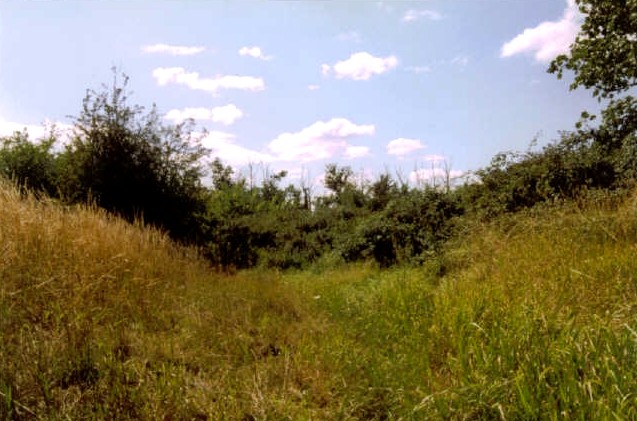
The enclosure is basically a decent sized ditch, pretty much overgrown with brambles and trees, but relatively impressive considering is few metres from Heathrow! Varies in size but mainly about 3 metres across and a metre deep.

I can’t find any info about it in “The Archaeology of Hounslow” by Gillian Clegg (1991 – ISBN 0951831901), or “Prehistoric London” by Nick Merriman (1990 – ISBN 0112904475), which worries me. Anyone else know about it?

Miscellaneous

Mayfield Farm Enclosure
Enclosure

I read about this site in ‘The Archaeology of Hounslow’ by Gillian Clegg (1991 – ISBN 0951831901) which says “A small henge monument dating to the Neolithic period was found during excavations at Mayfield Farm in East Bedfont.” Later the book continues “On the same site as the Neolithic henge monument but some distance away, two concentric ditches which had shown up in aerial photographs proved to be a double ditched enclosure dating to the late bronze Age. A substantially defended settlement, it must have dominated this part of the Thames Valley. It may have been an important regional center controlling a large territory, perhaps including the waterside settlement at Brantford and the similar and important Bronze Age waterside settlements at Runnymede/Egham, only three or four miles away.” Later still the book adds that “Occupation on the Site at Mayfield Farm in East Bedfont…continued into the Iron Age. Gulleys found probably surrounded circular huts, and pits nearby were probably dug for the extraction of gravel.”

‘Prehistoric London’ by Nick Merriman (1990 – ISBN 0112904475) says this “Another, even larger, site has recently been identified by aerial photography at Mayfield Farm just to the South of Heathrow Airport, and 6.5kms away from Runnymede. It consists of two concentric ditches with a maximum diameter of 200m enclosing an area of 3.14 hectares (7.75 acres), and trial trenches cut into it reveal its date as some time in the Late Bronze Age (1200 – 700 BC). It is the largest such enclosure of this period in the Lower Thames valley, and if it is fully excavated it may prove to have been a very important regional center which controlled a large territory.”

Mayfield Farm Enclosure

I am very chuffed about finding this ‘site’ today. However, there is nothing to see on the ground, but it does show up from aerial pics, so if you are landing at Heathrow in the usual way (most planes land from an Easterly direction) get a window seat on the left of the plane and have a look down to your left, just before landing and it might be visible just to the south of Terminal Four – I guess you probably won’t see it though as the angle might not be right, and I’m led to believe that in general crop marks only show up clearly in the right conditions.

After finding out about it from books (which didn’t say exactly where it was) and only having a vague idea of where it was, and two aerial photos of the Bronze Age Enclosure, I did a bit of map detective work and decided that I thought I knew where it was, alongside the A30 between Terminal 4 at Heathrow Airport and the Clock House Roundabout (A30 / A315). And I was pretty sure on the ground that I was in the right place, a large field with some sort pea / legume crop, that I hadn’t seen before, growing in it. Nothing can be seen on the ground although the area of the grid ref given for this site is definitely raised a bit compared to the surrounding land.

The books said it was part of ‘Mayfield Farm’ in Bedfont (which wasn’t named on the map) so as a final check I walked around to the other part of the A30 and yes indeed, this is definitely the right place – the farm buildings for Mayfield Farm are at TQ075733.

With a Neolithic henge also found on the farmland, this is one very important site despite the lack of visual impact!

The Negen Stones

(site of) The Negen Stones – 27.7.2003

Not much I can add. ‘Jimgoddard’ has obviously done his homework!! Like many of the important sites on the fringe of Greater London there is nothing to see at the ‘site’ (unlike you really like busy roundabouts)

Just to say that if you want a nice short walk and a decent place to park (if you can avoid the ‘Private Road’, ‘No Parking’, ‘I have a Big house’ etc signs that pervade the area), drive a few hundred metres down the A320 (Chertsey Lane, which by the by takes you to St Ann’s Hill Fort within about 5 minutes) and take the first left into the side streets. Walk back to the site of the Negen Stones, and then wander along the river and back up to where you parked. ‘The Hythe’ (mentioned by ‘Jimgoddard’) is the lane parallel to the river, starting from the bridge, and has a pub. The riverbank has a pub as well, so a short walk could be turned into a long session – hic!

St Ann’s Hill

St.Ann’s Hill Fort (aka Eldebury [Oldbury] Hill Fort) – 27.7.2003

As Juamei said, not the most evocative Hill Fort in Britain, but a pleasant walk if you can try to forget the constant hum of the traffic from the nearby (but unseen) M ways. The whole of the open area covers 57 acres in all.

The info board gives a tiny bit of info on the hill “St.Ann’s Hill takes its name form a chapel built around 1334 dedicated to St.Ann. Its original name was Eldebury (Oldbury) Hill with an old fort, and there are traces of old earthen defences on the top. The most notable resident of the Hill was the radical politician Charles Fox whose house was opposite the present main entrance. The hill was presented to the Local Authority by Baron Camrose of Longcross and opened by the Rt.Hon. Neville Chamberlain MP in June 1928”.

The ramparts are not particularly strongly preserved. Best on the west side. Also strong on the East side but the track up to the Reservoir Cottage (at the top of the hill) makes them look a bit false.

NB – The roads towards the hill are signposted to a point but overgrown at the crucial turnoff onto ‘St.Anns Hill Rd’ so look for the road sign of that name.

Miscellaneous

Tatchbury Mount
Hillfort

The excellent ‘Hampshire Treasures’ resource gives the following information – “Multivallate Hill Fort. Tatchbury Mount Hospital. Area built over by hospital buildings but outline can still be seen. O.S.A. No. SU31 SW1”

Miscellaneous

Bokerley Dyke
Dyke

The excellent ‘Hampshire Treasures’ resource suggests that only a small part of this exists in this area, but more exists if you go south east. If you follow the map west even the ‘course of’ peters out pretty quickly (unlike the nearby Grim’s Ditch). The resource says “Celtic Field Boundary Lines – SU036197 – Iron Age – North east of Bokerley Gap. Ditch 10.0 m. in width. Only 300 m. now survive” – then it gives more info elsewhere “Bokerley Dyke. SU032198. Scheduled Ancient Monumnet, no.261. A defensive work. Bears a close resemblance to Grim’s Ditch but is of modest dimensions in this area, until it reaches Blagdon Hill.”

Blagdon Hill is presumably the Hill around SU055176 (2-3km to the south West)

Miscellaneous

Tidpit Common Down
Long Barrow

In the absence of any other name I can find I’ve given it this name. This isn’t marked on the OS map but is logged on the fantastic ‘Hampshire Treasures’ resource – “Long Barrow – Tidpit Common Down. 30 m. long and 20 m. wide with a height of 1 m. No visible side ditches. O.S.A. No. SU01 NE12. Ref: P.H.F.C., Vol. 14, 1938, (Grinsell), pp. 195, 203.”

Miscellaneous

Long Barrow Lane
Long Barrow

In the absence of any other name I can find I’ve given it this name. The fantastic ‘Hampshire Treasures’ resource gives the following info – “Long Barrow Lane. Very mutilated, no regular shape. Varies from 37 m. to 40 m. long and is approximately 9 m. wide. Much overgrown. O.S.A. No. SU02 SE23.”

Miscellaneous

Vernditch Chase
Long Barrow

The fantastic ‘Hampshire Treasures’ resource gives the following info on this scheduled ancient monument, no.430 – “ 135 yds. north of the Roman road, on the Hants/ Wilts border. 38 m. long by 24 m. wide. Ditch visible on west side with only vague traces on the east side O.S.A. No. SU02 SW34.”

The OS map shows another Long barrow in Vernditch Chase about a 1km due North, but I can’t find any information about that one!

Miscellaneous

Sarsen Stone (Martin)
Standing Stone / Menhir

I thought I’d dig out what information the excellent ‘Hampshire Treasures’ resource gives on this stone. They have it under natural features – “Sarsen Stone No. 47A – County boundary – ancient track junction. One example of sandstone boulders dating from prehistoric times, which were often used in olden days for religious purposes and also served as boundary marks in ancient fields. Ref: 1. The Kennet Valley Sarsen Industry, Wiltshire Archaeological Magazine 63, 1968, pp.83-93. Ref: 2. P.H.F.C., Vol. 2, Nos. 9 and 10, p.116.”

Miscellaneous

The Butts (New Forest)
Barrow / Cairn Cemetery

Barrow cemetery of five bowl barrows on the edge of a large plain. The excellent ‘Hampshire Treasures’ resource gives the following information – “The Butts. A – 15.0 m diameter and 0.9 m high. Mutilated by a trench. B – 11.0 m diameter and 0.8 m high. Mutilated. C – 10.5 m diameter and 0.6 m high. D – 16.5 m diameter and 1.2 m high. Depression in centre. E – 15.0 m northeast of barrow D. Low heather covered mound approx 9.0 m diameter and 0.5 m high. Hollow in centre. No visible ditch. O.S.A No. SU21 NW7. Ref: P.H.F.C., Vol. 14, 1935, (Grinsell), p.357.”

Roman pottery kilns were located just 400 m south in Island Thorns lnclosure (at SU215152) which manufactured and widely distributed a large variety of New Forest ware in the 3rd and 4th centuries. Later Romano-British pottery kilns were located further south at Crock Hill (at SU214144).

Miscellaneous

Lower Exbury
Promontory Fort

A rare example of a fort on a river estuary, in a great position where the River Beaulieu kinks sharply. Officially the period is unknown but it is suspected to be Iron Age. The excellent ‘Hampshire Treasures’ resource gives the following information – “Defended on the west by the River Beaulieu and on east by a bank and outer ditch. O.S.A. No. SZ49 NW3. Ref: Ancient Earthworks in the New Forest, 1917, (Sumner), p.119.”

Miscellaneous

lbsley Common
Round Barrow(s)

The excellent ‘Hampshire Treasures’ resource gives the following information on several sites on this common.

A barrow cemetery of six barrows centred on SU174105.

Two Bowl barrows that form a scheduled ancient monument, no.306. One is at SU181112 – “11 m diameter and 0.6 m high. Heather covered”, the other at SU181109 – “10 m diameter and approximately 2.3 m high.”

The sites of Bowl Barrows at SU167099 that form the scheduled ancient monument, no. 293. “South east of Newtown. An in-urned cremation of an adult female found in the centre of one barrow.”

Miscellaneous

The Butt (Fritham)
Round Barrow(s)

One of the larget bowl barrows in the New Forest area, and now a scheduled ancient monument, no.298. The excellent ‘Hampshire Treasures’ resource gives the following information – “The Butt, Fritham. Measures 23.5m. in diameter and 2.2m. in height. Surrounded by a ditch. Mutilated on top by a brick structure. O.S.A. SU21 SW19 Ref: P.H.F.C., Vol. 14, 1938-40, p.358.”

Miscellaneous

Stagsbury Hill
Barrow / Cairn Cemetery

Seven barrows make up this cemetery which is a scheduled ancient monument, no.280. The excellent ‘Hampshire Treasures’ resource gives the following information – “Stagsbury Hill. Area covered with gorse and heather. A – Large ditched bell barrow. 32.0m diameter and 1.2m high. B – Bowl Barrow, 15.0m diameter and 0.8m high. C – Bowl Barrow, 14.0.m diameter and 0.6m high. D – Bowl Barrow, 9.0m diameter and 0.7m high. Central mutilation. E – Ditched Bowl Barrow, 16.0m diameter and 1.2m high. Central mutilation. F – Bowl Barrow, 16.0m diameter and 0.6m high. G – Bowl Barrow, 15.0m diameter and 0.9m high. Mutilated by hollow-ways on the north side. O.S.A. SU21 NE9. Ref: P.H.F.C., Vol. 14, p.357.”

Miscellaneous

Black Bush Plain
Barrow / Cairn Cemetery

Five Bowl Barrows. The excellent ‘Hampshire Treasures’ resource gives the following information – “Near old gravel workings. A – 7.0m diameter and 0.5m high. No visible ditch. Slight central mutilation. B – 6.0m diameter and 0.3m high. No visible ditch. Mutilated. C – 11.0m diameter and 0.8m high. No visible ditch. D – 8.0m diameter and 0.8m high. No visible ditch. Mutilated. E – 8.5m diameter and 0.5m high. No visible ditch. O.S.A. SU21 NW10. Ref: P.H.F.C., Vol. 14, p.351”

A palaeolithic implement wa sfound nearby at SU250153. “Found in old gravel pit on open forest. Site overgrown with pine trees”

Miscellaneous

South Baddesley Stone
Standing Stone / Menhir

This is intriguing; I wonder if someone local can check it out. The excellent ‘Hampshire Treasures’ resource gives just the following information – “Monolithic Stone – Moved to roadside during road making operations”.

It’s in South Baddesley, which is part of Boldre parish – the “Bouvre” of the Domesday Book (1086). The parish contains evidence of habitation during the Stone Age – implements; Bronze Age – barrows; and in Roman times – coins found at Norley wood.

Miscellaneous

Seven Barrows
Barrow / Cairn Cemetery

I thought I’d dig out what information the excellent ‘Hampshire Treasures’ resource gives on this site – “Thorn Down. Tumulus group consisting of [7] bowl and disc barrows, three of which contained evidence of cremations. Centred on grid reference. O.S.A. No. SU45 NE31. Ref: 1. Proceedings of the Dorset Natural History and Archaeological Society, Vol. 1, 1870, p.197. Ref: 2. P.H.F.C., Vol. 14, 1938-40, pp.206-7.” This is a scheduled ancient monument, no.71.

A Stone Age implement was found at SU463555 – “Litchfield Down. Palaeolithic flint axe found at foot of escarpment. Present whereabouts not known”

Miscellaneous

Castle Piece
Hillfort

The excellent ‘Hampshire Treasures’ resource gives the following information – “CastlePiece. Probable Hill Fort. Earthwork encloses 41/2 acres. Entrenchments are well spread but clearly defined gap in south east side is probably the original entrance. O.S.A. No. SU10 NE18. Ref: 1. Field Archaeology as Illustrated by Hampshire, 1915, (Williams-Freeman), p.170, p.433. Ref: 2. Ancient Earthworks in the New Forest, 1917, (Sumner), p.26.” This is a scheduled ancient monument no.229.

Miscellaneous

North Yew Tree Heath Barrows
Barrow / Cairn Cemetery

10 barrows in a small area form scheduled ancient monument no.249.

The excellent ‘Hampshire Treasures’ resource gives the following information – “SU366080 – North Yew Tree Heath. A group of six bowl barrows and a probable bell barrow. All ditched”.

“Bowl Barrow. SU362082. West of Foxhill Farm. 1.5m in diameter. 0.7m high. Surrounding ditch. Gorse-covered large central mutilation”.

“Bowl Barrow. SU362082. West of Foxhill Farm. 9.0m diameter. 0.8m high. Slight trace of ditch on south side. Heather covered. Large crater mutilation.”

“Barrow. SU366079. North Yew Tree Heath. Probably bowl barrow. To the south of group of seven”

Miscellaneous

Knoll Camp
Hillfort

The excellent ‘Hampshire Treasures’ resource gives the following information – “Knoll Camp. Early hill fort. Circular earthwork containing about four acres. Ditch with inner rampart and traces of counter scarp bank. O.S.A. No. SU01 NE26. Ref: Field Archaeology in Hampshire, 1915, (Williams-Freeman), p.400.” This is a scheduled ancient monument no.118. Grim’s Ditch also runs throughout this area.

The resource also records a probable Iron Age Cross Ridge close-by. “Damerham Knoll, 50m. west of Knoll Camp. Comprises a shallow ditch with fragmentary remains of a bank on the west side. SU098185”

Miscellaneous

Burnt Axon
Round Barrow(s)

The excellent ‘Hampshire Treasures’ resource gives the following information – “Burnt Axon-Church Moor. 13.5m. diameter, 1.3m. high. Surrounded by a ditch. Bracken covered. Much mutilated by rabbits. O.S.A. No. SU10 SE7. Ref: 1. Records of Burley, p.201. Ref: 2. P.H.F.C., Vol. 14, 1938, (Grinsell), p.360.” This is a scheduled ancient monument no.273

Miscellaneous

Castle Hill (Burley Street)
Hillfort

The excellent ‘Hampshire Treasures’ resource gives the following information – “Castle Hill. Univailate hill fort. Encloses an area of about five acres. Surrounded by a single rampart and ditch. Interior overgrown and marshy in places. O.S.A. No. SU10 SE9. Ref: Records of Burley, p.203.” This is a scheduled ancient monument, no.226.

The Parish of Burley probably derives its name from the Saxon “bury” which usually denoted an Iron Age hill fort (in this case Castle Hill).

A commemorative stone apparently stands at Blackbush, Castle Hill Lane (SU199036). Dated 1823. Erected by Thomas Eyre. Inscription reads:- ‘Near this is the remains of a camp or castle either of the ancient Britons, Romans or Saxons, with the Agger. Valium, Fosse, Tumulus or Barrows. Be civil, quiet and useful, 1823’. umm, yeah...whatever.

Miscellaneous

Creek Bottom Barrows
Round Barrow(s)

The excellent ‘Hampshire Treasures’ resource gives the following information – “South of Creek Bottom. A – Bell barrow 151/2m.diameter with a berm on west side, 21/2m. wide. Much mutilated. B – Bowl barrow 16m. diameter and 1.6m. high. Visible ditch. Both barrows. Both barrows excavated 1949. Three stone cists with cremations found.”

The resource also records the remains of a Boiling Mound at SU236028 “Creek Bottom. A concentration of calcined flints and some worked flints have been found.”

Miscellaneous

Holman’s Bottom Barrows
Round Barrow(s)

The excellent ‘Hampshire Treasures’ resource gives the following information – “Holman’s Bottom. Bowl Barrow. 11m.diameter and 0.8m. high. Traces of a ditch. Gorse covered and mutilated by rabbits.”

The OS map marks another barrow just a few hundred metres to the North, but I couldn’t find out anything about this. The map is also intriguingly marked with ‘Naked Man – site of’, just to the east. I wonder what all that is about? The area also contains Scrape Bottom – ouch!

Miscellaneous

Elkham Grave Barrow
Round Barrow(s)

The excellent ‘Hampshire Treasures’ resource gives the following information – “The name Elkham Grave is often given to this area, The site of this barrow is still visible as a low mound, 10.0m. diameter and 0.1m. high. No visible traces of a ditch.”

Mesolithic Flints were found at SZ251985. “Several worked flints found in the gravel pit at the south east corner of Broadley Enclosure.”

The site of another barrow is also reported at SZ253984.

This barrow is in the Parish of Brockenhurst, which was the only village within the Perambulation of the New Forest which was listed in the Domesday survey of 1086 as having a church. St.Nicholas, built upon a mound, may date back to pagan times. Roman “bricks” and parts of second and third century masonry have been built into the south porch and, in the south wall of the nave, typical herringbone masonry, possibly from an earlier church, can be seen. The churchyard contains the grave of the snake catcher Brusher Mills, a famous local character, his headstone being suitably engraved.

Miscellaneous

Giant’s Grave
Long Barrow

The fantastic ‘Hampshire Treasures’ resource gives the following info – “Giants Grave’, Breamore Down . Long Barrow – SU138200 – Originally 65m. long and 26m. wide with flanked ditches. Now partly mutilated. No trace of ditches due to ploughing. Scheduled Ancient Monument no.35” Referred to in Pevnser’s guide to the “Buildings of England; Hants. and I.O.W”

Miscellaneous

Furze Down Barrow
Long Barrow

The fantastic ‘Hampshire Treasures’ resource gives the following info – “Furze Down – Long Barrow – SU 078 218 – 178 ft. long and 80 ft. wide with a height of less than 3 ft. Flanking ditches approximately 30 ft. wide.”

A pebble hammer with an hourglass perforation was found north east of Furze Down in 1940 at SU079222. A perforated pebble hammer was found north east of Furze Down at SU079220. Both retained by Salisbury Museum.

Miscellaneous

Knap Barrow
Long Barrow

The fantastic ‘Hampshire Treasures’ resource gives the following info – “Knap Barrow’ Toyd Down, Tidpit. SU 088 198 Longest barrow in Hampshire. 95 m. long and varies in width from 12 m. to 16 m. Grass covered and easily locatable. Scheduled Ancient Monument no.42”

Miscellaneous

Grans Barrow
Long Barrow

The fantastic ‘Hampshire Treasures’ resource gives the following info – “Grans Barrow – Long barrow – SU 090 198 – east of Toyd Down. 63 m long and 17 m wide. No trace of side ditches. Scheduled Ancient Monument no.37”

Miscellaneous

Duck’s Nest
Long Barrow

The fantastic ‘Hampshire Treasures’ resource gives the following info – “Duck’s Nest Long barrow – SU 105 204 – north east of Down Farm. Thickly overgrown, therefore accurate measurements difficult; about 47 m long and 29 m wide. Deep ditch on west side and a shallower one on the east. Scheduled Ancient Monument no.27”

Miscellaneous

Whitsbury Down Long Barrow
Long Barrow

In an area of several Long barrows you may think you are in Wiltshire, rather than Hampshire. The parish of Whitsbury was part of Wiltshire until 1895, and is still under a Wiltshire parliamentary constituency. This barrow seems to be the most accessible. The fantastic ‘Hampshire Treasures’ resource gives the following info – “Whitsbury Down. 60 m long and 30 m wide. Surrounded by a ditch. In exceptionally good condition. Scheduled Ancient Monument no.448”

Miscellaneous

Malwood Castle
Hillfort

The fantastic ‘Hampshire Treasures’ resource gives the following info – “Malwood Castle. Earthworks can still be traced, though overgrown by trees and shrubs. House in centre privately owned. Scheduled Ancient Monument no 270.” A Beacon topped the fort site.

The historic (but not ancient) Rufus Stone is not far to the north west at SU270124. This is a standing slab which commemorates the legendary site of the death of William Rufus in 1100. The stone was erected by Earl De La Ware in 1745.

Miscellaneous

Frankenbury Camp
Hillfort

The fantastic ‘Hampshire Treasures’ resource gives the following info – “Frankenbury camp, south of Folds Farm. Covers 11 acres. Steep natural slopes on west and south sides. North east sides defended by rampart and ditch. Original entrance has since been widened. Scheduled Ancient Monument no 122”

Various Iron Age Potter has been found nearby – at permanent caravan site in an old gravel pit (circa SU165142) and on farmland east of Criddlestyle (circa SU161142). Now in Salisbury Museum.

NB – A place called ‘Sandy Balls’ lies just due south.......but it’s nowhere near Studland Bay

Miscellaneous

Longsdale View Barrow
Round Barrow(s)

The fantastic ‘Hampshire Treasures’ resource gives the following info – “Round Barrow – SZ 278 999 – East of Set Thorns lnclosure. Overgrown. Centred on grid reference. Scheduled Ancient Monument no.193”. However it also has a  “Bowl Barrow – SZ 279 998 – North east of Set Thorns lnclosure. 25.0m. diameter. ”

Miscellaneous

Money Hills
Round Barrow(s)

The fantastic ‘Hampshire Treasures’ resource gives the following info – “Money Hills, and Barrow Hill. – 4 barrows – A – Bowl Barrow. 24.0m. diameter and 1.2m. high. No ditch. B – Bell barrow 26.0m. diameter, height 2.5m. Surrounding ditch. C – Bell barrow 20.0m. diameter, 1.5m. high. Surrounding ditch. D – Not located. Scheduled Ancient Monument – No. 281”

Bronze Age barrows are locally called ‘Money Hills’ – probably a corruption of ‘many hills’.

The Countless Stones

Little Kit’s Coty (aka The Countless Stones) – 4.9.1999

After visiting Kit’s Coty this was obviously pretty different (and not so ‘impressive’ when showing someone else the site) but the old ‘countless stones’ routine is always a good one to get a newcomer involved in the folklore of ancient sites.

Without the benefit of a proper map I didn’t know where to park so I had parked just outside the enclosure where a track meets the main road (described by Kammer as a ‘demi lay-by’). Bit of a tight squeeze; I didn’t know at the time where else to park, but there are now some better suggestions in the posts below.

Kit’s Coty

Kit’s Coty – 4.9.1999

I visited this on Saturday 4th September 1999. I know the date because it was the first away game of the football season and this was a short detour on the way to watch Bristol Rovers triumph at Gillingham.

Strangely I had forgotten my camera, which was a shame because the place had a great vibe about it and I felt like the pics would have somehow reflected the vibe.

I had parked in a strange back road (totally empty except a burnt out car – hhhmm – circa TQ747610) just off the road back onto the thundering A229, then crossed the road and walked down a steep track (an overgrown signpost marked this path) which leads down towards the fields where this huge dolmen stands.

I will definitely go back one day………