
Taken 13th August 2004: The most westerly of the three stones, with the kerb visible behind it.
Image credit: Simon Marshall
Taken 13th August 2004: The most westerly of the three stones, with the kerb visible behind it.

Taken 12th August 2004: Two photos of the discredited cup marks on the rocky outcrop near Cillchriosd standing stone.

Taken 12th August 2004: The stone viewed from the road (if my memory serves me).

Taken 12th August 2004: Cillchriosd standing stone with Louise (5ft 6) alongside.

Taken 12th August 2004: The fallen stone, which is the furthest to the north in the row.

Taken 12th August 2004: The southern most and middle and of the three remaining erect stones, viewed from the east (left to right).

Taken 12th August 2004: The most northern of the three remaining erect stones, here viewed from the east.

Taken 12th August 2004: The three remaining erect stones viewed from the east (with the rocky outcrop behind them).

Taken 12th August 2004: The row viewed from the north (approximately speaking).

Taken 12th August 2004: The row viewed from the rocky outcrop just to the west. Louise is standing next to the first erect stone on the left.

Taken 11th August 2004: After the heavy rain we’d been having a little temporary lake had appeared around the foot of the stone.

Taken 11th August 2005: Looking approximately north east, with the A849 in the distance.

Taken 11th August 2004: Looking east(ish).
Note how flooded the field was. This was bad weather for visiting stones.

Taken 11th August 2004: Nice fury lichen!

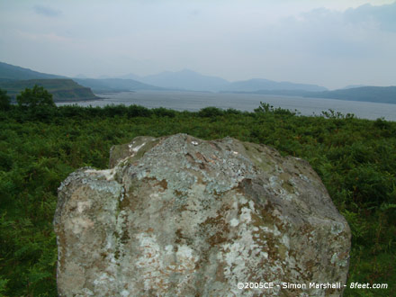
Taken 11th August 2004: Looking approximately north towards Loch Caol.

Taken 11th August 2004: On an appallingly wet day, here’s a photo of Fionnphort taken from the car.
This is what summer on Mull can be like. Based on Nick’s photos, we should have visited during the winter.

Taken 10th August 2004: Looking approximately north east at the northern arc of the circle.
Taken 10th August 2004: Viewed from the south west.

Taken 10th August 2004: Looking north east, with Lochbuie Circle visible to the left of the outlier.

Taken 10th August 2004: Peering through the rain. Here is the stone with the other outlier and stone circle just about visible in the background.
Louise is obligingly wearing a red coat and standing next to the other outlier. The strange white blob in the sky isn’t a UFO... it’s rain.

Taken 10th August 2004: The stone viewed from the south east in miserable wet weather.

Taken 10th August 2004: I call this composition"Tree & Rock”.
Actually there are a couple of ‘rocks’ in the shot. It gives an indication of how the trees are engulfing the cairn.

Taken 10th August 2004: Viewed from the north (that’s very approximate).

Taken 10th August 2004: The stone viewed from the south east.

Taken 10th August 2004: Lochbuie Standing Stone viewed from the north west (I think) with William standing alongside it. Note how water-logged the ground around the stone is.
Will’s strange attire is the result of his bungling parents forgetting his rain gear (he’s wearing my fleece).

Taken 9th August 2004: Loch Sguabain and Caisteal Eoghainn A’ Chinn Bhig viewed from the A849.

Taken 9th Auhust 2004: A close-up of the crannog, taken from the A849.

Taken 9th August 2004: A gratuitous photo of my stone hunting ‘buddy’ William alongside the stone at Gruline, viewed from (something like) the north.

Taken 9th August 2004: Viewed from the west (I think).

Taken 9th August 2004: Gruline from a distance. This photo was easy to take (no bull!).
Taken 8th August 2004: The tip of the stone with Loch Tuath behind it.

Taken 8th August 2004: Polished by livestock, here’s the pronounced edge of the stone.

Taken 8th August 2004: With Loch Tuath behind it, here is Kilninian viewed from the north east (approximately speaking).

Taken 8th August 2004: Looking along the row.

Taken 8th August 2004: Louise and William at Dervaig B (Louise is 5ft 6 inches tall).

Taken 8th August 2004: Not a gratuitous ‘family snap’ but members of my family giving an excellent indication of scale. Here are all three stones viewed from the south west with the cemetery visible in the background.

Taken 8th August 2004: The largest of the remaining stones in the Dervaig C row, here viewed from the south.

Taken 9th July 2005: Looking directly down the gallery from the eastern end.

Taken 9th July 2005: Viewed (approximately) from the north east.

Taken 9th July 2005: Viewed approximately speaking from the south east.

Taken 6th August 2004: Fang Circle from the north. Louise (in red) is standing in the circle. To the left of the frame is the sheep-pen which has some of the stones incorporated into its wall.
This image is a panorama created from two photographs using Autostitch (www.autostitch.net). As such some distortion is likely, and the image may give a slightly misleading impression of the site. This is the case with all panoramas.

Taken 6th August 2004: What I interpreted as the most southerly stone of the circle, now incorporated into a wall.

Taken 6th August 2004: The two ‘wall free’ stones.

This map is intended to make it a bit easier for anyone who wants to visit Bedd yr Afanc. I’d recommend you do this walk in good dry weather, using my map in conjunction with an Ordnance Survey map (or Multimap printout).

Taken 15th August 2004: The foot of the stone (I think this is on the east side).
The top frame shows erosion around the foot of the stone, and the bottom frame shows what way be a packing stone.

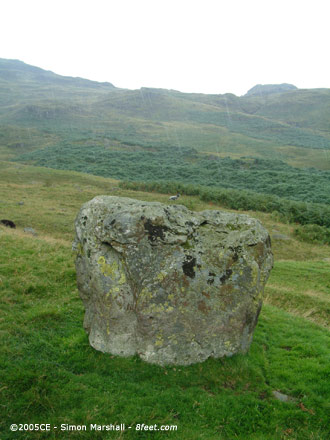
Taken 15th August 2004: The stone viewed from the south west.
Taken 15th August 2004: The stone viewed from the east (or thereabouts) with evidence of precipitation.

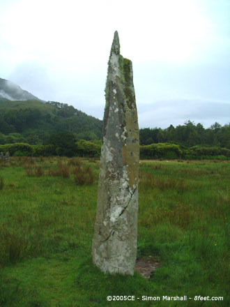
Taken 15th August 2004: Just before the rain set in, here’s the stone looking approximately east, down the pass towards Little Langdale.

Taken 6th August 2004: One of the fallen stones, with what appears to be the remains of a stone socket underneath it.

Taken 6th August 2004: Two of the stones with the A859 visible in the background.