I should have read the previous fieldnotes! I scrabbled around trying to see anything, until I stumbled upon the bridle path. I managed to spot the stone through the hedgerow, and grabbed this shot.
ocifant

Seen from the bridle path to the rear of the houses.
Image credit: ALan S>

This also is not the true Ffynnion Druidion stone, but following Kammer’s lead, I’ll call this ‘Ffynnion Druidion JCB2’. It lies in a field to the NE of the real stone. I saw it whilst parked at SM921371.
Image credit: ALan S>


These stones are by the information board. Not sure if they’re part of the site or not...
Image credit: ALan S>

Mentioned on an information board at the west end of the village, but I couldn’t locate it, and a local postman wasn’t aware of it when I asked.
There is a quarry to the north of the village, and the chamber is shown on the OS map as close to the quarry. Hopefully its still there...
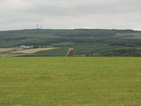
Spotted this from the N25 on our way home. It looks to be around 5 feet tall. Once again, cows in the field prevented a closer look.

The two major stones in the row, showin gthe small boulder placed on top of the middle stone.
Image credit: Alan S>

Marked as ‘standing stones’ on the OSI map, I’d expected to find a pair here. What I actually found was a three stone row. Two of the stones are similar in size, and about 5 metres apart. The third is much smaller and about 25 metres to the NE of the other two, but in line with them. The middle stone had a small boulder placed atop it. I didn’t enter the field due to the presence of cows nearby.
Who put the stones up? We did!
THE first analysis of DNA passed from father to son across the UK has shattered the Anglocentric view of early British history, it emerged yesterday.
For decades, historians have believed that successive waves of invaders, such as the Anglo-Saxons, drove out the indigenous population of the British Isles, labelled Celts, pushing them to the fringes of Ireland, Scotland, and Wales.
However, work by a team of scientists on the Y chromosome, which is passed from father to son, has shown the native tribes left their genetic stamp throughout the UK and not only in the “Celtic fringe”.

Also known as The Bard’s Stone, Cwrt-y-Filiast, The Greyhound Kennel, Llech yr Ast or Cwrt-y-Bugail according to Barber and Williams’ The Ancient Stones of Wales.
Note re location from Stones Mailing List:
Go through the field gate opposite the fancy gateway to Trewardreva.
The fogou is in a low mound by the edge of the field more or less directly in front of you, but slightly to the right. The entrance is in the brambles at the nearest end, but it’s quite accessible.
The instructions below are spot on for finding the stone(s), but I think Grid Ref SP782416 is more accurate than the one given.
Lying within a nature conservation area, the walk alongside the river is well maintained, and it’s possible to see that the stones are resting on the surface rather than being embedded in the ground. That suggests to me that the stones are not that old, but I’d be happy to be proved wrong.
I parked spot on the grid ref given, but couldn’t see the stone anywhere. There’s a footpath leading behind the houses, but nothing to be seen there, and a footpath on the open ground on the other side of the road. I drew a blank.
Any specific directions to find the stone would be useful (unless the grid ref is actually wrong)

This appears to be just resting on the surface, so I suspect it can’t be that old...
Image credit: Alan S>

Two stones, or two parts of a single stone?
Image credit: Alan S>
I’m not normally one for churches (I tend to burst into flames!), but I couldn’t pass this one up.
Therer’s a delightful old wooden ‘turn’-stile into the field containing the church, which is contained in the middle of a field.
As juamei says, there’s a trapdoor to the right inside the church proper, and a sarsen can be seen here. There’s what looks like a drill hole, at least 6 inches deep into the stone, and the end nearest the door looks as if it’s been sheared at some point – very flat and angular. Sadly, the other trapdoor cannot be opened due to staging being constructed over it – I’ll try writing to the church conservation people to find out why.
It was a very peaceful and cool place to rest on a warm day though. And there are information leaflets available about the church (which don’t mention the sarsens at all).


Thanks to a friendly local, we had little difficulty in locating the ‘car park’, and the walk up the hill didn’t seem that far either.
First view is amazing as you come to the stile and realise it’s just there in front of you!
I had remembered my torch, and crawled inside, but found the external light was sufficient to see what I was doing. But, being a wuss in confined spaces, I didn’t go all the way in – just past the first side chambers was far enough for me to explore.
I tried a couple of basic chants to test the acoustics before I left, but found that the sound was just absorbed by the stones (the ‘eggbox’ effect).
Sitting outside and facing the entrance I noticed that the hills behind the barrow seem to surround and ‘cuddle’ the barrow itself. Has anyone else noticed this, or is it just my imagination? I was reticent to leave, but with Mikki waiting down below, I reluctantly returned to the car.


Approaching from the East, Lanhill Farm is on the left. Shortly after this, there is a pull in to a gate for a field, with a footpath sign present. I managed to pull off the road, out of harm’s way here.
Instead of doing the intelligent thing and taking the footpath, I walked along the road until I saw the barrow through the trees, then navigated the knee high nettles and jumped over the fence.
The barrow was an absolute delight, covered in buttercups. No livestock in sight. It certainly pays to circumnavigate such things as I wouldn’t have known about the chamber on the southern side if I hadn’t. Taking some photos, I had the fright of my life when I nearly stepped on a pheasant resting in the long grass. It took off like a rocket as I stepped backwards, framing a shot.
Looking in the chamber, some remedial work has obviously been carried out, as iron girders are holding parts of the roof in place.
A nice barrow, in a pleasant setting, on a glorious day.
I’d failed to find this site on a couple of previous occasions, and had been told it’s tricky to find, but strangely went straight to the stone this time round with no problems whatsoever.
From the A229 southbound, take the slip road immediately after the Shell garage, and park. Walk back toward the garage, and follow the path round to the right. There is a bridge across the railway line, the stone is less than 100 yards up the footpath on the left.


I was so angry after visiting this, the last stop of the day. Some idiots had set a camp fire within about 8 feet of the stones (see picture). The ashes were cold, but didn’t look as if they’d been rained on, so were obviously recent and fresh. In addition, one of the rails of the surrounding fence had been broken, presumably during the camp’s high spirits.
On the positive side, I learned something new. This was originally though to be the remnants of a stone circle, as shown by a plaque at the base of the terrace.
Mentioned in Dyer’s “Discovering Prehistoric England” as “a late Iron Age, univallate hillfort of irregular shape and about 10 hectares in extent” .
We drove right by it, according to the map, but couldn’t see much at all through the trees.

Bastards! What kind of people do something like this, then claim to be in touch with the spirits of place? There are obviously regular meetings here, judging from the detritus spread around, the numerous clouties in the trees and the fire pit (it was cold).
If I were local, I’d set the old bill on ‘em.
Image credit: Alan S>


The original ‘information’ sign. It reads:
Goldstone Tolmen
??? ???
Holy Stone of Druids
Image credit: Alan S>


17 May 2003 The outer Ditch and Embankment in the descending mist.
Image credit: Alan S>

17 May 2003
The stone in all its ‘glory’... Anyone got a skip? I’d like to shoot the people that do this kind of fly-tipping.
Image credit: Alan S>

17 May 2003. The stone in all it’s glory
Image credit: Alan S>
What a place! The road leading up to the track is a normal seaside town suburban road. Bungalows and terraced houses with clipped front lawns and twitching net curtains. All very nice and Stepford.
The track leads up past some allotments, and then the fun starts.
Most of us carry a plastic bag to put rubbish in when we visit sites. I think this place would need a fleet of dumper trucks. In a walk of less than 500 yards, I saw 2 mattresses, an armchair, 3 large gas canisters and countless bags of assorted household refuse. I seriously thought I’d strayed onto the council tip at one point, and if it weren’t for the GPS telling me I was getting close, I’d have given up.
Very very sad. I’d planned to continue on to look at Thunder Barrow, but was so depressed by what I’d seen when I reached the stone, I turned back to the car.