


The barrow only just visible through the scrub. Taken standing in the ditch.
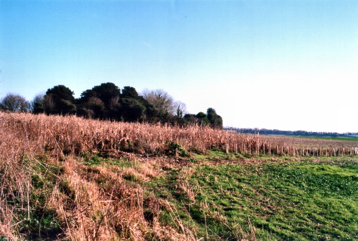
When Hampshire Treasures describe this as “overgrown” they’re not joking! The site of the barrow is easily seen from the road as it is crowned by Yew trees.Closer to, it seems to be surrounded by a very overgrown hedge but after struggling through this it becomes apparent that it is Ivy clad scrub growing on the outside and partly down the very well defined ditches. The barrow itself is the shortest “Long” barrow I’ve seen and has a very dumpy appearance, however its actual outline is difficult to determine as the Yews are falling over, re-layering and/or rotting and there are huge mounds of fresh chalk everywhere caused by active badger setts. The ditches are heavily weed infested and a winter visit left me picking burrs out of my clothes for some time.
What does one do about a site like this? Clear it of the untidy scrub and dead trees and restore it to some of the majesty it had when first constructed or leave it to gently decay and remain the undoubted wild-life sanctuary it surely has become?
Disabled: Parking on small verge just off the road. Walk up-hill on very deeply rutted track (Much used by off-roaders while I was there), locked farm gate, ploughed field, many brambles and much scrub and uneven ground.
A really impressive barrow indeed. While not as long as Knap Barrow next door, it is much higher and quite overwhelms close to. Very well preserved with a remarkably smooth outline like a large whale breaking the surface. Interesting that its orientation is almost at right-angles to its companion. Mostly clear of scrub growth although it is encroaching from the north.
Disabled: As Knap although both would be accessible by a 4x4. Open farm gate.
A unassuming little stone just over a metre high marking the tip of a point where the Wilts boundary takes dog-tooth shaped bite out of Hants. Grim’s Ditch1 mile to the NE points directly to this stone but to the NW seems to want nothing to do with it. Marked with an Ordnance Survey carving and accompanied by a small Victorian concrete boundary (?) post. The stone itself seems to be of the generic “Sarsen” type so was probably moved some distance.
Disabled: Approach by car along a flat, slightly rutted track (care in very wet weather) and park next to stone on grassy triangle without blocking the tracks. Access to Grans Barrow and Knap Barrow is best attempted from here for the more mobile.
This has several similarities to the West Kennet Long Barrow. For a start, a slow climb up the hill with the barrow invisible until the last moment, then its length is comparable, being only a few metres shorter and its orientation as (very!) roughly E/W. No stones unfortunately, only a little Victorian concrete post at the E end. The condition is good with none of the mutilation seen at the WKLB evident. Only one worry is that the track to the S. beloved of off-roaders, is not fenced off and is perilously close. A small amount of scrub clearance at the W end would be an improvement. Wide views to the N and prominent tumuli on the skyline to the S. Grans Barrow is very close by. A fine and well preserved site but very exposed in winter gales as I found out!
Disabled: Longish walk up hill in rutted and grassy track if approaching from the Sarsen stone. Note.. Take the left track of the two going south.
The SW entrance with Salisbury Cathedral in the distance.

Showing the wide berm between the outer bank and the inner ditch.


The SE Entrance.


The Tor in its wider landscape. From the Old Wells Road, about 6 Miles NE.


Looking NW with Hants on Right, Dorset on Left over bank and Wilts by trees in background.
“.......As for this site (PRN 2064), we have recorded it as a folly on the SMR. A primary source is the Country Life article, May 7, 1981. Apparently the chapel was built over the original site of the circle; the circle was first reconstructed in C17. Re-erected in 1981 “as near as possible in its original formation.” There are additional sources within the SMR which you are welcome to consult during opening hours by appointment.”
County Sites and Monuments Record Officer
Central Library, Westgate
Oxford OX1 1DJ
01865 810825
Does this site now class as a modern folly, a very curious C17 re-working of a Neolithic site or a semi-faithful reconstruction of a destroyed monument?
I can only leave it to the Eds to decide whether this should remain on TMA. My own feeling is that it should remain if only to show the curious cheek by jowl jostling of different beliefs.
One wonders whether they would allow a Druid ceremony to be held there...........?
Barrow-like mound surmounted by a yew tree at ST052214. {1}
The mound is circular, although slightly truncated at its N side. E-W diameter is 9m, N-S diameter 7m and c1.25m high. The centre of the mound is about 17m due S of the E wall of the chancel. It is crowned by a massive yew stool with a number of trunks and is clearly very old. {2}
NGR should be ST052213. {3}
Very doubtful. {4}
References:
1 Mention – Proceedings of the Somerset Archaeology and Natural History Society Aston, M 1976 “Somerset Archaeology 1974-5” vol 120, 71
2 Personal communication – Burrow, I SCPD 07.03.84
3 Detailed records – Ordnance Survey Archaeology Division 1976 ST02SE(M) SCPD
4 Mention – Quinell, NV quoted in Grinsell, LV “Somerset Barrows: revisions 1971-87” Proceedings of the Somerset Archaeology and Natural History Society 131 (1987), 22.
Record created by:
Ian Burrow in March 1984
© Copyright Somerset County Council 2003
The authenticity of the mound as a barrow is in question.
With thanks to the Somerset Museums Service for their help.
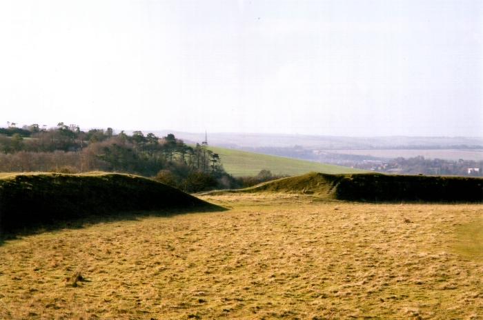
Class 1 henge monument of single causeway type consisting of a circular rock-cut ditch with an external rampart of earth and stones, enclosing a flat central area without any form of upright. The causeway is to the N. The ditch varied in width from 12ft to 21ft and 4-9ft deep. The NE and SW segments yielded evidence of Beaker occupation. This was separated from the ditch bottom by a barren yellow clay silt layer. In two places a platform of closely packed stones was interposed between the clay and beaker deposit, which consisted of dirty rubble, charcoal, hearths etc. Finds from this deposit included 4,000 flint flakes and implements, pottery of A-C beaker type (including rusticated ware) representing at least 100+ beakers, a few sherds of Neolithic “B” ware and large quantities of animal bones, mainly domestic. No evidence was found of stone or post holes, walling or any other structural remains. Two hypotheses can be suggested – the monument may be attributed to the grooved ware or “B” beaker group, or the A.C. beaker folk for whom the ditch held no significance. {1}
The beaker burial and occupation deposits had radio-carbon date centring on 1900-1700bc. {6}
The henge is set on a gentle E-facing slope to the W of Long Wood, in improved pasture. Condition is generally good except for three hawthorn trees growing in the ditch. {7}
The majority of the archives and finds were destroyed in the Second World War. {8}
The monument is in a generally satisfactory condition with no evidence of damage by grazing cattle. {9}
References:
1 Excavation report – PUBSS Jones, S.J 1935 “...Excavations at Gorsey Bigbury...” vol. 4(3), 174-8
2 Excavation report – PUBSS Jones, S.J et al 1938 “The Excavation of Gorsey Bigbury” vol. 5(1), 3-56
3 Excavation report – PUBSS ApSimon A.M 1951 “Gorsey Bigbury: The Second Report” vol. 6(2), 186-200
4 Detailed records – Ordnance Survey Archaeology Division 1966 ST45NE15 SCPD
5 Excavation report – PUBSS Tratman, E.K 1966 “Gorsey Bigbury...Third Report” vol. 11, 25-30
6 Description – PUBSS ApSimon A.M 1976 “Gorsey Bigbury...dating...” vol. 14(2), 155-183
7 Personal communication – Burrow, I SCPD (13.09.82)
8 Archive – UBSSM
9 Detailed records – Field Monument Warden’s report (22.4.1998) in HER files
Record created by:
Ian Burrow in September 1982
© Copyright Somerset County Council 2003
(Edited) With thanks to the Somerset Museums Service for their help.
“The stone circle is of comparatively recent construction, but of stones found in the vicinity which correspond in type to a cornerstone underpinning the medieval chapel here. By implication these stones were part of a much older pre-Christian circle which was located where the Chapel now is. As you know it was frequently the habit in medieval time to “claim” a pagan circle for Christianity by including a stone in the foundations for the new christian chapel.“.....“Stones have been re-located here in the last 30 years or so, I believe”
With many thanks to John Weaver, Administrator of the Stonor Estate for these observations.
The Estate re-opens in the Spring so any investigations as to stone type and source must wait till then.
This Web site suggests that the stones are a reconstruction, curiouser and curiouser!
Curious that this site is not better known as it is at a very public location. Stonor Park is visited by thousands but on the web site no mention is made of this Neolithic(?) monument. The circle is right next door to the Catholic Chapel and does one sense a touch of embarrassment?
I visited this site a huge number of years ago(I used to knock around with one of the younger sons of the family) so the memory is a bit dim but I remember an earthwork and several standing stones. There is a small image available on the Google search but it’s not much help.
I tried trawling through Oxfordshire CC’s Web but couldn’t find much, perhaps someone knows the right site to go to for more information.
Some pics would surely bring this circle back to the prominence it deserves.
A search on Google suggests this may be Romano/British in date.
As Grrr notes this is all occupied by a very smart stud farm but a footpath skirts the N side and views of the ramparts can be seen from here. Following the side road signposted to the church, much better views can be had of the S side.
Disabled: Parking might be possible at the stud farm (Please ask) and part of the N part is circled by a flat path with wide views to the N. To the S, parking is possible where the road branches to the church (is this area private?) but the road is steep.
What a busy little bit of Hampshire this is! The Counties of Dorset and Wiltshire meet, the Dorset Cursus approaches from the SW,the Ditch(Dyke?) forms the boundary in association with Grim’s Ditch, a Long Barrow, tumuli and enclosures and a finely prominent aggar of the Roman Road.
A short walk SE shows that the earthwork is still very well defined and preserved, on the NE(Hants) side a deep ditch, on the SW(Dorset) side a smallish bank, Which was the defended side? Grim’s Ditch marks the boundary of a vast Bronze Age ranch so it would be nice to know which earthwork came first.
Disabled: Difficult from where I parked in the lay-by on the A354. However, my old map didn’t show the new parking area shown on Streetmap. Where I walked was flat but bumpy.
Couldn’t see this at first as the approach to the top of this bare and almost flat topped ridge hides it from view. Once there however it’s quite rewarding, a sinuous ditch with banks in places, sometimes climbing gently up the hill or following the contours where the ditch becomes a flat path with the natural steepness of the hill on one side and a smaller bank accentuating the drop on the other. From looking at this very short section it’s impossible to say whether it was built to keep raiders out, stock in or a huge statement of property ownership. Was it pallisaded? It seems unlikely as maintenance and patrol of this vast ranch boundary would tax even a modern stock farmer.
(“Soldiers Ring” ESE, marked by a prominent clump of trees, is Roman)
Disabled: Parking available up a cobbled road, right next to a gate. Gentle slope on grazed turf to top from where some of the ditch can be seen. Extensive views.
An excellent resourse for finding details of sites in Somerset.
Bronze Age barrow cemetery of seven barrows in Priddy parish (PRNs 23952 23953 23954 23955 23956 23957 23958) and two further ones in Chewton Mendip parish (PRNs 23243 23244 ). Comprise Tratman’s T328-T336 and Grinsell’s Priddy 28-34 and Chewton Mendip 13-14. See individual PRNs for individual descriptions. There is another possible barrow to the SW (PRN 24008). {1}
Wick’s concluded that this chain of barrows had been wrongly named and the name should apply to the group to the N on Ashen Hill (PRNs 23813 23814 23815 23816 23817 23818 23819 23820). {2}
This was challenged by Grinsell who examined the available documentary evidence and revealed that this S group had been consistently known as Nine Barrows since 1296 and was often mentioned in several medieval and later surveys because the Chewton Mendip-Priddy parish boundary passes through them. {3}
Group of seven barrows in approx NW-SE alignment with two detached. All under pasture and standing 1.2-1.5m high. Prominent position and in good condition. Scheduling revised 1992. {6}
References:
1 Personal communication – Dennison, E SCPD 29.08.85
2 Mention – Proceedings of the Somerset Archaeological. Nat. History. Soc. Wicks, A.T 1952 “Priddy Barrows: an error...” vol 97, 185-6
3 Mention – Proceedings of the Somerset Archaeological. Nat. History. Soc. Grinsell, L.V 1982 “Priddy Nine Barrows...correction... vol 126, 103-4
4 Detailed records – Ordnance Survey Archaeology Division 1982 ST55SW75 SCPD
5 Detailed records – HBMC Field Monument Wardens report SCPD
6 Correspondence – HBMC to SCC 22 Jan 1992
Record created by:
Ed Dennison in August 1985
© Copyright Somerset County Council 2003
With thanks to the Somerset Museums Service for the link to this information.
A small rock shelter near the head of Ebbor Gorge known as “Bridged Pot Hole” consists of a funnel-shaped dissolution hole some 8-10ft in diameter, partially roofed and open on the downhill W side. It was discovered and partially excavated by Balch in 1926 who found in the first 2ft a few fragments of hand-made black pottery, and a decorated fragment possibly of a beaker. At 3ft a polished stone axe 7” long was found – probably of Neolithic or Early Bronze age date, also a flint knife 4.25” by 1.25”, a short scraper and a number of flakes. In a niche in the rock a hoard of eleven leaf-shaped bifacial spearheads, and a group of levelling flakes were found. Late pleistocene bones occurred from 4ft to 8ft. This site provides evidence of human occupation of apparently Upper Palaeolithic character associated with a late glacial found. Finds in Wells museum. {1}
References:
1 Detailed records – Ordnance Survey Archaeology Division 1966 ST54NW30 SCPD
2 Mention – Proceedings of the Prehistoric Society 1959 vol 25, 262-4
3 Excavation report – Antiquaries Journal 1928 vol 8, 197-204
4 Finds stored – WELLSM
Record created by:
Ed Dennison in September 1985
© Copyright Somerset County Council 2003
With thanks to the Somerset Museums Service for the link to this information.
On the W side of Ebbor Gorge is a little creep leading to a shelter known as Outlook Cave. A leaf-shaped flint arrow or spear head was found at a depth of 1ft in the entrance way and is now in Wells museum. Human bones lay just on the surface of the inner cave floor – obviously dug up by animals – but with no associated finds. Further digging revealed remains of the bear and reindeer, a fragment of fingernail decorated light brown ware (the edge of a cup or bowl) and two fragments of undecorated black ware. In conclusion this would seem to be an occupied rock shelter of Neolithic and possibly earlier date. {1}
Scheduled 27.9.91. {5}
Some confusion over location as scheduling document gives different NGR from OSAD. English Heritage NGR given above, as OSAD reference is called Lion Cave on OS map. {6}
High on the right bank of the gorge, 58m above the present valley floor and 50m below the plateau. An artificially widened entrance 1m by 1.5m high leads to a small chamber extending c.12m, with a passage to the east. {8}
References:
1 Detailed records – Ordnance Survey Archaeology Division 1966 ST54NW29 SCPD
2 Mention – Balch, E 1914 “Wookey Hole: its caves and cave dwellers”, 146-7
3 Mention – Balch, E. 1947 “The Great Cave of Wookey Hole”, 96-7
4 Finds stored – WELLSM
5 Correspondence – EH to SCC 30.9.91 scheduling doc.
6 Personal communication – Webster, CJ SCED
7 Description – Barrington, N, and Stanton, W 1977 “Mendip – The Complete Caves..”
8 Detailed records – MPP evaluation 1986 in HER files file
9 Sketch plan – Caves of Ebbor Gorge sepS6 see ref {8}
Record created by:
Ed Dennison in September 1985
© Copyright Somerset County Council 2003
With thanks to the Somerset Museums Service for the link to this information.
Southernmost of the four Priddy circles. Excavations in 1956-9 in the NW quadrant revealed that the bank had a stone core with a ring of post-holes on each side. The posts had been of 8” diameter and about 10ft high with stakes between them, apparently erected prior to the ditch, whose upcast was added to the bank probably leaving the posts projecting at least 4-6ft above the earth top. A causewayed entrance was proved for the circle in the NNE sector. Central area was devoid of any structure and no finds were made. {1}
Belongs to the secondary Neolithic and fall into the Henge group of monuments, class 2. Banks average 1m high and the ditch is 0.4m deep. {4}
Bank at best 7m wide and nearly 2m high, interior area flat and about 1m above the surrounding fields. Divided ownership marked by stone wall running NNW-SSE. Part on the W has never been ploughed but is somewhat cut about by old mine workings. On the S the bank is not well preserved. On the E the interior of the circle has been ploughed at some time but the bank is untouched. Some evidence of the stone construction of the bank is visible at some points. Few thorn and gorse bushes on the E side. {5}
Ploughing of centre and surrounding area but not bank in 1984-5. {6}
The interior of the E part of the circle has been ploughed again this spring. One quite large stone has been disinterred and added to the bank. {7}
Many of the surface depressions in and around the Priddy Circles are natural sinkholes, not mine workings as had been assumed. Unsatisfactory ground conditions (the ground remained liable to subsidence) may have been one of the factors that led to the abandonment of the whole ceremonial site before the circles were completed. {10}
Scheduling revised with new national number on 31.1.1997 (was Somerset 119). {11}
See PRN 90072 for inconclusive geophysical survey and discussion. {12}
The monument is basically stable under pasture but there are areas of scrub, nettle, bracken etc growth on the banks. {13}
See PRNs 24043, 24045, 24046 for the other three Priddy circles. {14}
References:
1 Excavation report – PUBSS Taylor, C and Tratman, E.K 1956 “The Priddy Circles...” vol 8(1), 7-17
2 Mention – PUBSS 1960 vol 9(2), 64
3 Excavation report – PUBSS Tratman, E.K 1966 “The Priddy...Henge Monument” vol 11(2), 97-125
4 Detailed records – Ordnance Survey Archaeology Division 1966 ST55SW4 SCPD
5 Detailed records – HBMC Field Monument Wardens report SCPD
6 Personal communication – Dennison, E SCPD 12.09.85
7 Detailed records – HBMC Field Monument Wardens report SCPD
8 Aerial photographs – Slide SCPD 2.040.0004
9 Map – HBMC Field Monument Wardens report SCPD
10 Detailed records – Stanton, WI “Natural sinkholes...Priddy Circles...” PUBSS 17(3) (1986), 355-8
11 Correspondence – EH to SCC (7.2.1997) in HER files
12 Personal communication – Webster, CJ SMRO (14/12/1998)
13 Site visit report – Graham, A. EH field Monument Warden (25/7/2000) report in HER files
14 Personal communication – Matthew Nicholas, SCC (7/7/2003)
Record created by:
Ed Dennison in September 1985
© Copyright Somerset County Council 2003
With thanks to the Somerset Museums Service for the link to this information.
A standing stone, “perhaps of no great antiquity”, about 4ft high. {1}
An upright block of conglomerate 1.3m high and 0.5m by 0.6m in section. Possibly a comparatively modern rubbing stone. The field has been drained by a series of late or post medieval broad furrows dividing the area into plots The stone stands in one of the plots and it seems unlikely that such an obstruction would have survived any arable farming. {2}
Folklore suggests that this is one of two stones thrown by the Devil from Shute Shelve in a contest. {3}
References:
1 Mention – Knight, F.A 1915 “Heart of Mendip”, 332-3
2 Detailed records – Ordnance Survey Archaeology Division 1966 ST45SW1 SCPD
3 Mention – Grinsell, L.V 1976 “Folklore of Prehistoric sites in Britain”, 99
Record created by:
David Fraser in February 1983
© Copyright Somerset County Council 2003
With thanks to the Somerset Museums Service for providing the link to this site.
Two large standing stones, known as the Deer Leap Stones, were formerly situated in an old hedge bank, but this was grubbed out in 1967, the old stones being left standing. A further similar stone was built into the corner of a wall 200m north at the summit of a hill (ST 51714893). Presumably it was emplaced before the wall, perhaps as a boundary stone. At ST 51804910, 300m north of the Deer Leap stones is the stump of a roadside outcrop of quartzite blasted away in road widening, which has been confused with the Deer Leap stones. {1}
A legend of a phenomenal leap by a deer, commemorated by these stones, is well known to old Mendippers. The stones are 16m apart. Until 1964 each stood c.2m east of a dry-stone wall, but in that year the wall was dismantled and workmen broke up the southern stone and damaged the other. The lost stone was subsequently replaced by a similar from a nearby quarry, and the northern raised upright. Stones consist of quartzite, probably local. {3}
According to other local sources the stone was broken up by Italian prisoners of war and subsequently replaced with another block. {4}
References:
1 Detailed records – Ordnance Survey Archaeology Division 1970 ST54NW37 SCPD
2 Mention – PUBSS Tratman, E.K 1968 vol 11(3), 243-4
3 Detailed records – Stanton, W.I. Proc University of Bristol Spelaeological Society 16:1 (1981), 63-4
4 Mention – Brown, D Somerset v. Hitler (1999), 206
Record created by:
Ed Dennison in October 1985
© Copyright Somerset County Council 2003
With thanks to the Somerset Museums Service for providing the link to this information.
The previous antiquity of these stones in their former location/s still seems undecided.
An Iron Age Fort, roughly oval in plan but associated with several Bronze Age earthworks.
An example of a Bronze Age boundary ditch still marking the border between two counties, Hants and Wilts. More obvious to the SW where Bokerley Dyke and the Grim’s Ditch serve the same purpose. What is more startling about this area is the disparity between the concentration of ancient sites either side of the dividing line. To the W. a huge number of tumuli and earthworks, to the E. none at all! The landscape is of similar form and there is no large physical barrier such as a river to provide a logical boundary. A line drawn between two tribes of dissimilar wealth?
This is but a very short section of the remains of a massive earthwork which encloses much of this part of Hampshire. The County boundary still follows the course of this dyke (although not here) which gives western Hampshire a huge penninsular of land which juts into Wiltshire and Dorset. Part of the W boundary is defined by the Bokerley Dyke and a short stretch by a Roman road. Much of the Dyke consists of twin banks with a ditch between. The area enclosed is about 16 sq.miles in extent and deliniates a large ranch belonging to the Middle/Late Bronze Age.
Pevsner/Lloyd (Hampshire & the Isle of Wight) mention that in the 1960s, an excavation near the N defences found the plan of a circular wooden house 25ft in diameter. Pottery dated it to Iron Age B cultures. The site was occupied in the Mesolithic and Roman periods.
Whilst constructing a reservoir at Testwood just outside Southampton, Southern Water uncovered the remains of a Bronze Age bridge.
Two large ramparts and outer ditches with a counterscarp on the northern half. The fort covers about 16 acres and is Iron Age in date.