


This large round barrow is sited on the western flank of Sidbury Hill.
It used to stand at the crossroads of two trackways used by tanks, you can imagine how it came to be called the Hot Cross Bun.
The army is more sympathetic to the ancient remains lying on its land nowadays, hence it is now out-of-bounds to all army vehicles.

Here lies the Weather Hill henge, but I could only make out the tank tracks which cross it.

The henge is protected by these wooden posts, but I couldn`t see any evidence of it on the ground.
I visited this site in the summer of 2002, accompanied by a Wilts archaeologist who called it `the Everleigh henge`, however, jimit has pointed out that on the SMR it is named Weather Hill henge.
Although being on MOD land, the henge can be visited when no army exercises are taking place nearby.
There`s not much to see here. I couldn’t make out any evidence of the bank and ditch; still, the site is clearly marked by the wooden posts and noticeboards surrounding it which warn off the army vehicles from straying over the henge.
Lying on Salisbury Plain, within 8 miles of Stonehenge, this henge was not re-discovered until 1996 when it was spotted from an aerial survey. A subsequent geophysical survey confirmed its presence.


From Moel ty Uchaf, I looked down upon Tyfos, two miles away. Through the haze I was surprised to see a round field next to the cairn circle. (Tyfos is the blob in the small field to the right of the circular field, next to the Tyfos Farm buildings.)
I visited this mound yesterday on my way back from Avebury after the solstice celebrations.
As it was a Sunday, I drove straight through the main college gateway, parked in the central area and asked a student for directions. I was told to go down a small flight of steps which led behind the canteen....and there it loomed before me.
Hemmed in behind the backs of buildings, overgrown with trees, yet quiet and peaceful because of it.
You have to climb this mound to fully appreciate it and there are steps on the opposite side.


Nine Stones Close stone circle acts as a handy scratching station for a passing cow and calf. Robin Hood`s Stride can be seen in the right background, with Cratcliffe Rocks hillfort/settlement to the left.


showbizireland.com/news/may03/01-flatley26.shtml
Lord of the Dance Michael Flatley landed smack-bang in the middle of an important cultural heritage site on the grounds of his new home Castlehyde in Cork on Monday.
Michael Flatley seems to be never far away from controversy and the 6 euro million refurbishment of his mansion in Cork hasn’t been without delays and setbacks.
So when his workmen uncovered a 4,000 year old burial chamber while digging a septic tank on the grounds it might have been less complicated for the billionaire to simply cover it up and say nothing.
But not Michael! The talented dancer and businessman is delighted with the find which uncovered two perfect earthenware jars last Monday.
He told the Evening Herald: “It’s just incredible. It’s possible there is a whole Bronze Age graveyard in this area. There certainly should be a major study done on this site, and what else could be lying undiscovered?”


Castlehowe Scar Stone Row?....looking north. The stone circle is just beyond the wall at the top of this photo.

On a recent visit to the Castlehowe Scar Stone Circle, I looked in the next field and was astonished to see what appears to be a stone row! I presume that if this is `really` a stone alignment then we would have known about it by now. If anyone has any thoughts or information about this then please share it with us.

To reach this Hoar Stone, I parked on the A4260 next to a private road leading to Barton Lodge, then walked along the public footpath which follows the private road. Where the footpath turns north, I struck off in a WNWesterly direction through a plantation of young trees. After about 100yds I came across a small mound, only one yard high and about twelve yards in diameter. In a hollow in the middle of the mound lay the 11ft long Hoar Stone.
This site is no longer marked on the OS Landranger map. I reached it by scrambling over the barbed wired hedge running beside the A4260.
When I found it, I was a little confused....it looks like a cairn at the end of a ploughed-out long barrow. Most of the stones don`t look as if they`ve been lying there for thousands of years.
Back home, I did a little research. It seems that in 1843ad a tenant farmer broke up the Hoar Stone. When the landowner found out, he stopped him from doing any further damage.


This barrow was excavated between 1965 and 1970. The bones from between 46 and 49 individuals were found. One skull is said to have an embedded projectile injury. The remains are now stored in the Natural History Museum.
I read somewhere that the stone chamber was removed and now forms a display within Woodstock museum.
I`ve checked with the museum and the stone chamber is no longer on display, but is lying on pallets in their stores.
An excavation begun 12 years ago by a lone amateur which has turned into one of the biggest and most important archaeological sites in the country has been awarded the first part of a grant that could be worth over £160,000 from a fund providing benefits to the community from the quarry industry.
The Bestwall Archaeological Project has uncovered more than 7,000 years of history at a 55 hectare quarry to the east of Wareham, Dorset. The quarry includes one of the largest areas of Middle Bronze Age landscape ever to be excavated and the most substantial ranges of Bronze Age pottery yet discovered in Britain. Also among the finds are Bronze Age ceremonial jewellery and an enormous Roman coin hoard.
Now English Heritage, who helps administer the Aggregates Levy Sustainability Fund, has allocated money to enable publication of the amazing results of the excavations which are due to finish later this year and which are set to add substantially to our knowledge about our distant past. Amateur volunteers from all over Dorset have carried out most of the excavation, led by Wareham historian Lilian Ladle who was asked to undertake archaeological excavations at the site prior to commercial gravel extraction. The project is seen as a shining example of how amateurs and professionals can work together to produce work of the highest standard.
Buzz Busby, Assistant Ancient Monument Inspector with English Heritage’s South West Region, who is overseeing the latest part of the project on behalf of the ALSF, said: “We are delighted to support this nationally important excavation through the ALSF. The project is extremely unusual as projects of this size are generally only carried out by professional archaeological units. Thanks to the support of the quarry owners and professional archaeologists, this truly outstanding research has been undertaken by local amateurs.”
Among the nationally important finds are rare domestic assemblages of beaker pottery from the Early Bronze Age, a feasting site with ritually placed copper alloy bracelets and ceremonial pottery drinking sets from the Middle Bronze Age and extensive evidence of pottery production from the Late Bronze Age. Altogether more than a twelve thousand pieces of Bronze Age pottery have been discovered,
A vivid picture of the Bronze Age Dorset, previously only visible as burial mounds, has now emerged. On the shores of Poole Harbour generations of prehistoric farmers living in large, well-constructed round houses grew wheat, tended flocks of sheep and enjoyed a good lifestyle. There was plenty to eat and, on occasions, great feasts took place. They made their own pottery, developed trade networks, spun wool and wove it into cloth and adorned themselves with attractive, high-class jewellery.
“English Heritage is now planning to investigate the area of the previously collapsed shaft. As part of this assessment we intend to test the consistency of the backfilling in the lower part of the shaft by drilling a borehole through it from the top. Another borehole will be drilled nearby as a control. The information gathered will help us design long-term remedial work.
The work is due to start during the first week of March 2003 and to be completed on site on 26 March 2003.”

Stonehenge painting by John Constable. Oil on canvas. 1836AD

The Hellstone dolmen, taken in Oct 2002, showing the pond which appeared a year earlier.
There is a legend concerning a cow associated with the nearby Mitchells Fold stone circle, Rhiannon`s account of which can be read here:Mitchells Fold

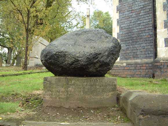
The Cow Stone or Dead Cow from the SW with Stapeley Hill in the background


The 2.5m long, recumbent Cow Stone (or Dead Cow) lies approx 400metres to the NE of Mitchells Fold stone circle, beside the footpath leading from the circle to Stapeley Hill.
In the right light, the stone looks like a resting (or dead) animal when viewed from the west.
GPS: SO 30912 98880


English Heritage`s latest plans for the liberation of the Stonehenge landscape.......and they want to hear what you think!
A laser scan of one of the timbers
A wonderful laser scan of one of the walls


A view across Hampton Down stone circle with Chesil Beach in the background


