
IronMan
Muddy is really just an understatement. It was also freezing cold. Mrs IronMan decided to stay snug in the car with the heating on while I tramped out across the fields to find the site. A few minutes of picking my way through the least muddy parts of the track were swiftly cast aside as I shouted out an almighty “F*CK THIS” and waded through the thick ankle-deep sludge.
The Hellstone is in quite a location, and from here it was easy to pick out the barrows in the surrounding landscape. There seems to be some concern over the accuracy of the reconstruction of this site, but my main problem was with the muddy duck pond in front of the tomb!
I hung around for a while, till the sun began to set, then made my way back through the sludge.
Brean Down was essentially an island up until the medieval period when the surrounding land was drained for agricultural purposes. The thought of having to paddle through foggy swamp to this remote, stormy place is quite something!
In 1896 Marconi made the word’s first radio transmission from Brean Down to Lavernock Point, Penarth.
I was last here a few years ago, on a bit of a random day out, we just stumbled across the place. A few weeks later I read about Brean Down in Ronald Hutton’s excellent ‘Pagan Religions of the Ancient British Isles’. In the book the focus is mainly on the Romano-British temple that once stood here, but very close by is a Bronze Age barrow, and there may well have been more. The temple fell into ruin and was built over with a christian shrine. This too has now completely gone. So in terms of sacred sites, there isn’t a lot to see. However in terms of the sacred landscape this place is completely awe inspiring – I can’t think of many places I have visited which are quite so elemental. You really do feel on top of the world gazing over the edge. The vastness of the sea stretches out before you, and behind the flat marshy plains of the Somerset levels with Brent Knoll clearly visible in the distance, itself the home to an Iron Age fort.
As we left Brean Down the wind howled and a storm was starting to blow in from way out at sea. This is a truly heathen place.

Barrows seen from the ridgeway near the Seorfon Barrows and The Sanctuary – Silbury’s top is in the centre peering above Waden Hill.
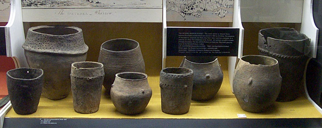


The decorated slab on display in Bristol museum and art gallery, complete with red paint. Faint traces of a seventh foot have been spared the paint for conservation reasons!

Whilst showing a friend around a few sites on Rombald’s Moor we came across this interesting stone, which I haven’t noticed before. So far I haven’t been able to find out anything about it.
A couple of months ago, while doing a bit of reading on my local area, I came across a reference to Ashleigh Street, Darwen, and the barrow that had once been here. I thought about walking down to Ashleigh Street, it being a 15 minute walk away from my house, but ended up sidetracked and thinking there would be no point anyway, as I was under the impression that this was now the site of a building. Today (23/1/3) I decided to pay a visit with my camera, on my way to the supermarket, if only to capture the location of this site. On arriving I was pretty surprised to find that the place had a facelift in 1990 (the book I had read was from the mid eighties) and was now partly restored/reconstructed by the Ashleigh Conservation group. Since 1990 the site must have been left a little, as it did look a little bit shabby (could be the time of year though) and slightly vandalised, but it was a pleasant surprise nonetheless.


A very brief description and a photo of the site are mixed in with a general history of the Ramsbottom area on this webpage.

The clouds in the distance are over the South Pennines and the Peak District.

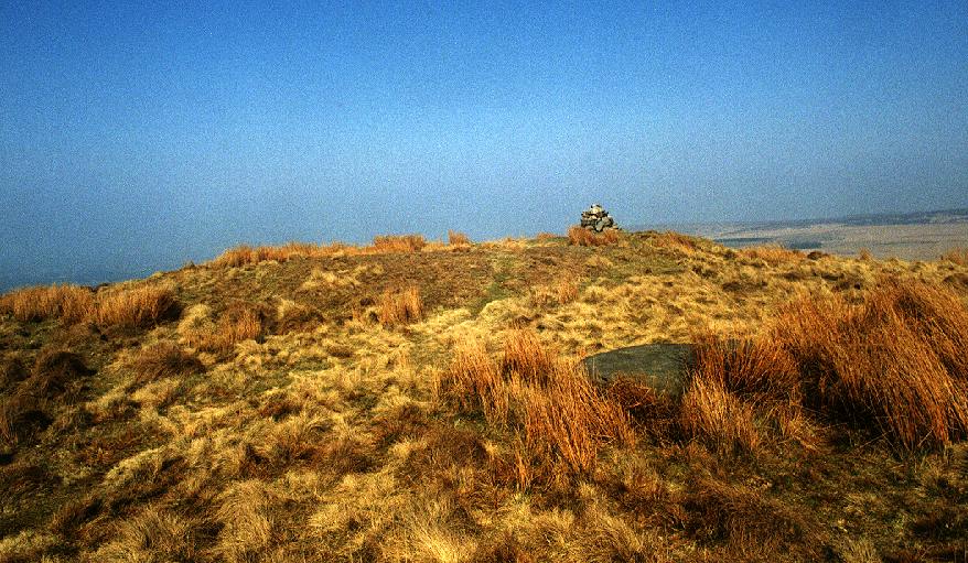
Broken stumps of the stone circle can just be discerned among the tall grass and snow.


A picture of this site.
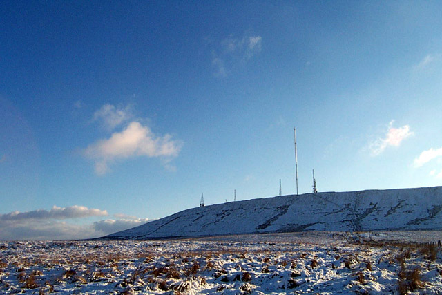
Everything you ever wanted to know about those darned TV masts... oh, and it mentions the cairns and the Rivington Pike beacon fires.

My own interpretive map showing Winter Hill and Rivington Pike as a focal point for this sacred landscape. Each site has a clear view of Winter Hill which dominates the landscape for miles around.
Monuments with a focus on this great hill include Cheetham Close, Round Loaf, Pikestones, White Brow, Sugarloaf Hill, Barrow Bridge and Standing Stones Hill.
The boiler had broken at work and we were sent home, so I thought I’d take the opportunity to satisfy my growing curiosity about this place. Last time I was up here it was raining and the visibility was very poor, so it being a clear and crisp winters day I just had to come. It seems to me that Winter Hill and Rivington Pike are the focal point for most of the monuments in this area. Cheetham Close and Round Loaf have an uninterupted view, as would Pikestones if it wasn’t for the forestry commission trees. Other cairns and stones dotted all around are either in plain site of the hill or actually on it.
This visit was excellent, a friend from work came with me, and we strolled around the top of the hill, looking at all the TV masts. As much as they definitely ruin the hill, a part of me can’t help digging the Star Wars feel they bring to the place, especially in the snow. I even got to thinking about the unbroken lineage of this place – from neolithic sacred hill (if my thoughts are correct) through to beacon hill and on to TV broadcasting... a definite thread there I feel!
While walking around the top we couldn’t help noticing a hang-glider hovering around between the masts. One time as we walked past the guy, we were close enough to see his face, he shouted down to us:
“What time is it?”
“Half past three”, I replied.
“Cheers!“, he responded.
We had a good laugh at the ridiculousness of the situation. Only round Bolton, we concluded.

The ruined cairn near the summit of Winter Hill looking over to Round Loaf (roughly in the center of the shot) and Pikestones (left of shot).


This site, once again, seems to focus on Winter Hill – or more specifically Rivington Pike in this case. The trees now block this view but it seems uncanny that so many sites in this area of Lancashire have a clear view of Winter Hill. From what I can make out on site, and from other images I’ve seen, the entrance to the chamber would have been in the foreground aligning with Rivington Pike.

IronMan is caught, by the chamber, taking a photo... from here a clear circle can be discerned – this would have made up the central section of the cairn, and housed the chamber (see purple diagram!)
Image credit: M. Thornton

Looking out over the chamber to the Lancashire plains and Chorley.
Image credit: M. Thornton
Visited with MushroomSi and Ursula on a tour of a few of the Cumbrian sites at Winter Solstice. This hadn’t been a planned visit, we were driving past when I pointed it out to Si, who as it turned out hadn’t visited before. The car was quickly turned round and we paid a visit. It was worth it just to hear how delighted Si was to be here! I’ve been here quite a few times now but am always amazed as the inner bank comes in to view. Once again I found my mind racing with interpretations of this site in it’s original use.
31/12/02ce A return visit – again I was initially disappointed, I’d once again got it in my head that this stone was bigger! Why I was so bothered I just don’t know. One of my shots shows it to scale, and looking at it now it doesn’t seem that small... The view did again, however, impress me. From here the ugly chimneys of the Shap granite works, belching great plumes of smoke, serve as a reminder of just how close you are to a lot of the other Cumbrian sites, all within pretty easy walking distance.
05/01/03ce A return visit on a beautiful crisp clear winter day with about an hour of sunlight left. The snow on the tops served as a great visual aid, somebody had been here earlier and trodden out the rough line of the circle. Being able to visualise the size and position of the site makes the sad state of the circle all the more poignant. Seeing the size and location of the circle, along with an approximation of the height of the stones, when they where still in situ, brought The Twelve Apostles of Ilkley Moor to mind...

Hellvellyn and the mountains of the Lake District, with Ullswater just in view. Taken from near the Cockpit 31/12/02ce.


Cheetham Close seen from the path below – the dot sticking out on the middle horizon is the trig point at the summit of the hill. The Mire Stone stands, in it’s bog, just in front of this.
On the way up to Kilmartin I vowed not to get distracted and stop off, just get to the B&B and wait till Sunday to explore the sites... this place stopped me in my tracks! It still had me spellbound the next day – the central stone’s carvings in clear definition. I sat waiting for the sun to move and bring new detail to the stone, a totally captivating experience.

Ground plans drawn from two separate archaeological surveys: Dr J. D. Bullock (TLCAS Vol.LXVIII 1958) and Frances Lynch (PPS Vol.XXXII 1966).