
Charters Moss – an ancient bronze age settlement now home to a modern plantation and ‘White Van Man’.
Charters Moss – an ancient bronze age settlement now home to a modern plantation and ‘White Van Man’.

The view from the edge of the field looks across Morecambe bay – it is possible to discern the rough location of The Druid’s Circle of Ulverston. The Three Brothers are in the woodland to the left of Leighton Hall.

There are five stones of this size (roughly 6 1/2 foot tall) in the field surrounding the ‘cairn’ in a roughly semicircular arrangement.


Holy pointed out this particular feature – is it a puppy or a serpent’s head?

Signs of fire lighting – the stone on the right side of the chamber is cracked and very brittle, presumably from campers lighting fires against it. Scorch marks can be seen in the shot, and are more pronounced within the chamber.

Maen-y-Bardd is just visible in the distance, above the capstone.


Barrows seen from the ridgeway near the Seorfon Barrows and The Sanctuary – Silbury’s top is in the centre peering above Waden Hill.


The decorated slab on display in Bristol museum and art gallery, complete with red paint. Faint traces of a seventh foot have been spared the paint for conservation reasons!

Whilst showing a friend around a few sites on Rombald’s Moor we came across this interesting stone, which I haven’t noticed before. So far I haven’t been able to find out anything about it.


The clouds in the distance are over the South Pennines and the Peak District.

Broken stumps of the stone circle can just be discerned among the tall grass and snow.


My own interpretive map showing Winter Hill and Rivington Pike as a focal point for this sacred landscape. Each site has a clear view of Winter Hill which dominates the landscape for miles around.
Monuments with a focus on this great hill include Cheetham Close, Round Loaf, Pikestones, White Brow, Sugarloaf Hill, Barrow Bridge and Standing Stones Hill.

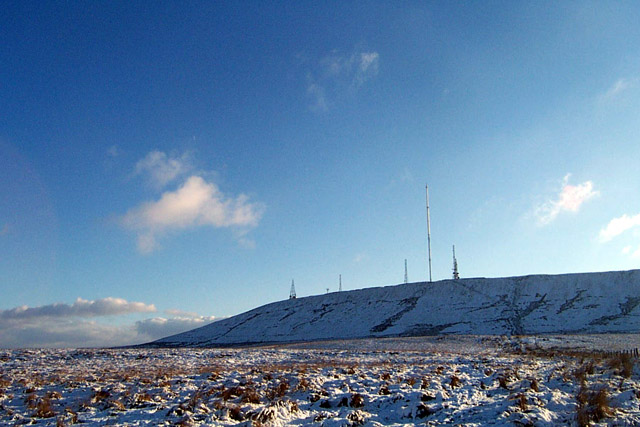
The ruined cairn near the summit of Winter Hill looking over to Round Loaf (roughly in the center of the shot) and Pikestones (left of shot).


This site, once again, seems to focus on Winter Hill – or more specifically Rivington Pike in this case. The trees now block this view but it seems uncanny that so many sites in this area of Lancashire have a clear view of Winter Hill. From what I can make out on site, and from other images I’ve seen, the entrance to the chamber would have been in the foreground aligning with Rivington Pike.

IronMan is caught, by the chamber, taking a photo... from here a clear circle can be discerned – this would have made up the central section of the cairn, and housed the chamber (see purple diagram!)

Looking out over the chamber to the Lancashire plains and Chorley.

Hellvellyn and the mountains of the Lake District, with Ullswater just in view. Taken from near the Cockpit 31/12/02ce.


