phil

phil

All posts expand_more 401-450 of 509 posts

Knowlton Henges

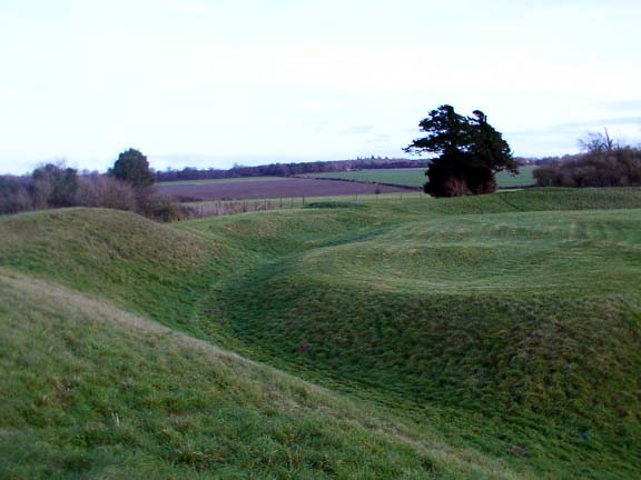
Loved this site! Very easy to reach from the roadside although no direction signs .Very peaceful place only saw 2 other people. The church and henge are very accessable grass is kept very short. Earlier in the day we visited Badbury Rings hoping to find peace but found a heaving carpark and hoards of people walking off their Christmas dinners!

It seems the early Christians made a habit of taking over the old religious sites such as Knowlton Henge. This could be blamed on Pope Gregory who in 601 C.E. said..

“The temples of the idols in the said country ought not to be broken; but the idols alone which be in them . . . If the said temples be well built, it is needful that they be altered from the worshipping of devils into the service of the true God.”

The is a good article on this subject at..
watchtower.org/library/w/1999/3/15/article_01.htm

As you can guess from the URL, the site is Official Web Site of Jehovah’s Witnesses! but it makes interesting reading whatever you chose to believe.

Kernow Phil

Miscellaneous

Warbstow Bury
Hillfort

Sited on a hill, 807 feet above the sea level, Warbstow Barrows is one of the largest and best preserved earthworks in the County.

It has two ramparts, each with two entrances, the inner area being 370 by 450 feet. The outer rampart averages 15 feet in height, with an external ditch 15 feet wide.

In the middle is a barrow, called the ‘Giants’ grave, and sometimes ‘King Arthur’s grave’.

Folklore

Bossiney Mound
Artificial Mound

It is thought that King Arthur’s Round Table is buried at Bossiney Mound.

Once a year, at midnight on Midsummer Eve, it is believed that the table rises out of the ground and stands in the moonlight.

Link

Kelly Rounds
Hillfort
Britannia.com

Discussion of Castle Killibury’s Arthurian Connection
By David Nash Ford.

The concept of King Arthur’s Capital is epitomised by the medieval Camelot, yet some of the earliest references to his court refer instead to the City of Celliwig, a name now associated with Killibury in Egloshayle, Cornwall.

Folklore

Kelly Rounds
Hillfort

And from thence they both went to Gelli Wic, in Cornwall, and took the leash made of Dillus Varvawc’s beard with
them, and they gave it into Arthur’s hand.

-Kilhwch and Olwen in Guest.

Miscellaneous

Merlin’s Rock and the Mousehole
Natural Rock Feature

Mousehole, Cornwall

At the southern end of Mousehole (pronounced “Mouzel”) quay, rising from the water, is Merlin’s Rock.

Here Merlin is said to have prophesied:

There shall land on the Rock of Merlin
Those who shall burn Paul, Penzance and Newlyn.

In 1595 four Spanish galleys fulfilled this “prophesy.”

Miscellaneous

Kelly Rounds
Hillfort

Killibury Castle could be the legendary site mentioned in Welsh Triads as Kelliwic (Celliwig) a possible site of King Arthur’s court.

It has a small double-banked, concentric hillfort dating back to the Iron Age.

Fragments of Mediterranean pottery found in the topsoil suggest occupation in the fifth or sixth century AD.

Miscellaneous

Castle Dore
Hillfort

This Iron Age hillfort is associated with the figures of King Mark and Tristan.

(the so-called Tristan’s Stone is located nearby). The archaeologist C.A. Ralegh Radford believed that within the circular earthen ramparts lay a fifth/sixth century settlement

Miscellaneous

Castle Canyke
Hillfort

This site has strong Arthurian connections.

A bivallate Iron Age fort located on the outskirts of Bodmin is a candidate for Kelliwic (Celliwig), Arthur’s court in Culhwch and Olwen and the Welsh Triads.

The placename Callywith occurs just over a mile to the north.

Aubrey Bailey, 'Mr Stonehenge' dies

Daily Telegraph Obituaries
(Filed: 22/12/2001)

AUBREY BAILEY, who has died aged 89, was perhaps best known for the work he directed at Stonehenge between 1958 and 1964

The work involved re-erecting, in their original position, stones that had fallen or become dislodged within recorded history – the earliest record dating from 1690.

The main “Trilithon” stones, weighing some 45 tons, had to be encased in a further 15 tons of steel so they could be lifted into position. To do this, one of Britain’s largest cranes – designed to lift aircraft – was borrowed from the Ministry of Defence. Bailey’s work at Stonehenge brought him to public attention and he was amused to receive a letter from an admirer in America addressed simply to “Mr Stonehenge, London”. The nickname stuck for many years.

Thomas Aubrey Bailey was born on January 20 1912 at Hanley, Staffordshire.

In 1953 he was promoted head of the Ancient Monuments branch, with a staff of 1,400. Boundlessly enthusiastic, he led by example, and combined his love of motoring (he owned a series of Armstrong Siddeleys) with his work by travelling to the 300 ancient monuments in his care as often as he could.

Full account

Sancreed Holy Well

¼ mile west of Sancreed church, through the farmyard opposite the church and follow a path which swings north to a small

An enchanted site with a very impressive well, reached down a flight of steps. There is room to stand upright underground, next to the water.

Adjacent to the well are the remains of a chapel; the walls are about 4 feet high and several carved stones are lying around. A modern cross stands nearby.

The site is very atmospheric and has an air of sanctity lacking at other more famous sites.

bath.ac.uk/lispring/sourcearchive/fs3/fs3lh1.htm

St Euny’s Well

Details snipped from...

bath.ac.uk/lispring/sourcearchive/fs3/fs3lh1.htm

Reached by taking an overgrown track leading westward onto Tredinney Common from the Iron Age settlement at Carn Euny near Brane, two miles west of Sancreed. As this path begins to widen, after about 100 yards, the well is immediately on the left.

It consists of a flight of steps leading down to a clear spring in a stone lined recess with a large granite capstone.

Another smaller well lined with four large granite slabs lies a few feet to the north west and carved stones from the chapel which once stood here may be seen in the surrounding undergrowth.

Services were held at the well chapel during the 18th century and the site has only been neglected since then. The stonework of the well is still in a good condition.

Miscellaneous

Gear
Enclosure

Timeteam info snipped from

timeteamlinks.co.uk/

Recording Date: 25th, 26th & 27th July 2001

Broadcast Date: TBA

A three day dig in a field on the Lizard peninsula may have unearthed one of the most exciting finds ever for the Channel 4’s Time Team explorers. For the carefully excavated trenches which appeared over those days in the 18 acre field at Gear Farm, St. Martin, has revealed not only evidence, of a defended Iron Age village, but clues that date the earliest settlers right back to Neolithic times. This means that the field was being farmed by people as long ago as 3,500BC – even possibly longer ago then that. “One of the first discoveries the TV team made was evidence of an Iron Age hut circle with the remains of a cooking pot besides the fire – a total of eight Iron Age circles were believed to have been found.” Oh and Phil does get to play! He gets to play with a leather sling shot this time. DUCK!

Miscellaneous

Caer Vallack
Enclosure

Over the 25th-27th July 2001 Channel 4’s Time Team carried out archaeological fieldwork at Caer Vallack and Gear, two well-preserved later prehistoric enclosure sites, and filmed an episode for their next series.

Caer Vallack has the plan and size of a typical round but is on a ridge-top and has a very substantial ditch and a pear-shaped annexe on its south east side.

Paderbury Top

A Bronze Age Enclosure. The Bank and ditch, which are about 30 metres across and are well defined.

No public right of access but the site can be seen from the road through the gate which is only a few metres from the South West edge.

Miscellaneous

Cadson Bury
Hillfort

Impressive Hillfort
Viewed from above looks like the share of an eye. (oval)

275m long X 170m wide

It sits on a hilltop 1/2 mile south-east of Newbridge. You can reach it from the road running south from the A390 at Newbridge towards Crift.

Miscellaneous

Giant’s Hedge
Dyke

This must rank as one of the largest ancient earth banks in the British Isles. It is thought to represent the boundary of a petty Kingdom.

The best preserved bits of the earthwork are found at Willake wood (SX153569)

The longest surviving stretch is 5 1/2 miles long at SX141572 – SX217566

Parts of the bank are stone faced.

It measures upto 15 feet high and 8 yards wide in some places.

Miscellaneous

Cubert Stone
Standing Stone / Menhir

The inscription on the stone reads..

CONETOCI FILI TEGERNOMALI
(Conetocus, son of Tergernomalus)

Tigernos = King

The stone dates from the Dark Ages but it is possibly an older standing stone that has been re-used.

The stone is horizontally built into the base of Cubert Church.

Folklore

Carn Brea
Tor enclosure

According to folklore, a giant called John of Gaunt lived on this ancient site. The giant had a rivalry with another local giant called Bolster.

The two would often engage in battle and throw boulders at each other. The many large erratics found in this area are supposed to be remnants of their battles.

Folklore

Carne Beacon
Round Barrow(s)

Said to be the burial place of the Cornish saint, King Gerennius. The burial mound is said to house a golden boat with silver oars, on which his body was brought across Gerrans Bay.

Folklore

Bolster Bank
Dyke

A popular story connects St. Agnes with the giant Bolster. This relates how, in order to rid herself of his persistent wooing and the countryside of his tyranny, she (St. Agnes)challenged him to fill a small hole in the rocks at Chapel Porth with his blood as a token of his love. To this the giant agreed, not knowing that the hole emptied into the sea, with the natural consequence that he bled to death!

The hole at Chapel Porth still retains the evidence of the truth of this tradition in the red stain which marks the track down which flowed the giant’s blood!

Image of Dry Tree Menhir by phil

Dry Tree Menhir

Standing Stone / Menhir

In June 1927 the Dry stone was re-erected by the Quarrymen of Porthoustock.

The work was carried out by the orders of local bigwigs Col. Serecold and Sir Courtney Vyvyan.

Sir Courtney sponsored the event and Col. Serecold provided the beer (Good man!)

Image credit: Frank Curnow collection

Miscellaneous

Castlewich Henge
Henge

Near Callington. First indentified in 1952.
The ditch is between 9 and 13 metres wide!

Castlewich henge is noted as a source of greenstone used for making axes.

Miscellaneous

Castilly Henge
Henge

This site was first noted by Borlase in 1871 as a “Plain an Gwarry” (a medieval open air theatre.)

An excavation showed the site was dug into weathered slate.

Features suggest it was much earlier than medieval and it seems reasonable to assume it is a henge.

5 or more barrows are recorded nearby.