
The back of the Golden Stone, showing the huge slab which forms the base of the rock.
Image credit: Paul Kesterton
The back of the Golden Stone, showing the huge slab which forms the base of the rock.
Visited 6th May 2012
Easily found by walking down the footpath at the side of the Wizard Inn which leads to the edge, we found the stone as we were heading back to the car.
Although it’s supposed to be a fallen menhir I really wasn’t feeling it. It seems more like a natural rocky outcrop, as it has a huge slab of a base, I can’t make out how this stone would have stood upright, unless of course all that’s left now is the base of taller stone which has broken off.
It is clear though that this site has been used as a boundary marker for some considerable period of time, and it’s just another of the fascinating oddities of Alderley Edge.


The cave and carved stone trough of the Holy Well. The photo was taken before a leaf was added to the crack where the water bubbles through to form a spout.
The face simulacrum is just visible at the base of the tree, peering out from between the roots!
Visited 6th May 2012
After visiting the Wizards Well (if you’re at Alderley Edge you have to really don’t you?) we walked in the opposite direction to come to the Holy Well. As we were there we saw a gentleman placing a leaf into a crack in the rock to allow the water to run off into the carved stone trough below. He explained he was the site guardian, who came every day to check on the place and put a leaf into the crevice so the water could flow. A friendly and interesting guy he explained that he had inherited the task from an old local woman who was now too elderly and infirm to continue doing it. He was also able to direct us to some of the other sites around the edge.
Next to the flow of water of the Holy Well a small cave has been carved out of the rock, with clear toolmarks visible inside. So whilst not ancient the cave has certainly been in existence for several hundred years. It seems possible that it was carved out as a meditative space, as it seems like a lot of effort to go to in order to make a shelter, when plenty of natural caves and mineworkings dot the edge. A tree atop the outcrop looked as if it had the simulacrum of a face at the base of its trunk, and the woodland setting around the area adds to the magical atmosphere. You can see why Alderley Edge has proved an inspiration for a series of books.
I hunker into the cave for a while, and it does retain a calm and peaceful atmosphere here, away from the crowds of people who are visiting some of the more popular parts of the edge. The water that bubbles up through the stone is drinkable (so long as you take it from the source and not the somewhat stagnant water trough!) and cupping my hands beneath the leaf I take a swig of the fresh and slightly coppery water.
Although not an ancient site as such, the water must have risen through this limestone outcrop for thousands of years, and as such must have been a special place in the area for the ancestors. Now it’s one of the nicest spots on Alderley Edge and well worth a visit (ho ho!)
According to local legend the stone ship was erected over the grave of a warrior, King Alne, which is why the site of Gårdlösa is also known as Alnabjar.
On a terrace on the southern side of the hill a further four stones were said to have stood which marked the grave of Queen Gya, Alne’s wife.
(Information taken from the signboard at the site)
Visited 1st August 2011
Standing on a small natural mound, rising like an upturned boat above a stream which cuts its way through the flat agricultural land, Gårdlösa (literally the ‘loose gravel mound’) draws the eye as you approach. Following the directions in the papery TME we spotted the ridge from route 11 just after passing Smedstorp, and a small lay-by, along with information sign and stile allowed access to the site.
Also known as the Alnabjar skibbstaetning, it was excavated in 1972. The hill was found to contain graves and dommarings as well as the stone ship setting itself.
Only four stones remain of the ancient skibbsaetning which was obviously placed high on the ridge to be easily visible. Just to the south of the stones on the ridge are two dommarings. These are kerb circles dating from the Vendel period of Scandinavian history (550-800CE), which were used for legal pronouncements in the Viking times.
It is still gloriously hot as we watch a group of hikers making their way back down the hill from the monument, and Ellen scans the field for signs of cows. Seeing that a large herd of the bovine beasties are separated from us by the river we climb the stile and make our way to the hill. The walk is pleasant, and not too steep, as we reach the stones shaded by the surrounding trees. After a few minutes of photographing the site though we are disturbed by an ominous mooing, and look around to find that the whole of the nearby herd of cows, accompanied by a rather large bull, and several calves, are now wading across the river into our field, and heading for the monument! Within a couple of minutes the herd had surrounded the base of the hill, cutting off our path back to the car unless we wanted to run the gauntlet of prime beef blocking our way. Now I’m not concerned by cattle, but even I didn’t fancy pushing my way past a group of protective mother cows, and the rather intimidating bull, and as Ellen was by now getting greatly freaked out we looked for another avenue of escape.
Following the ridge along we skirted the herd and headed for a fence dividing the neighbouring field, hoping to head through it and rejoin the road leading to the car further down the lane. All well and good apart from the fact that most fences hereabouts in Sweden tend to be electrified, a fact we confirmed when Linda, who was with us, got a nasty jolt on the arm as we tried to limbo our way under! Eventually we rejoined the lane and headed back to the car to find the cows had now all congregated around the stile that lead to the site, curiously observing us as we took our leave.
So overall Gårdlösa is a lovely site, although on the surface much less impressive than many of the other skibbstaetnings nearby in Skane, there is a real sense of place here, I’ll always remember the visit, although not quite for the nice relaxing experience I would have hoped for! Gårdlösa is one of those places which has obviously been a sacred place for a long time, and so definitely warrants a visit, just to be sure to take a stout walking stick with you in case you need to fend off the cows!

Taken on 01/08/11, just before the attack of the killer cows!

The outlines of two circular dommarings (where legal pronouncements were made in Viking times) are just visible in outside the stones.
Only four stones of the skibssaetning remain on top of the natural mound at Gardlosa.
Visited 8th March 2012
The cairn here is now mostly robbed out, although a few chunky stones remain to delineate the circumference of the site. It feels as though it is linked with the nearby Arragon Moar circle, even though it is clearly the lesser monument (perhaps as Kammer suggests built for a lesser personage?) the circumference of the cairn is roughly similar, and the wide flattish stones at the base make it feel as if Arragon Moar Circle was built in the same way, but just raised atop a mound.
I was glad to find that access was considerably easier than in Kammer’s fieldnotes (once we’d actually found the place!), as an open gateway from Arragon Moar Circle’s field invited us over to visit the cairn.
Although much less impressive then the circle, it would be a shame not to visit, and it does provide some great views of the Arragon Moar Circle on the horizon.

Looking along the SSE alignment between the Arragon Moar cairn and circle.

Close up of the chunky stones at the base of the cairn, with Arragon Moar circle looming on its mound in the background.

Looking east across the ruined cairn, with Ballafurt farm just visible in the distance.
Visited 8th March 2012
We spent ages trying to locate this site, Man’s poorly signposted roads really not helping in the endeavour. We seemed to keep missing turnings, coming back around to the same bits of road, and driving over The Fairy Bridge three times (perhaps by not wishing the feyfolk a ‘Laa mia’ as we crossed, they contrived to muddle our way!). Finally in frustration we decided on a different tactic and took the car down to the parking spot at Port Grenaugh on the B25 to see if an approach on foot was viable.
The parking spot looked out over a pleasant cove, and at the beach a signpost pointed out the coastal path. Facing the sea we headed right, the path climbing up steeply to high headland, but with lovely views out along the coast, as we were buffeted by the wind. Heading west along the path a small way we came to an intersection, where a public footpath branched off to the right, bearing north-westerly across fields dotted with sheep, and towards Ballafurt farm. At the farm the footpath comes out onto a proper tarmac lane which we followed up to a T-junction, bearing left to take us toward Arragon Moar. Keeping an eye out in the fields to the right we soon spotted the tumbledown remains of Arragon Moar cairn, and heading through an open gateway, with very grand castellated gateposts, we finally entered the field, the larger mound of Arragon Moar Circle now dominating our view.
The mound on which the stones sit was much larger than I though, and the twelve stones which form the circle were satisfyingly chunky, a couple of them being large quartz blocks which stood out against today’s grey skies. Arragon Moar is like no other site I’ve been to, yet another of Man’s enigmatic monuments.
The stones of the circle hunker down in a depression on the mound, and from inside, as well as affording us some shelter, we were able to look out to sea, as raincluds gathered. It also provides a good view for plane spotting, as we were able to observe the planes taking off and landing at Ronaldsway airport nearby.
The rain starts spitting at us, and it’s freezing cold, my hands going numb. I can imagine on a fine day this would be a great place to spend some time, but for now we are going to check out the nearby cairn before heading back to the warmth of the car!


View looking south-west toward Ronaldsway airport and the headlans of Langness.

The chunky stones of the cairn circle on an overcast day.
Visited 6th August 2011
Trollasten, the ‘Troll Stones’ is a small but perfectly formed dolmen. We initially tried to visit earlier in the week, stopping off at the village of Stora Koping to have a look at the carved rune stone in the churchyard.
Parking up at the church and after admiring the runestone we had a wander to the edge of the village to look for the dolmen. One difference you really notice in the Swedish countryside is the lack of hedges dividing up fields, and the dolmen was easily visible in a vast expanse of field stretching away in front of us. However if we wanted to visit it two problems then became apparent. Firstly we would have to dash across a train track with no obvious crossing, and secondly a huge combine harvester type machine was currently working the field. Not wishing to be crushed either by a passing express or some agricultural machinery we decided to try again another day.
Today though we drove through the village, spotted a level crossing on the edge of town, and seeing the crop had now been harvested, we parked up on the correct side of the railway track at the edge of the unfenced field and trekked towards the stones.
The site is in a bucolic paradise, hares played in the sunshine of the field, whilst buzzards circled overhead, and as we neared the dolmen rather than finding Trolls inside we instead disturbed two small deer who were sheltering from the heat of the day, startling us probably more than them as they raced away from the dolmen.
I squeezed inside the chamber, where it’s lovely cool and comfortable, I could stay here for ages. Trollasten reminds me of a slightly more diminuative version of the Spinsters Rock, and the airy inner chamber provides similar feelings of warmth and welcome. I’m really pleased we managed to actually get here rather than just viewing it afar from the wrong side of the tracks!


The dolmen stands on its own in a huge open field.

The entrance to the dolmen, two startled deer ran from the chamber where they were sheltering as we approached!
Visited 5th May 2011
It’s a misty morning, the fog clinging to the trees and muffling the sounds of the forest around us as we sit at ‘The Wolves Lair’, a unique combination of table dolmen and allee couverte, dating from around 2,500BCE.
The small dolmen was once said to house wolves, hence the name, now it is moss covered, seemingly becoming part of the forest, but this morning it feels like a place out of time, and I almost expect to see huge lupine shapes slinking between the trees around us.
Two lines of stone, now jumbled, extend out from the dolmen, and there is still evidence of a vague raised mound on which the monument stood.
We only found out about this place quite late into our weeks holiday, by spotting it in a book on Brittany megaliths we picked up from the museum at Carnac. It is nice and easy to find, just south of the town of Tredion on the D1 a small signposted parking spot points the way to a path through the woodland to the dolmen.
On the walk through the forest several large fallen stones were visible, and it was difficult to tell whether they were once fallen menhirs, as they seemed too worked in shape to be just natural stones.
There is something about this place which draws me to it, whether it is the particular atmosphere of the setting on this misty morning enhancing the place, or some innate magic of the site I don’t know, but the whole place is so evocative it makes it hard to leave. This is a true forest temple, a place of myth and the archetypal ancient ruin in a forest. I really liked it here.
I just love the way the forest seems to embrace the monument, moss shrouds the stones and oaks protectivly encircle it, whilst a smally holly tree grows from the back of the dolmen, how much more Druidic can you get!
This is one of the best dolmens I’ve ever visited, and coupled with the ease of access, but remote feel there is no excuse not to come back!

The ‘House of the Wolves’ in its forested setting.

Moody shot through the misty forest.

Rear view of the main chamber.


Looking down the passageway of paired stones towards the dolmen.
Visited 31st December 2011
A henge before breakfast! Just across the field from the Bryn Gwyn stones, the cold light of a December dawn illuminates the horizon as I sit on the embankment to write my fieldnotes. The bank remains satisfyingly large, with a clearly visible entranceway. Castell Bryn-Gwyn has been cut in half though and a small farmhouse hunkers within its precincts, which make you feel a bit like an intruder, as if you are sat in someones garden!
I wonder about the links between the nearby Bryn Gwyn Tre’r Drwy stones, and whether the whole area was part of a larger ritual complex, certainly standing on the bank the stones are visible to the south-west. It’s peaceful here, magical in the early morning light.
Bryn Gwyn means ‘Gwyn’s Hill’ (or possibly it could be ‘Blessed’ hill, since the name Gywn means blessed) and I wonder if there are any folkloric associations with Gwyn ap Nudd here? I’ve not come across any, but it’s something I’ll look into. I certainly seem to have lost time whilst sitting in the henge, as if the Twywth Teg were around, half an hour having passed like five minutes!
Visited 31st December 2011
The stones are towering above me in the early dawn light, looming in the darkness in front of me like a pair of stone colossi. Waking up extra early, I’ve walked here from the holiday cottage where we will be seeing in the New Year, eager to visit some of the sites on Ynys Mon I’ve never seen.
Leaving everyone else in bed I grabbed a torch and OS map and set off for the stones and nearby henge. Navigating through the quagmire of mud from yesterdays heavy rains, I tramped across the field. The stones themselves are huge and chunky, this would have been such an impressive site as an intact circle consisting of megaliths this large. I’m pleased to see the stones cruel misuse as gateposts seems to be at an end, the rusting gate I’d seen in previous photos being nowhere to be seen. Now the stones act more like a ritual entranceway, leading you towards the henge of Castel Bryn Gwyn in the next field.
I give the stones a hug on my way past to the henge as the sun starts to peek above the horizon for the last time this year, being here at dawn is just magical. I think I’d underestimated Bryn Gwyn in the past, the picture in the big papery TMA doesn’t do it justice. It’s definitely worth stopping by to see these huge stones, and nearby henge if you’re on Anglesey.

Visited 5th March 2012
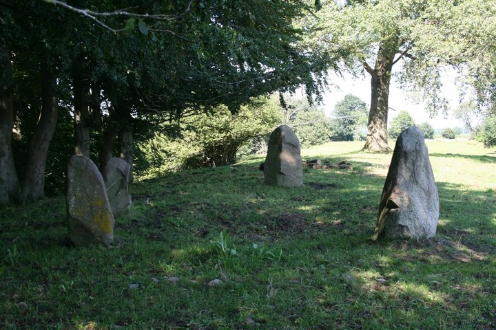
About as close to a ‘proper’ stone circle as you get on the Isle of Man, this was high on the list of sites to visit during our trip.
Heading back up to Port Erin after a visit to the lovely Cronk Karran hut circle, we took an unlisted single track road towards Ballnahowe. Despite keeping a sharp eye out we nearly flew past the pull in for the site, no signposts (not even a parking sign) indicate the muddy layby, which looks little more then a passing place in the road, only by noticing a fence and sign on the steep ridge of the hill did we know we were in the right place.
But what a place it is! A steep walk up the path to the top showed us another of Man’s unusual monuments. Six main cists form the circle, and I’m not sure whether this was once a circle that has been re-cycled into a burial place by having cairns built into the perimeter. it also looks as if there may once have been an original embankment or henge style monument here at one time, although the estimable Mr Burl makes no mention of this in his guide to stone circles.
I hunker down in one of the cists to escape the gale force winds, and now sheltered and cosy am able to write some field notes.
It’s definitely a dificult site to get a handle on, but its uniqueness lends it an air of mystery, and somewhere you must see if you are on Man. I’d love to stay longer, but the cold wind, and thoughts of lunch in Port Erin pull us on.

Gorgeous views out from the top of Meayll Hill across the Irish Sea.

View of one of the cairn cists which makes up the circle.

Panoramic shot of the Mull Circle, looking north east-ish!
In folklore the area on which the cairns sit was haunted by a huge old boar known as the Purr Mooar, which was slain by a local legendary figure known as Jack the Giant Killer, who was himself somewhat feared by the locals. The story is related in a book of Manx folktales;
‘Now there was an old boar called the Purr Mooar, that had long been a terror to the district, so much so that it was not considered safe for any one to go alone over the Rheast and through Druidale. Even the shepherds with their dogs were unwilling to face him. This purr Jack determined to kill, so he armed himself with his thickest stick and set out in search of him. After travelling a considerable distance, he made his way down to a deep glen where he discovered the boar, it being a sultry day, luxuriating in the water. No sooner id he see Jack than he raised himself up, and, with a terrible roar, rushed out upon him. Jack, nothing daunted, received him with a severe blow upon the fore legs, which caused him to roll over. Getting up again he rushed once more at Jack, who belaboured him with many a heavy blow, but unfortunately the boar managed to inflict a deep wound in Jack’s thigh, which laid it open to the bone. Still the conflict went on till both were well-nigh exhausted and faint from los of blood, till at last Jack with one terrible blow shattered the boar’s head, and laid him dead at his feet. It was with great difficulty that he managed to crawl home, and it was long before his wounds, which were said to be of a poisonous nature, healed, and even then he was obliged to go about with a crutch for the rest of his life. Thus was the neighbourhood rid of two troubles – Jack and the Purr Mooar – for the one was now harmless and the other dead.’
From ‘Folklore of the Isle of Man’, by A.W.Moore, 1891
Visited 7th March 2012
On high, wet moorland, the Druidale cairns form part of an area rich in ancient remains. Several hut circles are nearby and medieval shieling sites are also evident. The area on which the cairns stand is known in Manx as ‘The Rheast’, which means ‘waste or moorland’.
Two cairns are evident here, comprised of large white quartz stones, they stood out like beacons overlooking the road as we drove down the C37 through Ballugh glen.
Pulling in at the car park at Montpellier Wood we set off walking up the footpath leading up the hill in front of us. The walk up is nice and wild, almost like walking up a stream due to the water draining off the moorland down the path, the decision to wear wellingtons proving to be a wise one.
Up here on the blowy, waterlogged moors of Druidale it feels like the Scottish highlands. The sun is out after last nights rain, and even the wind isn’t as bitter as yesterday. I’m perched on the quartz blocks of the cairn, which stand out brightly against the dull colours of the moor.
The southerly cairn is the largest, although much of the cairn material is buried, the circumference of the cairn is still visible and from where I’m sitting the outline of the cairn stretches around me, further quartz blocks hidden under the grass. Apparantly this cairn was excavated in the 19th century by a Canon Quine, who employed labourers to dig into it. A burial urn was discovered, which unfortunately was dropped by one of the labourers and broken, and no traces of this artefact now survive.
Around 20’ to the west of the southern cairn lies a fallen standing stone, now partially sunken into the marshy ground. A couple of feet of the stone are visible, but it is difficult to tell how high the stone would have stood when erect.
The northern cairn is more robbed and interfered with, the remaining stones being particularly piled up, probably by walkers, and now it merely looks as if a group of boulders that has been piled up from the main cairn
The wind continues its steady gusts but it’s been a fine walk to the cairns, and I’m glad we took the opportunity to see these lovely quartz cairns.
Visited 6th March 2012
Heading down the A2 from Ramsey to Laxey after a visit to Cashtal yn Ard our intention was to pay a visit to King Orry’s Grave, and spotting a brown sign indicating that monument we took the right turn onto the B11 as directed.
The lane was narrow as it passed through the village of Ballaragh, but shortly Ellen spots the Spiral Stone at the side of the road, the green sign perched above it standing out like a beacon. Pulling into the side of the road, there really isn’t anywhere proper to park, but the road is so quiet we risk leaving the car and head over to the stone.
Without the green sign to indicate its presence you would most likely never spot the stone, as it looks like nothing more than a boulder wedged into the fieldwall, and it’s hard to know whether once this would have been a standing stone, or just a rocky outcrop that the Ancients decided to carve.
It takes a bit of spotting but soon we discern the shape of two spirals, and possibly also some cupmarks, towards the bottom of the stone. Trying to make them out with any clarity is difficult so I rumage in the car for any water to damp the stone and try to make photographing the spirals easier. After a libation of sacred lemonade (the only liquid I could find in the car!) things become clearer and I have a go at photographing the carvings. Two spirals are definitely still there, but the third one does now seem eroded to the point of occlusion. Still it’s been nice to happen upon this stone at the side of the road, and so close to our intended destination!
Visited 5th March 2012
This really is the most idyllic location for a site, I’m blown away (and not for once by the incessant Manx winds).
We initially found it tricky to find, no signposts indicate its presence, and there are a maze of little lanes around the village of Cregneash. We took a narrow left turn just after the village car park, heading towards the coast, having spotted a sign to ‘The Chasms’. The lane soon ended near the cliff tops at a bumpy car park. Heading towards the old cafe building, now just used as a shelter, we opened the gate and entered the chasms.
They are well named, as yawning gaps litter the area. Picking our way through them we initially head left, (as it turns out the wrong way!) and spend about twenty minutes clambering around and trying to find the site. Eventually after heading back the other way we spot the circle and work our way down to it.
Now the sky is a gorgeous blue and it’s wonderfully sheltered here at Cronk Karran. I’m sitting in the circle listening to the call of the gulls and watching the sun sparkling on the sea.
Although there is some argument as to whether Cronk Karran is a cairn circle or hut circle, to me it clearly feels like a dwelling place rather than a site of burial or ritual.
One section of the wall is double skinned, but this only extends for around six feet and has clearly defined ends. It reminded me of the stone beds built into the houses at Skara Brae on Orkney, and I wonder if it was used for this purpose here? Certainly after reclining in it for a while it was just large enough for me to stretch out fully, and in the warmth of the sun, on the relatively soft grass, I’m almost dozing off.
After reading Kammer’s fieldnotes I had high hopes for this site , and it doesn’t disappoint, it’ll be hard to tear ourselves away. Cronk Karran is a definite must visit if you are on Man.
It seems that the Giant’s Quoiting Stone may once have been part of a pair of stones, Samuel Lewis writing in 1831 states,
‘In this parish are the small villages of Port Erin and Port-le-Mary. Between these villages are the Giant’s Quoiting stones, two huge masses of unhewn clay-slate, about ten feet high, three feet wide and two feet thick. Within a mile of these is Fairy Hill, a barrow situated in a low morass from which two defiles lead to Port Erin bay and the creek of Fleswick: the hill is a truncated cone forty feet high, and one hundred and fifty yards in circumference, completely surrounded by a deep and wide ditch; on the summit is a circular excavation ten yards in diameter, with a regular parapet; the sides of the hill facing the defiles are almost perpendicular, and on the north-east side a a pathway to the summit is discernable‘
From ‘ A Topographical Dictionary of England’ by Samuel Lewis 1831 vol 3, p230.
The Fairy Hill mentioned seems to be marked on the modern OS map as a ‘Motte’ just to the north east of Port Erin (SC205 696). The other Quoiting Stone is said to have stood on the slope of Cronk Skibbylt behind Cronk Road.


View of Cronk Karran on the approach through the chasms.

Looking north-west from the southern section of the circle.

The double skinned section of wall, or a Skara Brae style megalithic bed?


Looking across the Cronk toward Black Head.


