
The hut circle of Cronk Karran perches right on the cliff’s edge.
Image credit: Paul Kesterton
The hut circle of Cronk Karran perches right on the cliff’s edge.
Visited 5th March 2012
A very urban standing stone, this menhir must stand a good 10’ tall. We passed it as we were heading down the A31 on our way to Castletown. I was a bit taken aback by the size of it, and how closely it stood across from the houses on Beach Road in Port St. Mary.
Parking in a small residential cul-de sac opposite the site we spotted two gates into the field, one of which, in the corner of the field between the A31/A5 junction, stood wide open, invitingly beckoning us into the field.
This huge stone is lovely, we sheltered in the lea of it from the unrelentingly bitter wind that seems to have blown incessantly across Man since we arrived.
It was nice to take a bit of time to stand with the stone, the huge empty field streching off before us. I was possibly expecting some curtain twitching from across the road, but either everyone was out or else they are just unperturbed by a couple of old hippy stonehuggers. The dark band on the stone described by Kammer had faded down to be barely noticable, but since the stone’s beard of moss only seemed to cling to its upper half I’m sure cattle still enjoy using the stone to scratch their itches.
One of the finest standing stones on Man, nicely accessible, it’s a lovely stone, and we didn’t feel unwelcome entering the field. This one is a must visit if you are near Port St. Mary.

Shadow people at the Quoiting Stone!

Blue skies over the Giant’s Quoiting Stone
Visited 5th March 2012
When is a burial chamber not a burial chamber? Arguably when it’s been dug up, partially destroyed and re-erected in a different location opposite a church without any of its previous context.
I don’t want to sound too harsh to the poor Ballaharra stones, as I’m generally in favour of restoration/reconstruction of ancient sites. But the four remaining stones here seem to have been reconstructed almost as a garden feature, by the same token if I collected some stones from a cairn on a windswept moor and piled them up at home would I have a megalithic site in my garden? The stones may come from the monument but the monument itself is long gone.
Still the stones themselves are pleasant enough, with two small trees bookending the site, although the proximity to the busy (for the Isle of Man) road spoils things a bit, as does the litter accumulating near the garden wall. Due to the reconstruction it is difficult to tell how the burial chamber would have been structured, since two of the stones were destroyed during its ‘excavation’ but it looked as if one of the stones was possibly cupmarked.
The information board, with its Stonehengesque delusions of grandeur, is still there but looking a bit faded now. We took a few photos and retired to the very good Tynwald Hill cafe for a drink in front of their lovely open fire.
Visited 3rd August 2011
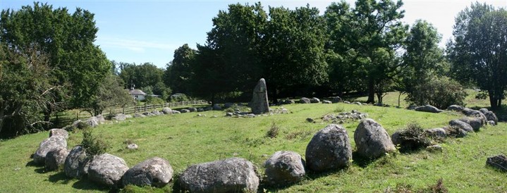
The Kivik bonus site! In English Penningagraven means ‘Coin Barrow’, as there was supposed to be treasure buried within it. It’s a very fine site within the larger grave field of Ängakåsen, and it’s amazing how much of this Bronze Age cemetery remains, and how little visited it seems considering its proximity to the Kungagraven.
The kerb circle itself is comprised of nice chunky boulders and the battered central standing stone, which was once broken into three pieces, has been neatly stuck back together (no ugly iron banding here!). Two cult houses (’kulthus’ in Swedish), smaller kerbed burial cairns, stand just to west of the monument, whilst another can be found actually inside the Penningagraven itself.
Without the trees which screen the site there once would have been views from Penningagraven out across the Baltic to the north.
It’s lovely and peaceful here, and this is an amazing place. As I sit on the stones in the blazing sun I can just catch a glimpse of the shimmering blue Baltic through the trees, butterflies flutter around me and I’m lost for words in the magical atmosphere here. It’s like being a kid in a megalithic sweetshop! Even the cows across the other side of the field are placid and chilled out by the atmosphere!

Panorama looking south across the Penningagraven.
Panorama looking north across the Penningagraven.

Looking towards the kerb circle. These two stone rings are known as ‘kulthus’ or cult-houses, thought to have been used in ritual ceremonies, another can be found in the kerb circle itself.

The central standing stone in the Penningagraven had been broken into three parts many years ago but has been sympathetically stuck back together, the joins are visible on the photograph.

View across the steam separating the two sites on the Angakasen burial field.

The kerb circle of Penningagraven, as seen from just over the stream from the Angakasen skibssaetning.
Visited 4th March 2012
Parking up in the small village of Ballugh outside the church of St Mary, the bells were calling the faithful to Sunday morning service, but we were in search of a place of older gods...
Taking the footpath opposite the church a pleasant walk down a tree lined path takes us over a stream and soon the asphalt lane becomes a mud track, with high gorse hedges shielding the fields. The OS map indicates the stone will be to our left, but the embanked gorse makes it maddeningly difficult to see anything.
Soon however a conspicuously trampled path up the bank where there is a gap in the gorse allows me to spot the stone. There is no sign of any gate into the field, but with the Ravenfeather mantra of ‘It’s not a visit unless you can hug the stone!’ ringing in my head, I endeavor to clamber over the bank and fence to gain access to the field. Trying not to do myself an injury on the barbed wire I step over the low fence, but Ellen very sensibly elects to stay on the bank to view the stone from afar.
A short trek over the ploughed field brings me to the stone. Well ooh err missus! This is one of the most phallic stones I’ve seen, the bulbous bit of stone at the base (use your imagination) and veiny, ridged (for her pleasure) sides, adding somewhat to the effect, and not for nothing is it known as ‘Mannanan’s cock’. It must be around 6’ in height and fairly chunky. A fine and unusual stone to visit, it’s just a shame the field it stands in isn’t more accessible.

Taken on 4th March 2012. The gorse hedges in the background hide the footpath we approached the monument on.
Visited 31st December 2011
Of all my many previous visits to Anglesey I’d never been here before. Despite being only a stones throw from Barclodiad-y-Gawres I’d always found the maze of lanes around Llanfaelog confusing, or maybe I’d been subconsciously avoiding seeing the appalling restoration of the dolmen, now with an OS map in hand there were no excuses so we set off to view the site.
Initial impressions were hopeful, as we parked up in the tiny layby outside Ty Newydd’s field, the shape of the huge capsone hove into view and I thought well that doesn’t look too bad. Indeed from one angle it doesn’t, but as you approach the true horror of the restoration becomes apparent.
Oh dear.
Looking more like a dodgy garage extension than a serious attempt at archaeological restoration the brick pillar ‘supports’ are so inappropriate as to totally ruin the form of the monument, and I desperately try to angle my photos to hide the ugly brickwork.
Well done to the 19th century gaping rustic who lit a bonfire on the capstone cracking it and necessitating this later awful reconstruction. I’m generally in favour of restoring megalithic sites but to be honest this one would have looked better if it had been left in a tumbledown ‘dolmen on a blasted heath’ type state rather than having been used as bricklaying practice for the Ministry of Works. Surely it would now be possible to restore the monument in a more sympathetic way?
If you can overlook the bricks the dolmen is of a good size, the capstone being impressively huge. I was initially perplexed by the small concrete posts which surrounded the structure, before figuring out that they indicated the circumference of the mound which would have once covered the dolmen (at least I think that’s what they’re for, please someone correct me if I’m wrong!) At least from one angle it looks great, like a perfect stone table, perhaps I can dream that one day someone will come along and restore it properly!
Visited 1st May 2011
A lovely sunny spring day on our way down to Portsmouth and the ferry to Brittany. I’d looked for the Thor stone before on previous trips down to the Rollrights, but was always confused by the maze of lanes.
Now with the sat-nav taking the strain we pull up in the tiny village of Tatston. Managing to park near the old stone cross on the green without blocking the roads, (a feat in itself) we have a wander over to examine the stone.
The stone is a good size, and reminds me of the oolithic limestone that makes up the Rollrights, but less holey. It seems indignant to the proximity of the nearby wall, like it’s trying to peer over into the garden. The village is quiet today, it seems to have a bit of a ‘Midsommer Murders’ vibe to it, and no cars come by to interrupt my photographing of the menhir. It’s nice to see that the Thor Stone seems to have weathered the centuries better than the stone cross set up to ward off its evil influence!
Giving the stone a Beltane hug we leave to continue our journey, if you’re in the area the Thor stone, Hawk stone and Hoar stone can all be easily visited being quite close to each other, and I’m glad we finally managed to explore this corner of megalithic Oxfordshire.
Visited 3rd August 2011
We fortuitously found out about this site after browsing through an interesting guidebook on the Kungagraven over a coffee at the lovely Cafe Sågmöllen next to the Kungagraven in Kivik. Leaving the car in the Kungagraven carpark we set off walking east along the road in the glorious sunshine.
Only 300 metres away from the Kungagraven, and nestling among neatly tended apple orchards, we didn’t see one vehicle on the way there, nor encountered any other visitors, and after a five minute walk a small gate at the side of the road afforded an easy entry to the site.
The skibssætning itself is a large one, and has two stones set inside the boat setting, almost as if they represented rowing benches for ancient viking mariners. It also had two stones standing at the ‘prow’, these two features being different from any of the other skibssætnings we have seen. The stones also look as if they stand on a slightly raised mound, which of course may have diminished in height over the millenia, there is also a noticable sunken entranceway which points directly east into the skibssætning.
Ängakåsen itself is part of a bigger gravefield known as ‘Koarum’ remains of which are visible in the field. Almost bisecting the area to north of the skibssætning was a pond and stream, possibly a result of waterlogged ground, but it provided a picturesque backdrop across which the other megalithic remains could be seen. From the skibssætning looking north the kerb circle and standing stone of the ‘coin barrow’ beckon to us.
So I do my usual mad photographic spree of attempting to take pictures from every possible angle of the stones, whilst everyone else chills out in the peaceful atmosphere. Again I’m struck by how well kept the megalithic sites in Sweden are, the field is neatly tended, easily accessible and with nary a piece of litter, not even a fag butt, to be seen.
This whole area around Kivik seems to form part of a larger ritual landscape, almost like the Kilmartin valley in Scotland, I’m so glad we stumbled on this hidden gem.


Inside the stones, looking down towards the ‘rowing bench’ stones.

Panorama showing the length of the skibssætning. The kerb circle of the ‘Coin Barrow’ can be seen in the background, just across the river.
Visited 3rd August 2011
the Kungagraven is Scandinavia’s largest known burial cairn and therefore was a must visit on our trip to Skane.
Having read about the site and seen the pictures in The Megalithic European, I was worried this site might be one of those over-restored tourist trap kind of places, but I needn’t have worried. We arrived at 10am, just as the place was opening and had it to ourselves.
The low cairn is huge, probably the largest I’ve ever seen, but so denuded from hundreds of years of being robbed for building materials. The curved entranceway was put in during the restoration work in the 1930’s along with the gated doorway and ‘crypt’ containing the cist, but even with this modern meddling the sheer scale of the place allows it to retain its grandeur.
Inside the cool darkened chamber the decorated cist slabs seem to glow in the artificial light, the symbology showing sun wheels and burial rites, the style reminiscent of neolithic cave painting, although this tomb was constructed during the Bronze Age. The preponderance of axe heads painted on the slabs reminds me of the carved axe head symbols I’ve seen in the tombs in Kilmartin valley. The cist slabs were damaged during the 18th century when the quarrying was at its peak, and three of the slabs even disappeared from the site, although fortunately detailed engravings (copies of which hang in the nearby cafe) were made before this happened.
Soon other visitors start to arrive and we move from the small chamber back out to the dazzling sunshine for a wander around the outside of the cairn.
Near to the cairn, where you pay for your entrance tickets, by a murmuring brook, is the picturesque Cafe Sagmollan, where we sat for a very nice cup of coffee and I was able to write up my fieldnotes, Ellen also discovered for sale a great little booklet with information on the Kungagraven in English, and even better after leafing through it we discovered that less than 300 metres south of the cairn was a large gravefield with a number of stone settings! An unexpected megalithic bonus that we could head off to explore.
Overall the Kungagraven has been well worth a visit, reasonably priced at 20kr (about £2 when we went) and not in any way ‘in your face’ touristy.

Centuries of quarrying have reduced the Kungagraven to a third of its original height.

This slab has the depictions of two axe heads above the symbol of the sun wheel.

This slab shows horn-blowers and drummers, and underneath them probably a depiction of an act of sacrifice.


The huge cairn of the Kungagraven is Scandinavia’s largest.

Visited 20th August 2010
Parking up next to a couple of camper vans we set off to find our third recumbent of the day. After a bit of poking about in the woods (at least I’ve got the O.S. map with me today!) we found what we were looking for and what a cracker it is!
On first sight I missed the recumbent, and thought this was a ‘traditional’ style stone circle, which would have been unusual for Aberdeenshire, but soon the dumpy recumbent boulder with one erect and one fallen flanker became apparent.
Sitting in a sylvan glade this lovely little circle has a fantastic atmosphere, although close to the road, and with several campervans about, it still feels remote and separate, although the remains of a campfire in the circle suggest that it is well visited.
After earlier showers the sun is shining again, the light lancing through the trees and dappling the circle with shadows. I prop myself up on the recumbent to write up my fieldnotes, with only the sounds of woodpeckers from the surrounding forest for company.
The recumbent seems to have the same south-easterly alignment as other RSC’s but as has been mentioned this site doesn’t seem to fit the standard pattern of the Aberdeenshire circles!
Out of all the recumbent circles we’ve seen this week, this one has the best atmosphere, the whole setting of the place is like a scene from a fantasy story, the creaking of the nearby trees like the whispering of Ents. Such a beautiful circle, though hopefully we will get the chance to see a couple more before we have to return to Muggleland (the midlands) tomorrow.

Taken 20.08.10. Looking across the circle towards the dumpy recumbent boulder

Taken 20.08.10. The sun was shining through the trees giving a lovely dappled light in this peaceful circle.
Visited 31st December 2011
The sun is out, turning the sky blue as we arrive at this pair of dolmens. Again another site I’ve not visited before, despite many past visits to Anglesey, and this was top of my list to see this time. Unlike nearby Ty Newydd the dolmen here now stands proud alone, I’m so glad the ridiculous wooden truss had been removed. I squeezed under the capstone of the southern chamber, trying not to get my feet too wet in the huge pool of water which had puddled in there, and putting my faith to the test that that wooden truss really was never necessary.
Two dolmens for the price of one can’t be bad, although the northern chamber is now just a jumble of stones. It feels like the dolmen of elemental water here, being near to a lake and standing on very waterlogged ground, but it has a most warm and welcoming atmosphere, and not just due to the improving weather!
I’m not sure if this would have been one large mound with two chambers, or just two neighbouring smaller cairns, without archaeological evidence its difficult to say. The vague construction date (according to the sign it was built some time within a 2,000 year period!) also may allow for the possibility of it being a multi phase monument.
It’s certainly a special dolmen in fine pristine surroundings, its just a shame the trees screen the view of the nearby lake. Still a great place to spend some time on a lovely New Year’s Eve.
Visited 2nd January 2012
Stopped off to see this beauty on the way back from our New Years stay on Anglesey.
Not as difficult to park as I feared, there is a small layby (well probably a passing place!) up the lane, but we took Postman’s advice and parked at the field gateway.
The field was extremely soggy after the recent rains and whilst everyone else took the sensible option and photographed the stone from the gateway I picked my way ankle deep in mud into the field. (Well its not a proper visit if you can’t hug the stone!)
Up close the stone is impressively tall and its elevated position looks out like a sentinel towards Snowdonia just across the straits. The wind was whipping up as I huddled up against the stone to avoid some of the bitter chill, and as the clouds scudded across the sky the sun sent fingers of light lancing down over the mountains. It’s a fantastic setting for a stone, and well worth the visit, I didn’t want to leave.

The stone of Plas Cadnant looking out towards the sunbeams poking through the clouds.

Visited 2nd August 2011
Disa’s Ting is a rectangular setting of sixteen stones, which were erected on a small earthen bank delineating an area of thirty-six metres long by sixteen metres wide. Where elsewhere the stone setting could be described as a cromlech, in Scandinavia these types of monument are know as thing-vollr, a law centre or ‘field where an assembly meets’.
The sixteen stones range in height from 7’ tall, in the south-east of the rectangle, to around 1’ high, the largest stones standing along the southern quadrant closest to the sea. There does not appear to be any graduation in the height of the stones.
Excavations in 1920 discovered a cobblestone framework was laid down in order to form the foundation for the earthen bank, and amongst this material were found scattered burnt human bones. These were interpreted as being the remains of an Iron Age grave that would have dated from around 500 BCE to 400CE, later carbon dating has put this towards the earlier end of that scale. The embankment on which the stones stand has now denuded over time, but is still visible, and provides an opening to the enclosure from the west.
Although the archaeological evidence recovered points toward the Iron Age, and therefore long after the rest of European megalithic culture, the surrounding area is rich in earlier Bronze Age remains, including a barrow field (graberfeld) only a few hundred metres to the west, indicating that the site may have had an earlier date of construction and had been adapted for later use, as has been seen at other megalithic sites present in areas of Viking culture.
I’ve had an evening of paddling on the beach only feet away from Disa’s Ting, and even at 8.30pm it is still warm, so I waded into the Baltic at the nice little beach at Svarte, only three miles away from the house where we were staying. Then I walked barefoot to the stones as evening fell, sitting in the middle of the thing-vollr and just relaxing in the atmosphere.
Although so close to the edge of the village, with houses just a stones throw away, it doesn’t feel overlooked or unwelcome here. In fact the whole history of the site as a law centre makes it feel an integral and organic part of the village, rather than humanity encroaching on the wildness of the places where megalithic sites usually stand.
It’s also interesting that this is a very young site in megalithic terms, only 2,500 years old, although I get the feeling that the site was used by an earlier culture and adopted later by the Vikings as a powerful place to make pronouncements. As I sit in the middle of the stones, the spiky grass jabbing at my feet, I also ponder on who the enigmatic maiden Disa was. Was she a volva or seidr? It’s nice that the place is still associated with her name.
Now as the sun sets the light over the stones and the view out to sea is exquisite, before
I sat down I hugged one of the stones and was suffused with warmth, although this was a physical rather than spiritual effect, as a result of the days heat radiating from the stone, although it still feels lovely!
It’s magical to be here at sunset, with the light low over the stones, and the normally busy coast road now quiet. This was the first megalithic site we visited in Sweden, and it feels special, a good introduction to the wonders of Skane!


Visited 4th August 2011
The Gladsax bonus site! After the trials and tribulations of finding the main Gladsax site we happened upon the handy information board back at Rosadala farm. Helpfully written in English (I love Sweden, why can’t all countries be as accessible for megalith hunters!) it indicated that another ganggrift lay about 500 metres nortwest, and had an astonoshing 223 cupmarks on it!
Excited by the thought of another site in such close proximity we set off along a dusty path visible across a field to the north, and handily highlighted by a couple of small flags. Not having any idea of what to expect we scanned the horizon in the blazing sunshine, before spotting something up on a ridge ahead. Shortly the path came to a wire fence which we cautiously approached (electric fences being very popular in these parts!) but helpfully this one has a couple of insulated handles which let you detatch the bungy-rope like wire and allow access to the field.
Up on a low ridge was the unmistakable remains of something meglithic, just to the other side of another dividing fence (this one accessed by a proper gate however). Inside its field Gladsax Norre Vang was within another small fenced enclosure, probably to protect it from use a rubbing post for the inquistive herd of cows which thronged near it. After our encounter with the killer cows at Gardlosa earlier in the week Ellen decided discretion was the better part of valour and so remained in the nearby field while I had a poke about the stones.
A couple of huge capstones covered the tumbledown remains of the passage, which seemed to have been built upon a low mound, with a surrounding kerb of smaller stones, around which about half still remained. Although it lacked the impressive quartzite boulder of its near neighbour, it did have a heavily cupmarked flat capstone. This was the stone with the advertised 223 cupmarks, although many were now eroded and difficult to make out. I started to count them but was aware of the attentions of my bovine onlookers who seemed to be straining to see what I found so interesting about the site, so eventually I admitted defeat and after trying to take some photos without getting a load of cows in shot I decamped back to the next field with Ellen to write up the fieldnotes.
Gladsax Norre Vang seems to share a similar construction to its neighbour, and I imagine would probably date from around the same time, although I haven’t been able to find out any further information on the site, from its slightly raised position it is also possible to see the white gleam of the Gladsax Ganggrift capstone boulder 500 metres away, so perhaps this whole area was once dotted with funary monuments. Whatever the case was this was an unexpected joy, the two sites set in beautiful farmland on a glorious summers day, and if you ever get the chance to Gladsax then do, and don’t neglect to make the short walk to this site as well because it’s definitely worth it!

Although less intact than its nearby more impressive neighbour, Gladsax Norre Vang shares a similar construction.

There are supposed to be over 100 cupmarks on the capstone, but being harrassed by a herd of inquisitive cows I didn’t stop to count them all!

The tumbledown entranceway to Gladsax Norre Vang.
Visited 4th August 2011
Another gloriously sunny Swedish day and we thought we would try to tick off the last few sites in the Sweden section of the Megalthic European, so with Ellen driving I sat with the big papery Megalthic European open on my knee as we set the satnav for Gladsax.
Following Mr Cope’s directions we drove down an increasingly rough track at the side of Rosdala farm while I scanned the edges of the road for the ‘large boulder’ mentioned in the directions. Looking up I just noticed a glinting in the road, and just had time to shout ‘Stop!’ as Ellen slammed on the brakes and we came to a halt in a cloud of dust mere centimenters from a thin double length of wire strung across the road fencing off the track.
With frayed nerves we backed up and parked the car whilst I set off across a field to a ridge to scout out if we were anywhere near the elusive site. On reaching the ridgeline I could see the large white boulder which tops the ganggrift glinting tantalisingly in the sun on the other side of a nearby wheatfield.
Not having travelled 1000 miles to be this close to the site I refused to be deterred and taking advantage of the Swedish custom of ‘allemansratt’ (oh how I love Sweden!) I set off carefully around the edge of the wheatfield careful not to damage any crops.
What looked a short distance in a straight line was a considerably longer walk as I skirted the edge of the field, but finally the field was circumvented and I reached the huge boulder topping the mound.
As I approached the entranceway the first thing I noticed was a clearly defined path leading from the farm up to the ganggrift! So having established there was easy access I followed the path to see where it came out. Ending in a small place for parking, along with an information board I thought I’d go back and fetch Ellen who had stayed in the car so we could spend some time at the site, so after a long circular walk back down the dusty lane past head high corn, which along with the midday heat put me in mindof the American midwest, I finally made it back to the car.
So trying again we now drove to the farm and parked up. Giving us a bit of time to examine the site and take in the atmosphere, and what an atmosphere there is here!
Gladsax (alsoknown as Stenstuan) is currently the oldest confirmed Neolithic site in Sweden, cremated remains and pottery from inside the structure having been carbon dated to around 3,700BCE. A circular kerbed wall of small stones has a mound constructed on top, with a small row of low stones defining an entranceway, and leading to a tiny burial chamber. Topping this off is a huge quartzite boulder. Technically this could be classed as a ‘langgraff’ or long grave, but the entranceway is so short, and the construction of the monumnent so different to others of that type that it doesn’t seem to fit.
There are some excellent carvings on the boulder capstone, some clearly defined as boats, while others more abstract, I went around furiously photographing them, although the high sun made it difficult to pick out the the detail with little shadow to define the carvings, but the pictures seemed to come out OK.
Then a chance to sit down at the site and write my fieldnotes. It is perfectly quiet here, the atmosphere distinctly ‘Lammasy’ with cornfields dotted around, and a wealth of wildflowers covering the field in which the ganggrift stands, as well as countless butterflies everywhere, we even saw some Large Blue’s!
The perfect bucolic setting and preponderance of butterflies adds to the magical fairy mound kind of quality that this place has, the tiny burial mound is too small to squeeze into but if I did I wouldn’t have been suprised if hundreds of years had passed by the time I emerged! We felt happy here and reluctant to leave, Gladsax exerting it own pull on us, this really is a place you need to visit as pictures don’t do it justice.
Directions: Follow Julian’s directions in the Megalithic European as far as Rosdala farm, but instead of taking the suggested track at the side of the farm instead drive down the farm access road past the line of trees and you will see as you approach the farmyard a small information sign ahead of you, along with a small area to park. Just to the right of the sign (it looks as if it gives access to the farmyard) you will see the start of the path leading to the ganggrift, and the site itself will be visible as it’s only a short walk. You can also folow the track across the adjacent field which leads staright ahead where you park the car which will lead you to the more ruinous site of Gladsax Norre Vang, which is just across the field on a low ridge, directly to the north of Gladsax Ganggrift.

The entranceway into the tiny chamber of Gladsax Ganggrift.

Side on elevation, showing the incongruously large capstone with the kerbed mound.

Approach shot of the site, the cornfield is the foreground had to circumvented (as I hadn’t found the proper path by this point!) leading to a long walk!


Close up of the ‘boat’ carving on the capstone.

The capstone boulder at Gladsax is covered with rock art.

The Gladsax dolmen, showing its small kerbed entranceway.