Ravenfeather

Ravenfeather

All posts expand_more 501-516 of 516 posts

Havängsdösen

Visited 3rd August 2011

This is probably the most comfortable dolmen in the world! Soft sand to sit on, a glorious view of the Baltic in front of me, and a chamber just my length to recline in. Nice and easy to find, we followed Julian’s directions in TME, parked up at the busy carpark at Havang, and headed for the beach!

The sun is hot today, but with a cooling breeze from the azure sea, we have just had a picnic by the dolmen, within the sheltering enclosure of the surrounding stones. The beach front setting of the monument is idyllic, and although there are plenty of folk around it is not crowded. People come and go at the stones but do little to disturb the feelings of peace.

Havangsdosen was discovered after a heavy autumn storm in south eastern Skane in 1843 blew away sand covering this 5,000 year old grave. The monument consists of a small dolmen, with a large capstone supported by three uprights forming a burial chamber, but seems very different from the British or Irish dolmens that I’ve seen, in that it is surrounded by a rectangular setting of sixteen stones.

The name of the site ‘Havängsdösen’ means “The Dolmen on the Sea’s Meadow” and it is aptly named, being on the edge of the sand only metres from the sea. In Skǻne, the southernmost county of Sweden, it seems common for Neolithic graves to be sited along the coast and larger rivers.

The entrance to the burial chamber itself looks out east across the Baltic, and is aligned in such a way as to be oriented with the sunrise on the Vernal and Autumnal equinoxes, the sun rising from the seahorizon illuminating the chamber for twenty minutes during these equinoctial sunrises.

I’ve spent some time relaxing in the comfortable enclosure of the chamber and gazing out over the clear blue sea can only imagine the magical qualities of seeing the sun rise up directly in front of you, bathing the chamber in light, it gives you a sense of the reasons why the ancients built these monuments how and where they did.

This was one of the sites in Sweden I was most looking forward to visiting and it doesn’t disappoint!

Er Lannic

Visited 4th May 2011

On the islet of Er-Lannic in the Gulf of Morbihan on the south coast of Brittany, lie the remains of two cromlechs. Originally they would have stood on a small hillock on the mainland, but as sea levels have been steadily rising for the past 7,000 years they have now become partly submerged, Er-Lannic having been cut off from the mainland since Roman times.

The northern site is a flattened circle, which would have been comprised of up to 60 stones, the stones standing almost contiguous with each other, similar to a kerb circle, but being much larger stones than are typically seen in that type of monument, ranging in height from 6’ up to 17’ 4”. There were also two tall outliers to the east and west of the northern circle, in line with the tallest stone in the ring, both of which are now submerged.

The southern site is horseshoe shaped, and is now completely submerged, it has a diameter of around 200 feet, with an opening to the east. It was first discovered in 1872 when Closmadeuc, an archaeologist from Vannes, visited the north ring at very low tide and noticed the tips of some more stones exposed above the sea. At the southern tip of the submerged cromlech there would have been a gigantic stone pillar, called ‘men-ar-gou’ or ‘La Roche du Forgeron’, meaning ‘the blacksmith’s stone’ by fishermen.

Le Rouzic excavating in the 1920’s found around each stone a cist containing charcoal, animal bones, worked flints, pottery, and a lot of polished axes. Two stones are carved with axes and a yoke, and one of the uprights’ packing stones has nine cupmarks (according to Le Rouzic, arranged to form the outline of the constellation Ursa Major). A plan was also made of the submerged site, documenting the layout of the southern horseshoe, and detailing a possible three sided and unroofed Cove within the submerged south-eastern section of the north ring.

Burl suggests there are possible alignments within the monument to astronomical events, (p. 256 ‘Guide to the Stone Circles of Britain, Ireland & Brittany’ – Aubrey Burl 1995) and that lunar alignments with the major northern moonrise and moonset could be drawn along the South-East to North West axis, which aligns directly between the tallest stone in the northern ring, and the submerged cove.

When Aubrey Burl said this one was ‘very private’ he wasn’t joking! Although I don’t like making fieldnotes unless I’m actually in the site, with Er-Lannic this is as close as I’m likely to get without my own boat. Taking the last trip of the day to Gavr’inis was a lovely end to a day of megalith hunting, the last boat trip to that amazing cairn also comes in close to Er-Lannic. It seems so strange to see the stones protruding from the sea like a sunken ruin, you can only imagine what the scale of the monument as a whole would have been like when it was intact.

I first caught sight of the huge pillar in the northern ring when we were on Gavr’inis waiting to enter the cairn, and Er-Lannic seemed tantalisingly close across the immensely fast flowing current separating the two islands. As we came in closer more stones in the cromlech became apparent, all seemingly providing handy perches for the resident sea birds. Ellen took photos as I struggled to keep the video camera steady, and avoid too many of our fellow boat passengers getting in the way of the shots!

Although it’s now a bird sanctuary I’d still love to set foot on the island and stand amongst the stones, their power seems undiminished despite the advance of the sea. Although bobbing nearby in a motor launch full of tourists is not the best way to soak up the atmosphere of a site, on Er-Lannic it reaches out to you and is irrepressible, a partly sad, partly foreboding feeling of an isolated place, the cormorants perched atop the stones like shadowy guardians warning away visitors to this sacred enclosure.

The Stoup

Visited 11th June 2011

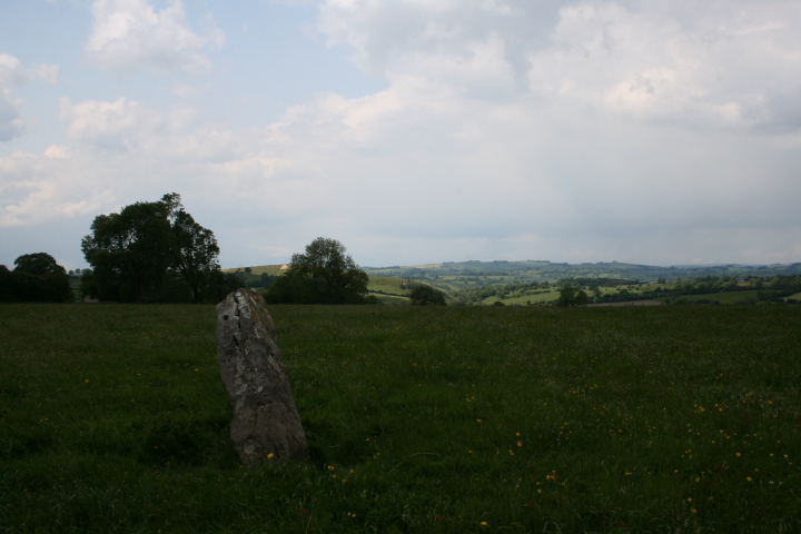
Another Derbyshire daytrip on another sunny day. We’re visiting a couple of standing stones just outside Ashbourne, some of the closest ancient sites to where we live, but I never even knew they existed until recently. The Stoup was refreshingly easy to find, visible from the road, standing proud in its field, although leaning at such a dangerous angle it look as if it’s about to keel over at any minute!

Cupmarks are clearly visible on one side of the stone, they look a little too regular to me to be natural, which only reinforces my belief that this is a Neolithic, rather than Saxon monument. Also interesting is the way that the incised cross is carved on the same side as the cupmarks, maybe the cupmarks were seen as having pagan symbolism even in Saxon times, and this was an attempt to ameliorate this?

There is a lovely view out to the west, with the lean of the stone pointing towards the distant hills, and the meadow the stone stands in is dotted with flowers. A nice spot to sit and contemplate, if only the wind weren’t so fierce, so time to press on to the pub in Cromford I think!

Devil’s Quoits

Visited on 17th April 2011

We’d been thinking about visiting this site for a while, so it being a gloriously sunny day we thought it’d be nice to take a trip down to Oxfordshire.

Nice and easy to find, just headed for Stanton Harcourt and followed the signs for the landfill site. Parked off at the first available layby (fortunately no problems were encountered from officious men in hi-vis jackets) and trekked off around the lake looking for the stones.

Well you can’t really miss them as you get near, a huge embanked henge dotted with twenty-eight satisfyingly chunky large stones. The henge has the classic entranceway leading into and out of the circle, and it looked like there was an outlying stone to the south.

The stones themselves are of a strange type of local conglomerate rock, which looked as if it was about to come apart at any moment, most of them are modern replacements, the older stones seemingly identifyable by their darker more weathered colour.

The monument itself originated as a henge, with evidence of postholes having once been in the centre, before the final phase of the erection of the stones around 2,500 BCE.

We had a picnic in the circle, the only sounds the cries of birds and the honking of the geese in the nearby lake, and the ground around us scattered in bones scavenged from the tip by the ever present birds. It certainly has a different atmosphere here, with the landfill site looming incongruously in front of you, somehow you can just tell it’s a reconstruction and not an ‘authentic’ site, even if no-one had told you so, but it is nice that someone has bothered to reconstruct the circle after all it has suffered in the past, and don’t let it put you off visiting, for it is an impressive place.