juamei

juamei

All posts expand_more 751-800 of 1,035 posts

Maesbury Castle

[visited 23/4/5] This is a delightful little fort hidden away on the edge of the mendips. I imagine the views are immense, unfortunately it was very hazy / misty on this visit and so I could only make out shadows in the mist. I could however see the Pen Hill transmitter & hill in the near distance, though I suspect the barrow is hidden over the crest of the hill from this angle.

Condition wise this is ok, though the banks are somewhat denuded & I suspect this site has been ploughed in the past. There are also a couple of points where the bank could have been levelled. On the West side is what looks like the remains of a cobbled entrance, which if true, makes this somewhat strange. That said evidence of wheeled vehicles have been found not too far away at the glastonbury lake village.

Accesswise, I parked just off the road to the South of the fort and followed the footpath over it. Its about a 5-10 minute walk up a steep bumpy field. You could possibly get to it via the golf club next door, but that way lies madness.

DNA project to trace human steps

A project spanning five continents is aiming to map the history of human migration via DNA.

The Genographic Project will collect DNA samples from over 100,000 people worldwide to help piece together a picture of how the Earth was colonised.

Full story on the beeb

Broadmayne Bank Barrow

[visited 26/3/5] I started the day by scanning the dorset map for barrows and I found this, my third Bank Barrow. There are apparently only 3 left in a decent condition anyway so beyond ripples in the mud, this may well be it. Surfice to say I wasn’t disapointed, its another riproarer, a giant amongst little people. Standing proud on the dorset ridgeway, with beautiful 360degree views and so many round barrows paying tribute to it.

The really nice thing about this is it seems to be complete, I don’t think the road builders chopped a bit off the end and fortunately any ploughing hasn’t reduced it beyond amazing levels. Comparing it with the other brutes in Dorset, it didn’t seem as large as long bredy but was definately larger than Black Down.

Access is good as a road goes straight past the field this is in and tbh you get a great view of its hugeness from the road.

Arrest Over Stone Attack

From: thisisoxfordshire.co.uk/oxfordshire/archive/2005/02/25/NEWS5ZM.html

A man has been arrested on suspicion of criminal damage to the 3,500-year-old Rollright Stones, near Chipping Norton, which were vandalised with yellow paint.

The 26-year-old has been questioned and released on police bail until March 19.

The attack on the ancient stones caused £50,000 worth of damage on April 1, last year. A £1,000 reward was offered by the Pagan Society in a bid to find the person responsible. The stone circle, which has about 70 stones, is known as the King’s Men, while another five across a field are known as the Whispering Knights. On the other side of the road is the King Stone.

They are the third most important stone circle in the country, after Stonehenge and Avebury, both in Wiltshire.

Gatcombe Lodge

[visited 4/2/5] Foolishly I failed to read the pages here before visiting this barrow. I’d allready failed to find the burial chambers in Avening and bombed straight past The Tinglestone. So as I headed back towards Avening, I passed the longstone and stopped on the verge of the track leading past this barrow.

Seeing no-one about and not really aware of the danger, I strolled to the barrow and had a good root about. 2 stones are standing at one end and one chamber is visible though almost buried. The barrow is in a bad state but better than some about these parts.

And then the landrover arrived. So I pegged it back to my car expecting an irate farmer and instead met 2 nice police officers, who ran the full police check on me as well. I was then informed that the tinglestone is on the same estate and isn’t visitable either...

So, access is prohibited and inadvisable if you have any outstanding warrants. There was no-one about when I went but they apparently have cameras and very efficent coppers. You’ve been warned.

Coate development gets government go-ahead

CONTROVERSIAL plans to turn fields near Coate Water into houses and a university campus have taken a huge step forward.

A Government report published this week by an independent panel has given the go-ahead to the divisive development.

It says that the development of the new campus for the University of Bath in Swindon along with 1,800 new house on land between the Great Western hospital and Coate Water is appropriate and provides a good basis for development over the plan period of 1996-2016.

Full story

Nb: Apparently any development has to keep the circle but presumably will change its surroundings completely.

Pen Hill

[visited 28/11/04] Apart from the Priddy henges, this is the one I’ve been wanting to visit longest in this area. I got the OS map of the area and then had to drive past the mendip main tv transmitter everyday, knowing there was a longbarrow I’d not visited right underneath it. Finally however I got to it, having picked our way across a sea of mud, the barrow is in its own little enclosure.

Its positioned perfectly, running along the crest of the hill and the view across the somerset levels is gorgeous. Of course most of the land you see now was underwater in the neolithic, but the distant hills were certainly occupied and the gods are always watching.

The barrow is in fairly good nick but is clearly denuded, I couldn’t see any sign of stones around or on it, so this is presumably an earthen longbarrow. Unless someone has nicked them all of course. I’d recommend this site, though the huge transmitter may put some people off as it really is hard to forget about it towering above you.

Access is up a metalled track to the transmitter, then round to the left, through the gate and the barrow is in front of you enclosed in fencing.

One more thing worth looking at is the weird linear feature to the east of the barrow which you’ll probably see before the barrow itself. This is the ‘bank barrow’ Rhiannon mentions. I’m not convinced it qualifies to be in the same league as the dorset ones. Its just not enough of a brute for that in my opinion, its too small in width and height.

It does however look similar to the weird tracks leading up to the Barrow above the long man of wilmington. I’d bet someone elses house on it being as old as the barrow.

Deerleap Stones

[visited 28/11/04] These caught my eye a few months ago and finally I’ve had a chance to visit. The view was gorgeous and well worth the trip to these parts all by itself, but the site itself, hmmmm. Lets start with the dead badger lying close to the stones, not their fault I will admit, but it really didn’t add to the ambience of the place, though did provide a useful comparison for the photos.

Onto the antiquity of the stones, I’ve seen a fair few standing stones now about these parts and they have all to a rock, been considerably more weathered than these two. They’ve had much more lichen and are on the whole darker. These stones stood out lighter from a distance, which is never the best of signs.

Perhaps they’ve come from a barrow hereabouts, the roundbarrows round here contain cists after all, or perhaps they are a more modern introduction.
--
Reading the site notes, one stone should defn be less weathered, presumably the upper stone as its lighter.

Access is via a 10 minute walk from one of two ebhor gorge car parks, along a road for a bit, then in a field.

Priddy Nine Barrows

[visited 28/11/04] This is really only half a barrow cluster, there being another line of barrows (Ashen Hill) 1/2 a mile to the North. One thing I noticed when up here, besides the fact its cold on the edge of the mendips in late November, is you can’t actually see the levels from here. In fact they are a touch oddly placed imo.

I presume the sight from the Priddy Circles to the North would have been unimpeded 3-4 thousand years ago and this lovely linear cemetary would have visible shining white on the horizon.

Access is across a few fields, but you can see these beauties from a fair way off in most directions (except North).

Ashen Hill Barrows

[visited 28/11/04] I’m loathe to include this as a seperate site from priddy nine barrows (PNB), but as it is seperate on other websites and an extra eight or nine barrows would make PNB very badly misnamed... However, these should almost certainly be counted as the same cemetary, being less than 10 minutes walk from PNB and highly inter-visible. But maybe then the idea of a barrow cemetary is fundamentally flawed when you are talking about barrows. Where do you draw the limits?

Moving on, this is a nice linear cluster, acting almost as a counterpoint to PNB who’s line lies slightly further to the east. They are all in relatively good order and a fair size for todays barrows. One thing that did puzzle me were the ditches either side of the barrow line expecially as the Northern ditch had large stones within it. Whether this is a mendip thing I’m not sure, there is a solitary large barrow at 545492, with 300 metre long ditches either side of it. The ditches look newer than bronze age however...

Access is a 100 yards down a track then 200 yards across a muddy muddy field.

Priddy Henges (incomplete 4th circle)

[visited 28/11/04] Yet to get into the field to have a close-up look at this, but through the hedge and the gate its little more than a ripple in the grass. The barrows in the henge are semi-visible but as with the henge, clearly ploughed out. The whole site has that fuzzy look about it. Sadly there is also a  hedge across the henge so you can’t even see the whole thing in one go.

The field containing the henge is on a country lane with 70mph cutthroughers, so if you keep your wits about you access is good as they don’t come along that often.

Pool Farm Cist

[visited 28/11/04] The lure of a concrete copy onsite lured me here, but I kinda failed to find it. I think I saw it across a field, but pain & mud put me off till the spring.

For those who are tempted in the meantime: Starting on the B road, head west to east along the footpath that goes past Pool Farm. On the other side of the first field on your left is what I think is the remains of the cist.

Access is unknown but looks like being across a muddy field.

Faulkland

[visited 28/11/04] Yet another possible trashed ancient site, I’m not that picky me, so I popped along. I counted 5 medium sized stones (4ft+) scattered on or near the village green including the two set up either side of the stocks. They certainly had the look of very weathered stones to me, covered in lichen as they were. I didn’t go looking for the cottage called “The Cove”, but I do think the evidence weighs in favour of this being the site of an ancient monument.

Access is excellent, you can park within 20 yards of the stock’s stones, on the edge of the green.

West Compton Down

[visited 11/9/4] As I was bombing past here on my way to Toller Porcorum, I stopped for a shufty. Basically its 2 (or possibly more) large stones together in a crop field. Luckily the crop was gone so I shinnied over the gate and went for a closer look. I presume this is the remains of a long barrow and in fact The Ancient Stones of Dorset has a picture from 1872 suggesting these may form two sides of a chamber. One thing is for certain not much is left to talk about. Good views though...

Access to the edge of the field is easy as its on a road, after that its a field...

Dorset Cursus (North to Martins Down)

[visited 10/9/4] Not much to see here that is recognisable really. As you approach from Bokerly Farm, the cursus is conspicuous by its absence on the right in a field where it once stood. And then in the next field where the goal should stand, Bokerly Ditch rises like a false dawn in the distance.

Now given that the remains on the map look like a C with long barrows attached, with supposedly the earthwork of Grim’s Ditch just behind, one long mound took me a bit by surprise. I contemplated for a good 10 minutes whether the elongated mound in the middle of the field was actually part of the cursus and I think on reflection it probably is. It does kinda point at the obvious long barrow on the hill to the South and does also have a couple of dips, kinda like the map.

But ffs what damage and destruction the plough has wrought here. This monument was once one of the greatest ever built and I get the feeling 200 years (or even less) ago, we would have seen something of that greatness rather than the sad remains today. This field is still being ploughed, all thats left is the bizarre mound, the two sides are gone forever, as has Grim’s Ditch it appears.

Worth a visitish, personally though, if you only see one bit of the cursus chose the middle bit by Oakley Down. Access is on flat ground via public footpath and probably through crops in summer. I parked in Woodyates village.

Toller Porcorum Churchyard

[visited 11/9/4] Those that know me know my sceptical nature and I’d hate to disappoint. Umm... the church is certainly higher than the surroundings. There are certainly a couple of large stones in the entrance to the churchyard. It has a kinda circular churchyard. Thats about it really.

Maybe I just wasn’t in the mood for a church, but I left feeling cheated in some way. On a plus note Access could only be easier if the place had a moving walkway taking you round it.

Black Down (Kingston Russell)

[visited 11/9/4] September in Dorset can really get chilly, especially on top of the southern hills. Don’t let that stop you coming to look at this beauty however. Two bank barrows are marked on the map though only one is really obvious and its a delight. It points just to the North of the Long Bredy Bank barrow which is clearly visible on the hill to the west. Whilst not as big as that one, this is still longer than most long barrows and holds an unexpected delight. Unmarked on the OS map is a large round barrow with a huge sarsen stone on it top, a definate bonus. Looking at The Ancient Stones of Dorset, Peter Knight calls it “Kingston Russell Barrow 5”.

Look to the South from up here and you can see the extended hill containing the Grey Mare and Kingston Russell circle. Poor lot is below you to the North and you can see to the horizon in most directions. I’ve been thinking a good deal about the purpose of these Bank Barrows and indeed similarly placed Long Barrows. Riding the crest of a hill, a man-made white streak visible for miles. A sign for the gods or a marker to all who enter these parts that this is taken. Access is up about 3 fields from the A35 carefully avoiding cowpats...

Winterbourne Poor Lot

[visited 11/9/4] Quick look about after hearing of a metal detector in the Dorchester area digging into barrows. No real sign here, but a couple of the barrows have patches of bare soil, presumably from the sheep as they didn’t look like shovel dug holes. I also had a quick chat with the owners of the house next door, who say they keep an eye on the place and certainly wouldn’t tolerate treasure hunters.

Whilst you visit Poor Lot don’t forget the woods just to the East, though watch out for gamekeepers as these be pheasant woods. There is a circular banked structure just before you enter the woods to your left, it used to be in the woods, but the landowner has removed the woods to iirc turn it into pasture. I preume this is the remains of a disk? barrow, similar to one at Oakley Down cemetary, but I’m not sure.

The Broad Stone

[visited 11/9/4] The idea that this sad stone could be part of a circle has excited me since I heard it, so I thought as I was site hunting about this way, I’d have a good walk about. I visited the actual stone again; its sad slow disapearance under vegetation & creeping topsoil continues. Never mind resurrecting it, I’m thinking a visit with a couple of shovels would be a good start.

I found one stone in the field next door and another in the field next to that. They are much smaller than the Broadstone, but as at Nine Stones of Winterbourne Abbas about a mile away, the size differential between stones is greater, its not a problem. I didn’t see Moth’s circle markers in the field and tbh if the circle existed, I imagined the road went straight through the middle of it. But I think thats just my fatalism.

Access to the Broadstone is from an AA layby along the verge of a very busy A road. Not for the faint hearted. Access to the other stones was (by me) over a fence from verge.

[update: december 2005] Was here to clear the creeping topsoil again and noticed the field next door is now being ploughed. A cursory look failed to locate the other stones, they may well have been removed...

Long Meg & Her Daughters

[visited 31/5/4] This is a cracker and in the low sideways light, Long Meg itself comes into its own, its spirals clearly visible even from a distance. Access could only be better if they built a track round the stones, you can after all park inside the circle. After 5 minutes here, I decided this was a cracker. Huge stones Avebury size, in a massive circle. Its reminiscent of Stanton Drew, both being colossal and bizarrely on slight slopes. This really is a circle to spend a day at watching the world go past.

Unfortunately I only had a cursory look, walked the circle, admired the spirals and left cursing the god that made each day only have 24 hours.

King Arthur’s Round Table

[visited 31/5/4] Sitting almost in the shadow of Mayburgh is this Arbor Lowesque henge. Its a bit trashed by the road and forgotten by modern penrith but its doing remarkably well compared to compatriots about the country. Access is ok, I stuck the car on the verge next to the henge and shinied over the gate. I think you can get in without gymnastics though.

Henge complexes are reasonably common in Britain but I’ve not heard of two so dramatically different, being so close as this and Mayburgh are. Despite the closeness I feel this one is the true henge of the area, maybe the local henge for local people.

Mayburgh Henge

[visited 31/5/4] I’ve wanted to visit this ever since I’d read about it, an ‘irish’ henge in England next to a classic style henge, how could I resist. Access is fairly good, you can park pretty much next to the henge and get in through a gate. So, I set off from my car almost at a run, straight up the west edge of the well preserved bank of rocks and pebbles. As I reached the top I looked down into the gloomy centre, the low sun not really lighting this place with its large tree and high banks. I inspected the remaining stone defiant in its solitude, Burl reckons it could be the last stone of a giant four poster, I remain reckonless.

A henge without an inner ditch is a weird one to see for the first time and I’m still left pondering who it was that built this. Was it irish traders in the Lakes backyard, maybe a permitted intrusion or was this a local tribute to a distant race or religion? Whoever it was this slightly foreboding henge is well worth a visit.

Castlerigg

[visited 31/5/4] My second visit here, the first being as a tourist many years ago knowing nothing about stone circles. Last time the surrounding hills were covered in mist & cloud and we left slightly disapointed not to have seen the expected supporting cast. This time however I was blown away. The circle is here to service the axe trade (amongst other things) but thats secondary to the placing, this circle was here and is here because of the amazing views. If you only saw one circle in your life, this one would not leave you disapointed.

Of course it is with its downside, tourists are highly prevalant and its ease of access means more dedications & bizarre stuff left in the name of belief. There was a weird circle of plaster druidesque figurines not 6 inches high in the centre of the circle and I didn’t get a second alone here, but that changes nothing. I loved this so much I could share it with thousands and not care...

Greycroft Stone Circle

[visited 31/5/4] Strictly not a visit as I only managed to get within 15 metres of the circle due to it being in crop. Access is poor, you could be best off parking on the street near the golf course and walking down the right hand side of the course. There is a stile into the field with the circle towards sellafield. A note on the site security guards, they drove past me carrying a large telephoto lense and didn’t even blink, so I think the golfer mentioned here, should be ignored. :)

Oh and I had another encounter with evil cows (tm) as I walked through their field between the circle and the access road. Beware the cows!

Sunkenkirk

[visited 31/5/4] Wow this is a great circle and really set the tone for the day. I walked up from the road below wondering if the circle was over rated as it took an age to appear. Of course then it was suddenly there, fantastically set against the hills with a kite flying high above it. Access is good if you’re prepared to drive up the track; a small car shouldn’t have too many problems. Otherwise its a mile or so up a rough track.

Maybe it was the perfect weather or the random company (hi btw) but this circle rates as one of the best I’ve seen. It seems to compliment the surrounding hills, having spent so long together they are perhaps now inseperable. The portal is immediately obvious despite being the first I’d seen and provides a real focal point from the centre of the circle.

Miscellaneous

Greycroft Stone Circle
Stone Circle

Some facts & figures:
- This circle was buried in 1820 by the tenant farmer and resurrected by a local school master in 1949.
- An axe from near snakes pass was found buried close to a North Eastern stone.
- The outlier (currently not outlying) was suggested (presumably by Thom) as a pointer to the star Deneb. It also lay just off true North of the circle.
- When the circle was re-errected a burial cairn was found in the centre of the circle, made largely of red granite cobbles. This cairn contained birch and hazel charcoal, fragments of human bone, bracken and six hawthorne berries suggesting an autumnal cremation. It also contained a jet ring, most likely from the whitby area.

Image of Wimbledon Common by juamei

Wimbledon Common

I found this in the undergrowth near the QRSR Memorial Mound. If shaped by man, its not been done subtly. It does however hold very well...

Image of Winter Hill (Cairn(s)) by juamei

Winter Hill

Cairn(s)

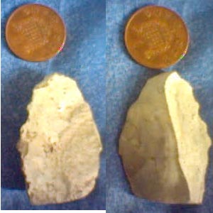
Stone tool I found on Winter Hill in a dry stream bed somewhere about SD650135 (give or take 1/2 a mile) – This is the most comfotable way of holding it. Some kind of scraper or hide cutter perhaps?

Swastika Stone is Actually a Carving of a Boomerang

news.bbc.co.uk/1/hi/england/west_yorkshire/3699593.stm

A top children’s writer is suggesting that the boomerang was invented in West Yorkshire rather than Australia.

Terry Deary, author of the Horrible Histories series, got the idea while out jogging on Ilkley Moor and spotted the famous Swastika Stone. The four-armed Bronze Age image is thought by most experts to have been used in the worship of sun or fire. But Mr Deary said: “It’s the earliest representation of a boomerang. There’s nothing else it could be.”

The writer says the first boomerangs would have had four arms as it was easier to get them to return. But over time, the two-armed boomerang was developed. Mr Deary also sees his claim as something of an act of revenge.
“Australians have sent us Rolf Harris and Kylie Minogue. It’s payback time,” he said.

Miscellaneous

West Rudham Longbarrow
Barrow / Cairn Cemetery

All righty, Magic.gov.uk gives us the scores on the doors.
The ‘oval longbarrow’ is only half visible, the other half being under the road. It was measured at 46m x 27.5m in 1938 and oriented North-South. The other longbarrow measures 66mx21m, is oriented NNE-SSW and was placed on top of an oblong enclosure.
These two longbarrows are 2 out of only 5 visible LBs in Norfolk and hence fairly important.

They part of an extended cemetary nearby with a whopper at TF815249 on private land, 4 barrows clustered about TF833255 and Harpley barrow cemetary not too far away.

One more little titbit, these lie very near the Peddars Way, gateway to wessex...

Miscellaneous

Roughton Causewayed Enclosure
Enclosure

This is sadly just a cropmark picked up by the Norfolk National Mapping Programme. A palisade ditch can also just be seen together with the possible remains of two longbarrows or mortuary enclosures flanking the enclosure.

Stonehenge replica being built in... New Zealand

wired.com/news/culture/0,1284,63227,00.html/wn_ascii

“The whole idea of the henge is that people can come out here and learn real basic astronomy, the real foundations of what astronomy is all about,” says Richard Hall, the infectiously enthusiastic and indefatigable project manager and president of the Phoenix Astronomical Society, which is building the Kiwi henge.

The aim of the project, funded by a grant of NZ$56,500 from the Royal Society of New Zealand, is to generate interest in science among people who might not normally be keen on the subject.

“We came up with the idea of Stonehenge because it doesn’t matter who you are -- everyone looks at the Pyramids and Stonehenge and structures like that (and asks) who built them, why did they build them?” says Hall.

A henge is a roughly circular flat area surrounded by a ditch and a bank of earth, sometimes with a ring of stones or wooden posts within the circular ditch. The New Zealand Stonehenge, due to open June 5, won’t merely replicate what is in the Northern Hemisphere; the aim is to create an astronomical calendar for the southern skies.

“The original Stonehenge was very accurate,” says Hall, “because, remember, they built that over a thousand-year period. You can see where they’ve actually had to move things, where things worked OK for a while and then they came out of adjustment. We’ve got a one-shot here. We’re going to get it right.”

One of the first jobs when the project started in earnest last September was to accurately survey the site, explains Kay Leather, the project’s construction team manager.

“You have to work out, as (the stars) come up, where they will actually appear, as against where a computer says they’ll appear, because they are not on the sea horizon,” says Leather. “The lintel is actually governed by the hill line so that you’ve got the stars and things happening at the right point and the rest of the henge happening at the right point.”

After the team finished surveying, it took months to fence, excavate and level the site. Late February’s torrential rains in Wairarapa, in the southern half of the North Island of New Zealand, didn’t help. The ditch kept collapsing. “I guess we dug heavy, sloppy, hard clay about three times, my daughter and I,” says Leather, laughing now at the memory of the bad weather. “There were ducks swimming around over there.”

Next they erected the pillars and lintels, hollow structures constructed using wood and cement board (hewn stone would have been too expensive and time-consuming to erect). But in a nod to the old, the finished henge will be coated with cement and covered in plaster sculpted to look like stone. Inside the “stones” will be some modern accoutrements: wires to allow a sound system to be installed. “We’ve already got two couples who want to get married out here,” says Hall.

An obelisk inside the stone circle will mark the passage of the year as the shadow of the obelisk moves in a figure eight on a mosaic of 18,500 tiles below. The tiles will display the date and the constellations of the zodiac. Outside the circle, three pairs of standing stones will show where the sun will rise and set for each of the solstices and equinoxes. “So you can see the enormous distances the sun actually travels along the horizon,” says Hall.

Every key point will have a plaque denoting its significance. “It may be a simple phrase like ‘midsummer solstice sunrise.’ The ones that are more seasonally oriented will have something like ‘time to harvest the kumara (sweet potato),’” says Leather.

To make the henge truly of Aotearoa (the Mâori name for New Zealand), the astronomers have ensured that their creation links to the stars that Polynesian navigators used to cross the Pacific Ocean. “We’ve also turned this henge into a huge Polynesian star compass so people will see how people used the stars to navigate by,” says Hall.

For those who want to learn even more, the Wairarapa site is home to the Phoenix Astronomical Society’s recreational telescope and will eventually house a research observatory as well. But even if visitors only meander amid the Kiwi henge, the hope is that they will learn something new.

Says Hall: “We’ve got the ancient here, where our ancestors started from, which is just as valid as it was 10,000 years ago, and then we are going to have the modern astronomy here as well.”