

Close-up view of the exterior entrance portal at Caisteal na Coille.


The broch entrance viewed from the interior.
Note the complete absence of a rampart at the cliff edge (right side of photo).

The rear wall in the interior of Caisteal na Coille broch.

Wall recesses close to the entranceway at Caisteal na Coille.

Recesses in the rear wall of Caisteal na Coille broch.

The guard cell adjacent to the entrance passage.


Evidence of a hollow-wall gallery at Caisteal na Coille.

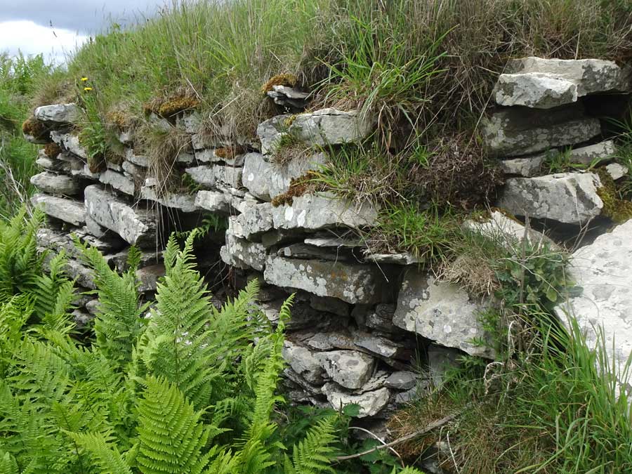
A broad grassy rampart on the northeast of Caisteal na Coille.
Visited: June 18, 2019
The Caithness village of Keiss can boast three brochs in its vicinity: Keiss South (K), Whitegate (W) and Kirk Tofts (T).
Whitegate is a probable solid-based broch, located on the shore northeast of the village of Keiss and about 175 metres farther on than Keiss South broch (marker ‘W’ on the map below). It is totally ruinous and was overgrown with long grass at the time of my visit.
All that there is to be seen are a few stretches of walling courses, an entrance passage and a chamber set back in the walling opposite the entrance passage.
There is a considerable amount of additional information on the Canmore website, particularly with respect to recent excavations at the site.
Visited: June 18, 2019
Nybster broch stands on a cliff-girt headland, protected on three sides by vertical sandstone cliffs and by a ditch that cuts off the promontory on its landward side.
The site is signposted just south of the village of Nybster, and there is a car park from which a good footpath heads south for 450 metres to the broch site. As you approach the broch, the first thing you will see is Mervyn’s Tower, a monument built of rough stones by local farmer John Nicholson to commemorate the work of Sir Francis Tress Barry who excavated the site in 1895-6.
Canmore states that Nybster is: ‘a site of major signifcance in the study of the development of the broch in that it comprises the ground-galleried block-house of a pre-broch promontory fort, a solid-based broch, and a post-broch settlement. The block-house, which displays broch-like features, including a passage checked for two doors, is probably to be dated not much before the first century BC if not within it‘.
Without doubt, Nybster is a complex side, and readers wishing to learn more about it can find copious details of the various structures and finds on the Canmore website.

First view on approaching Kirk Tofts broch. The entrance passage is concealed by rampant fern growth both in front of it and along its length. The dip in the grassy ramparts indicates its location.

This is the entrance passage to Kirk Tofts broch, viewed from outside the structure, and choked by vegetation.

Viewed from within Kirk Tofts broch, this is the entrance passage, heavily choked with vegetation.

Internal walling courses on the southwest arc of Kirk Tofts broch, with the village of Keiss beyond.
This is a close-up photograph of the walling courses within the entrance passage at Kirk Tofts broch.

This is a panorama overlooking Kirk Tofts broch, looking towards the adjacent cemetery.

This is a stitched panorama taken from the rampart of Kirk Tofts broch, looking towards the village of Keiss.
Visited: June 18, 2019
The Caithness village of Keiss can boast three brochs in its vicinity: Keiss South (K), Whitegate (W) and Kirk Tofts (T).
Kirk Tofts broch is situated immediately behind Keiss cemetery, on the A99 immediately north of the village (marker ‘T’ on the map below). There is ample parking for the visitor in front of the graveyard.
My first impression of the area was of a field thick with ferns, nettles and rampant vegetation, and I could make little progress through it. Returning to my car, I recalled that my hillwalking gear was in the boot, and fitted out with sturdy boots and gaiters, and a walking pole for balance, I returned to the broch.
My initial view was hardly inspiring. After negotiating the field of nettles, I saw ahead a section of drystone walling which I initially took to be a mere remnant of a destroyed broch. But I pressed on, and on reaching this wall, realised that it was an exposed section of the outer wall of the broch, with a well defined entrance passage. Even though this wall must have been close to two metres tall, I did not realise that there was an entrance passage through it until I was right beside it as it was completely concealed by rank vegetation both in front of and within it!
Once through the entranceway, most of the interior is defined by walling many courses high, and generally close to two metres tall. Unfortunately, thick vegetation, mainly rampant ferns growing everywhere, undoubtedly conceals many of the finer points of construction. According to Canmore there is much to see at Kirk Tofts, including two intra mural stairways, but these were not evident to me. Doubtless a visit in early spring, before plant growth has commenced, would prove more rewarding.
When visiting the site, great care should be taken as the terrain is everywhere very uneven beneath the all-concealing vegetation. A walking pole is a valuable asset in maintaining balance.
For those interested, the Canmore website provides a wealth of information relating to the structure of Kirk Tofts broch, the finds discovered within it and the various phases of its occupation, describing it as: ‘one of the best examples of a 1st phase broch (1st centuries BC and AD), re-used during the Broch II phase (2nd, 3rd centuries AD) and again during the post-broch era‘.
Visited: June 18, 2019
The Caithness village of Keiss can boast three brochs in its vicinity: Keiss South (K), Whitegate (W) and Kirk Tofts (T).
Keiss South broch, also known as Keiss Harbour broch, is just a 250 metre walk from Keiss harbour back to the hairpin bend on the access road where a signpost indicates ‘Keith Shore’. From here, just follow this path for a short distance over the grass to the obvious fenced-off enclosure (marker ‘K’ on the map below). To enter the area, follow the fence anticlockwise and you will find a gate adjacent to the field boundary north of the broch.
There is a great deal of information about Keiss broch on the Canmore website, including the fact that, as recently as 1910, the internal broch wall survived to a height of about five feet. This hardly seems the case now, the broch having endured severe robbing over the years, and little masonry remains on view.
The entire area is hummocky and was largely obscured by long grass at the time of my visit. Although nothing remains of the entrance passage, its location would seem to be signalled by a dip in the grassy ramparts that surround the broch to its east. Standing at the north of the structure, the impression is of a shallow, grassy saucer with just a small section of walling, three courses high, peeking through the obscuring vegetation. Almost certainly, walling courses do exist beneath this cover, as exemplified by the exposure of masonry in the rampart of the eastern internal wall of the broch.
Painted Pebbles
Interesting finds discovered by Sir Francis Tress Barry during his late 19th century excavations of Keiss South broch were small pebbles painted with spots and lines. Although their function is unclear, it has been suggested that they may have been used as gaming pieces or as charms. Barry exhibited these painted pebbles during a talk to the Society of Antiquaries of London on May 26, 1898. A watercolour painting of these pebbles is shown on the Canmore website.

This is a flash photograph taken looking into Clagain Souterrain from just inside the entrance portal.

This shows the steep access path to the Table.
The rock buttress on the right is the Prison and the pinnacle at centre is the Needle.
The Table lies directly behind the Needle.
The view from the roadside – Dun Chealamy atop its steep mound.

This is a stitched panorama of six photographs, across Dun Chealamy.

Just this short stretch on the periphery of the broch still reveals walling courses.


