
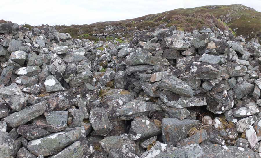
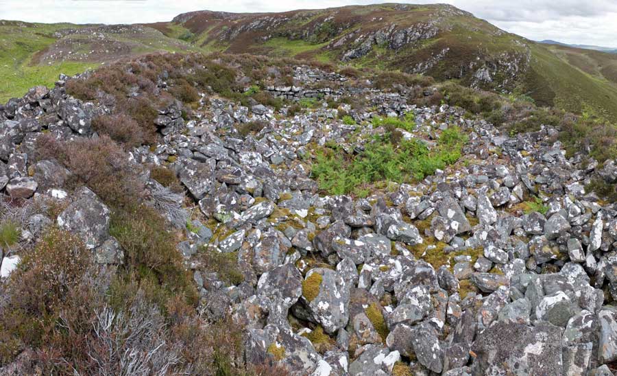
A view northwards across the summit of Dun Craig.
Image credit: Les Hamilton
A view northwards across the summit of Dun Craig.

https://hillforts.arch.ox.ac.uk/
I have spent some time examining this database, which was released into the public domain in June 2017, most particularly with respect with the area I am most familiar with: The Isle of Skye.
You would have anticipated that, following five years in its compilation, this atlas would be fully comprehensive. Despite claiming to be an atlas of hillforts, the 51 entries for Skye consist of an eclectic mix of hillforts, promontory forts and brochs. In total there are actually over 90 such sites on the island known to me, though to be fair, the Atlas does include seven entries that are not indicated on the OS maps, and which are new to me.
The actual selection of sites shows remarkable inconsistency. Along the east coast of Sleat, at the south of Skye, are the sites of at least ten known promontory forts yet the Atlas includes only four! In Waternish in the north, brochs Dun Gearymore and Dun Hallin are included yet Dun Borrafiach which lies between them is not. In Duirinish, Dun Colbost is included while the much more deserving Dun Boreraig is not. The latter is a particularly fine example of a coastal broch. These selections defy reason.
And most curious of all, just across the water on the mainland, the Atlas lists Eilan Donan Castle, apparently on a whim, because it: ”may have occupied the site of an earlier fort” (something that has not been established).
Personally, I’m mightily disappointed. Canmore is far more comprehensive and will remain my primary source of information on hillforts. It is to be hoped that other areas within the British Isles have been much more carefully compiled, and provide the user with all the information they require.
I had intended to visit this broch during June 2017 but having lost a day of my trip north to atrocious weather, had to leave this for a future visit. However, I did gain a chance view of Dun Creagach from across Loch Naver when visiting Grummore broch.
Canmore tells that this is a ‘well preserved and comparatively undisturbed’ broch which has been built on a small island, and which is connected to the shore by a causeway. Although much rubble surrounds the structure, the walling still stands over three metres tall in places and can be traced almost all round the broch.


The grassy mound of Carn Liath, with just a few foundation blocks showing.

This short section of basal walling is the only structure of note that remains at Carn Liath.

This panoramic photo shows the devastated interior of Carn Liath broch (Farr).
Visited: June 5, 2017
When motoring north along the A897 from Helmsdale to Melvich, and just over a kilometre north of The Borg, I came across the remains of Carn Liath broch nestling behind Trantlemore cemetery.
Not much to look at, this broch has been extensively robbed, and on approach is just a grassy mound with a scattering of foundation stones littered around it.
The interior has been gouged of much of its detail. It’s almost as if a road had been cut through it, but there is a stretch of basal walling to be seen to its south.
This broch is certainly not worth going out of your way for a visit but, as a quick stop on a long drive north, it offers a short excursion to stretch the legs.
Visited: June 7, 2017
Located atop a conical knoll, some 85 metres above the river Naver and about ¾ kilometre east of it, Allt an Duin is protected by steep slopes, and in summer, a jungle of bracken. This is not a target for the casual walker as the ascent is demandingly steep, though it can be eased by making for the southern ridge and completing the ascent from there. Most of the ascent was through dense bracken, until almost at the broch, when heather took over.
The broch is built from large blocks of igneous or metamorphic rock and much of its structure is concealed under a massive expanse of tumbled masonry. Hardly any structure remains in view on the exterior, although the entrance passage on the west is still discernable. Within the broch there are a few stretches of the inner wall that still reach up to eight courses high.
This must have originally been a superb fastness, not only because of its situation—defended by steep slopes—but because of the amount of rock here. If all the rocks that have cascaded down from the hilltop were replaced in the broch, it would be a mighty structure indeed.
Access to Allt an Duin is along the single-track road to Skelpick, which follows the east bank of the River Naver from the point where the A836 from Bettyhill swings to the west.
Follow the Skelpick road for almost three kilometres, passing Lochan Duinte on the way, and park in the large sand quarry on the right of the road. Immediately across the road is a farm track and the broch is prominent on its knoll about 600 metres ahead.

Allt an Duin sits atop this steep hill, at an altitude of some 85 metres.

Foundation level blocks, the first sign of the broch as I approached from the southeast.
The entrance passage still shows through the tumble of blocks on the west of Allt an Duin.

Looking west over the entrance pasageway, from within the broch.

The interior of the broch still contains several stretches of walling with several courses of blocks intact.
This panorama illustrates the extent of the broch’s interior.

This section of the outer wall of the broch is one of the few stretches showing the original courses.

Just a small sample of the massive tumble of masonry down the western flank of the broch.


Some of the large blocks that line the upper reaches of the entranceway.

Some of the foundation course walling at Dun Beag.

Looking towards Staffin Bay from Dun Beag, where the fort is guarded by steep cliffs.


Some of the copious tumble of blocks on Dun Beag’s western slopes.
Visited: May 21, 2017
The fort of Dun Beag lies just over a kilometre due south of Dun Vallerain, and likewise on a steep conical hill. Park beside the cemetery 800 metres west of Brodaig from the A855 (blue marker), walk back up to the Brodaig-Uig road, then turn left and continue for around 400 metres till a gate comes into view on your right. Dun Beag now rears steeply above you and looks impregnable, but a path from the gate heads northwards and contours all of the way round to the west of the hill then leads up easy grassy slopes to the summit (red marker). The ascent is about 100 metres.
The upper slopes of the hill are covered in tumbled stones that were once the dun’s defensive western wall. The summit is basically a level grassy plain (measuring 37 × 15 metres ) with few redeeming features other than the superb views it provides towards both the sea and the precipices of the Cuiraing. There is a well defined entrance passage bordered by large squared blocks in its upper reaches. To the east and north, the hill falls almost precipitously to the moorlands below and there is little evidence of walling. On the easier western slopes, traces of walling two courses deep can still be identified amongst the tumble. Judging from the quantity of tumbled stones on the western slopes, there must once have been a substantial defensive wall here. In a few places, on the southern and western slopes, intermittent stetches of the foundation course can still be found in situ.
For the first time, a detailed online atlas has drawn together the locations and particulars of the UK and Ireland’s hill forts and come to the conclusion that there are more than 4,000 of them, mostly dating from the iron age.
You can access this new database at
https://hillforts.arch.ox.ac.uk/
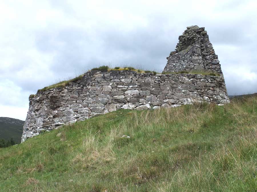

Dun Dornaigil stands above the Strathmore River amid striking scenery.
Visited: June 8, 2017
Leadoch broch stands on a low, bracken infested knoll about 150 metres west of the estate road near the south of Loch Brora. The site is very dilapilated showing no internal structure at all, and with the outer wall little more than a mass of tumble. This site is hardly worth the effort of a visit unless you are already intending to make you way to the splendid Carrol broch about a kilometre farther up the valley.
Directions are the same as for visiting Carrol broch, except that you only have to follow the path for one kilometre before tramping through bracken on your left to Leadoch (about 160 metres).
Visited: June 7, 2017
Three miles along the B873 from Altnahara, on the north bank of Loch Naver, you will come to a small parking place beside the Altnahara Caravan Club Site. This is not, perhaps, where you would expect to find a broch, but Grummore stands at the water’s edge at the north end of this site.
From outside, Grummore appears as a moss and lichen encrusted pile of stones with no structure remaining and some mature trees rising from its interior.
But the interior of the broch retains many typical elements despite being full of tumbled debris, and in places the walls rise to almost 2.5 metres tall. The entrance lies on the west of the broch, indicated from outside by a slight dip on the structure: but on the inside there is a well formed entranceway with lintels still in pace. Walking around the circumference, there are several places where there is evidence of a ground-level gallery.
There’s lots more information about Grummmore on the Canmore website.
Visited: June 8, 2017
Carrol is a relatively remote, seldom visited broch, located in a large forest clearing at an altitude of about 100 metres, about half a kilometre west of Loch Brora in Sutherland.
At first sight, the broch appears as just a huge stoneheap but there’s a real treat in store once you climb up and view the interior. The broch was excavated by the Duke of Sutherland during the 1870s, and its external walling was completely buried by the material removed from the interior, which now stands almost 4 metres tall around the entire structure. To say this is impressive is an understatement: the interior of Carrol broch is little short of overwhelming!
There is an entrance passsage on the east-southeast but this is sufficiently blocked at its inner end to deny the visitor access. Nevertheless, walking round the ramparts—effectively the broch’s second level—is quite an experience (just a pity the centre of the broch is inhabited by dense bushes these days).
Three features in particular stand out. On the west, a long staircase of at least a dozen steps, thickly encrusted by moss and lichen, but still recognisable, leads down into the wall gallery to the lower level. At the foot of the stair, is a door-frame faced with massive stone slabs which would have originally led from the gallery into the interior. Then, immediately after comes a long stretch of gallery leading all the way round to the entrance. At the time of excavation half this gallery was still roofed over but now most of it has lost its lintels and is open to the air.
How to get there
The broch stands just 50 metres north of a prominent stream (Allt Coire Aghaisgeig) which flows down into Loch Brora, and this provides the easiest way to locate it as it is not visible from below. Be advised that this visit is not quite a ‘stroll in the park’. Stout walking shoes or boots are essential, specially if you lose your way in the forest!
After following the road signposted Doll (to the south of the River Brora from the A9) for 2½ kilometres, there are a few parking spaces at the road’s end, beside the footbridge over the river (orange marker at foot of map). Backtrack about 50 metres then follow the estate road through the forest for a pleasant walk before emerging from the trees after about one kilometre. From here, continue along the road for another two kilometres to the point where it crosses the Allt Coire Aghaisgeig.
Now is the most important bit because the broch lies in woodland behind a tall deer fence. Do not cross the stream, but make directly for the fence just before the stream (150 metres over heather) where you will find a tall stile (blue marker). Once over the stile, cross the stream and head exactly south-west to Carrol broch, through woodland now consisting of fairly scattered birch trees. Another 450 metres and you’re there (red marker). Alternatively, follow the stream uphill, as it passes just 50 metres from the broch.
You may also be interested in visiting Backies Broch, similarly well preserved, just a short distance north of Golspie.
There is a lot of information about Carrol broch on the Canmore website.


