
Looking into the peninsula with the remains of the separating wall in the middle ground.
Image credit: Les Hamilton
Looking into the peninsula with the remains of the separating wall in the middle ground.

Remains of the wall from the southwest, showing the entrance passage at lower right.

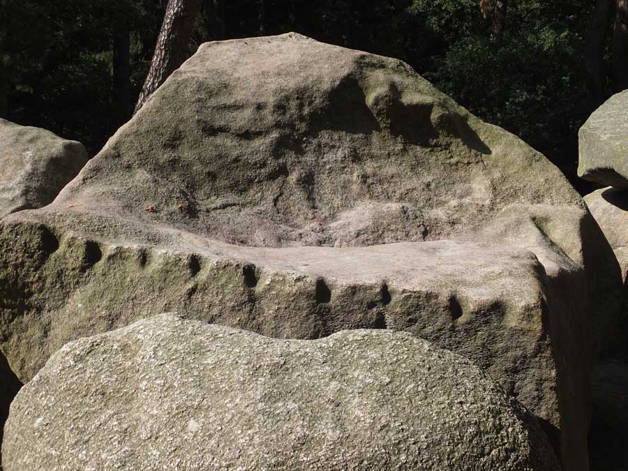
The remains of the two-metre thick wall isolating the promontory from the mainland. Both inner and outer wall faces are still well defined.

Looking along the length of the wall from the northeast.

Large foundation level blocks on the outer face of the wall.

Rigg Promontory Fort, guarded by vertical cliffs to its south.
Visited: September 5, 2017
Situated on the 120 metre summit of Ben Chrachaig, immediately north of Portree Bay, little structure remains of the tumbledown fort of Dun Torvaig.
The slopes of the hillside are a jungle of alternate woodland and thick bracken but easy access can be achieved by first following the coastal path from the Coolin Hills Hotel for several hundred metres, as far as the Viewpoint. Take the path up to the grassy Viewpoint, and you will find that it continues into the trees beyond, wending its way, in part via steps, through the trees and bracken, on to the summit plateau. The plateau is undulating, but the site of Dun Torvaig is a compact rocky knoll near its centre, guarded on the east by low cliffs.
There is a short stretch of walling still extant, two courses high, on the dun’s western side, and a rather dilapidated entrance corridor to its south. Otherwise Dun Torvaig is little more than a mass of tumbled stone. Nonetheless, the views from this eyrie are superb, particularly towards the Storr, just nine kilometres to its north.

The rocky knoll on which stands Dun Torvaig, viewed from the east.

The remains of Dun Torvaig, viewed from the rise to its southwest.

This stitched panorama highlights the degraded tumble of stonework on the southern flank of Dun Torvaig.

This last remnant of recognisable walling courses is located just north of the entrance passage.

The entranceway to Dun Torvaig, on the western side of the fort.

A few stones neatly aligned perpendicular with the direction of the wall might hint at the existence of a basal gallery.

Guide photo for finding the path to Hunebed D43 Schimmeres. Opposite the end of ‘Dopsheide’ at its junction with ‘Noordeinde’, follow the path shown for a few paces then take the dirt track to the right.

Hunebed D43 Schimmeres, covered in rank grasses in mid summer.

Impressive orthostats at the north end of the langgraaf.


Visited: July 17, 2017
Revisiting this passage grave after a lapse of several years, I was fortunate to be able to view the stones in bright sunlight, though still to some extent shadowed by trees. But what struck me most was the redevelopment on Noordeinde nearby D43.
The ‘Hunebed / Langgraaf’ sign and the dirt road leading to the hunebed were no longer obvious as the property by the roadside had turned into a mini-estate, with expansive lawns and a surrounding hedge of trees and bushes.
I made my way to the junction of Noordeinde with Dopheide as previously, faced across the road, and was confronted with the view shown in the ‘Maps / Plans / Diagrams’ section. You have to walk a few paces up the paved entranceway until you at last see the dirt track that wends to your right, round the northern boundary of this property to the patch of woodland sheltering Hunebed D43 Schimmeres.

D45 Emmerdennen, sparkling in the afternoon sunshine, in July 2017.
Evidence of boreholes, driven into stones in mediaeval times to split capstones for removal and use as masonry. Fortunately, most of the stones in D45 were too big to handle.

The repaired capstone: after a few years of weathering, the join is barely visible. A great repair job.

This ground-level composite photograph of hunebed D50 was taken from the east.

This ground-level composite photograph, taken from the west, really emphasises the grandeur of Hunebed D50.
Visited: July 17, 2017
On this, my third visit to the superb Hunebed D50 at Noord Sleen, I was at last blessed with warm summer weather and was able to enjoy the stones in glorious sunshine (last year heavy rain and gales forced me to retreat).
This excursion was pursued in a manner designed to allow several hours of pleasant woodland walking, and is one which I thoroughly recommend. I took the No 21 bus from Assen and alighted at the Voshaar bus halt, beside Recreation Center Rijmaaran (just south of the village of Schoonoord).
The walk started by entering the grounds of the Center and following the Hunebed sign directing visitors into the woodland and on to Hunebed D49 (the so-called Papeloze Kerk – blue marker). After inspecting the hunebed, I continued in the same direction for about 110 metres to a forestry road and headed south to Galgenberg, a large Bronze-Age burial mound (red marker).
From here, the walk continued through airy woodlands until the N381 highway was reached. Here a path leads left to a stile at the point where the woodland gives way to fields.
Cross the highway and straddle (or duck under) the single strand fence on the far side to gain the metalled road (Hunebedweg) leading to Hunebed D50, 400 metres farther on (green marker).
The total distance walked was just under 5 kilometres.
___________________________________
To complete my day, I continued south to the end of Hunebedweg and turned left along Zweelooerstraat into the village of Noord Sleen to catch the No 21 bus to Emmen, where I spent a further hour visiting Hunebed D43 Schimmeres (the langgraaf) and Hunebed D45 Emmerdennen.
New Pictish remains have been discovered at a fort thought to have been largely destroyed by a 19th-century development.
Archaeologists from the University of Aberdeen uncovered a longhouse and an 1,100-year-old anglo Saxon coin in a dig at Burghead Fort near Lossiemouth, Moray.
Experts believe the fort was a significant seat of power within the Pictish Kingdom, dating between 500 CE and 1000 CE.
Read the STV News Report.

Some, but not all, of the grave mounds at Kampsheide are flagged by these small information boards.

Certainly the most impressive burial mound I encountered, this one stands beside the path through the relatively open heathland to the southwest of the lake (red marker).

This smallish mound sits immediately adjacent to the path at the southernmost shore of the lake (green marker).

This is the largest mound in the clearing indicated by the blue marker.

Grave mounds in the clearing indicated by the blue marker on the maps.

Map of Kampsheide, indicating the main paths (white dotted lines).
Visited: July 17, 2017
Less than a half kilometre north of Tumulibos lies Kampsheide, a beautiful, compact region surrounding a large kettle-hole lake. The area is a mix of woodland and heath, and paths abound making it a delightful area for walking and enjoying wildlife. The map below illustrates the area and its surroundings, just west of the village of Balloo and a kilometre north of the main Assen-Rolde road. Kampsheide takes its name from the neighbouring Kamps Farm (Bourderij Kamps), and means simply Kamps heathland (not a campsite at all).
Kampsheide is but a remnant of a former much larger cemetery, and contains some fifty grave mounds of varying sizes as well as traces of Celtic Fields. The markers on the map above, shown in greater detail below, indicate the locations of some of the more prominent mounds.
Whatever your interests, this is a wonderful area to explore. I only encountered five of the grave mounds: the determined explorer will surely locate many more.
Information plaques are found by some of the mounds, stating roughly:
The grave mounds that lie in this part of Kampsheide make up part of a much larger prehistoric cemetery that stretched farther to the southwest. Already, by 1833 at the request of C J C Reuvens, the first professor of archeology in the world, a drawing had been made of the environment of this cemetery
Most likely the mounds that you see here today are grave monuments from the Iron Age, between 800 BC and the beginning of the Christian Era. During this period, it was usual to collect the remains of the cremated dead and bury them in an urn. The interment was then covered by a mound. This kind of mound is called a brandheuvel (fire hill). The simple objects that the dead took with them were usually burned (with the bodies).

Looking from the heathland, over a gate towards Galgenberg and the forest.

Galgenberg, newly strimmed, in sunshine.

This grave mound is seen from the path bordering Tumulibos.

A well proportioned mound beside the path that winds through the woodland.


This grafheuvel (grave mound), sunlit in a clearing.

A grave mound surrounded by beech trees.

Visited: July 17, 2017
More than 35 prehistoric tombs have been preserved in the Tumulibos, a small wooded area located immediately north of the Assen-Rolde road, less than two kilometres west of the village of Rolde.
Originally a much larger cemetery existed here, and as recently as 1833 over 150 grave mounds still existed. But countless graves have fallen victim to local exploitation over the years and today only these 35 or so mounds remain. The graves in this group span a period of roughly 2500 years, the oldest ones dating from around 2900 BCE. The most recent mounds—those dating since 1100 BCE—contain exclusively cremated remains, and are referred to as ‘fire hills’.
It’s thanks to the Province of Drenthe that this group of prehistoric graves has survived at all, as they had the foresight to purchase the area in 1856, thus guaranteeing its future safety. Stichting Het Drentse Landschap has administered the Tumulibos since 2001. The word tumulibos simply means a ‘wood with grave mounds’—tumulus being Latin for grave mound.
To visit the Tumulibos, take either the No 21 or No 24 bus from Assen and alight at the stop: ‘Weg naar Balloo’. Immediately north, across the main road, is Tumuliboslaan, the lane that borders Tumulibos on its east. The entire woodland is very compact, measuring only 240 × 280 metres.
As you walk up Tumuliboslaan you will see several grave mounds under the trees just a few metres into the woodland on your left. Just short of the northern boundary of the woodland, a footpath leads left and meanders between the tall beech trees, taking you past numerous impressive graves, most carpeted with fallen beech leaves. You just cannot miss them.
Visited: July 17. 2017
Just a couple of kilometres west of the village of Rolde in Drenthe, in a secluded field, stands a striking Iron Age tomb called the Offerberg. This name means ‘Hill of Sacrifices’ on account of the ancient cremation remains found there.
The site stands immediately west of Tumulibos, beneath the canopy of a large tree in the middle of a large field of grazing cattle, but cannot be approached directly on account of a perimeter electric fence.


The Offerberg cairn can be seen in the shade of large trees. This is the view from the Tumulibos, to its east.
Visited: May 25, 2017
This small ruined dun stands on a grassy knoll about 30 metres above the coast, to the southeast of Dun Maraig, on the South Cuidrach estate. There is little of note to record, except that Dun Craig occupies a fine vantage point towards the coast.
Dun Craig is hardly worth visiting on its own, but makes a fine walk when combined with other local antiquities (Dun Maraig, Dun Borve, Dun View and the Cuidrach Stone Setting).
A good path, with a stout fence to its east lies between the coast and Dun Craig, but there are stiles both before and after the dun to help you through.


Faint evidence of residual walling courses at Dun Craig.