

Heading over gentle grassy slopes to Dun Santavaig.

Dun Santavaig, viewed from the east, showing the extent of the defensive wall.

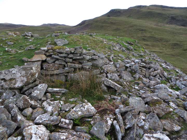
A close-up view of a section of the defensive wall at Dun Santavaig.

A short section of wall still showing traces of three courses of the original structure.


Wall footings along the western cliff-top.

A view over the northern cliffs of Dun Santavaig, towards Loch Snizort.

The cliffs at the north of Dun Santavaig, viewed from the shore.

The grassy summit of the mound containing the possible River Sligachan stone circle.

The tallest stone, encrusted with dark lichen.

The two northern stones photographed from the position of the south stone.

The two northern stones, viewed from the northwest.

The heavily encrusted south stone, deeply buried in undergrowth.

The broch of Dun Borve, viewed from the main road.

The mound of Dun Borve as seen from the coast.

This panoramic image shows the grassy saucer-like depression on the summit of Broch Borve, Greshornis.

Some of the few remaining areas showing defensive stonework.

The crags of Dun Borve, Cuidrach rise impressively from the roadside.

A jumble of stones leads up to the ruined entrance to Dun Borve, Cuidrach, on its eastern flank.

The large grassy summit of Dun Borve, Cuidrach.

The tidal island on which stood the fort of Dun Maraig, photographed from Dun Borve.


This panorama shows Dun Kearstack, with Blaven and its satellites beyond.

A view along the extensive grassy oval summit of Dun Kearstack.
Fragmentary remains indicate the thickness of the original walls of this fort.


This is a stitched panorama looking across Dun Gearymore towards the west.


The mound supporting the remnants of Dun Gleann Udalain, viewed from the northeast.

The grassy ramp that affords access to the dun.

The heather and grass clad summit of Dun Gleann Udalain: Loch Duich in the background.

Some of the dun’s outer walling, deeply embedded in rank heather and mosses.

The grassy hollow that is all that remains of Dun Kingsburgh (north).

Some fragmented walling at Dun Kingsburgh (north).


The rocky knoll where stands Dun Kingsburgh (south).

The grassy bowl defined by the foundation course at Dun Kingsburgh (south).


A telephoto photograph of Dun Hallin from the main road approaching Hallistra from the north.


Dun Hallin. A section of an additional defensive wall outside the broch can be seen at far right.


Panorama over Dun Hallin, clearly showing the location of the guard cell.


This panoramic composite image shows all seven remaining stones of Loudon Wood Stone Circle in their woodland clearing.