


The entrance to one of the finest preserved megalithic tomb in Schleswig-Holstein
Visited September 2020

Denghoog Passage grave from behind, who would suspect based on this perspective that one of the best preserved and most beautiful passage graves in northern Germany lies under this mound
Visited September 2020


Impessive capstones inside the chamber
Visited September 2020


sketch of the excavation by Dr. F. Wibel, 1868; Der Gangbau des Denghoog bei Wenningstedt auf Sylt
Visited September 2020


Atlas der Megalithgräber Deutschlands,
Teil 1: Schleswig-Holstein (1965/66)
Taidishoog, is located just about 400m southwest of the must more impressice Klöwenhoog. Not much can be seen of the burial mound, as it has been eroded over the millennia and can only be recognized as a very flat elevation.
To get to the round barrow, drive from Keitum to Archsum. After you cross the railway line, turn right after about 250 m. Follow this road, after 450 m the roads turns to the left and crosses a small drainage channel. About 150 m after the bridge, there is a small dirt road on the right. The round barrow is located on the left at the end of this dirt road.
Visited September 2020
Klöwenhoog, an impressive barrow, is located in the southwest of Keitum near a track or cycle path, only 120 m south of the railway line from Westerland to the mainland.
To get to the round barrow, drive from Keitum to Archsum. After you cross the railway line, turn right after about 250 m. Follow this road for another 450 m and park just when the roads turns to the left (southwest). Here a track branches off to the right, follow this track for 175 m by foot and you’ll reach the site.
Visited September 2020
taken from the on-site hünen.kulTOUR information board at Klöwenhoog:
Klöwenhoog & Taidishoog
The mighty, probably Bronze Age, Klöwenhoog lies on the edge of the Geest with a wide view of the marshland. A grave was found in the hill in 1870. » According to legend, the old Sylt sea hero Klow is said to rest in Klöwenhoog. With Klow, his golden ship is said to be buried here. These golden treasures are guarded by the dwarves. The golden anchors are said to be nearby in the Klaas Manis Hoog. According to a variant of the legend, the golden anchor chain even extends to the Ööwenhoog. « Klöwenhoog and Ööwenhoog are also said to be old witches’ dance areas. About 400 m southwest of the Klöwenhoog lies the flat Taidishoog in the middle of the march on a small geest knoll.


taken from the on-site hünen.kulTOUR information board:
Klöwenhoog & Taidishoog
The mighty, probably Bronze Age, Klöwenhoog lies on the edge of the Geest with a wide view of the marshland. A grave was found in the hill in 1870. » According to legend, the old Sylt sea hero Klow is said to rest in Klöwenhoog. With Klow, his golden ship is said to be buried here. These golden treasures are guarded by the dwarves. The golden anchors are said to be nearby in the Klaas Manis Hoog. According to a variant of the legend, the golden anchor chain even extends to the Ööwenhoog. « Klöwenhoog and Ööwenhoog are also said to be old witches’ dance areas. About 400 m southwest of the Klöwenhoog lies the flat Taidishoog in the middle of the march on a small geest knoll.


taken from the on-site hünen.kulTOUR information boards:
Tjülsekerhoog
The Tjülseker hill is the smallest of the four Sylt Geest cores and rises as a flat knoll over the surrounding marshland. In the middle of the hill lies the Tjülsekerhoog, hidden under a thick layer of humus soil. It contains a destroyed megalithic tomb from the Middle Neolithic.
Later, there was a settlement on Tjülseker that was used for a long time, probably as early as the Roman Iron Age. Findings such as shards, millstones or stone setting indicate this. The settlers increased the elevation by up to 1 m by applying humus. The picture shows the excavation in 1948, with the Nössedeich in the background.
Neolithic period
The neolithic period, the New Stone Age, began on the North Frisian Islands around 4,000 BC and lasted until around 1,800 BC. The permanent settlement of the North Frisian Islands probably began around 3,400 BC. The revolutionary event at the transition to the Neolithic is the change from wandering hunters and gatherers to settled farmers.
The most important material was the flint stone, which was worked with the highest level of skill. This oldest farming culture in the north is called the Funnel Beaker Culture, after a type of clay pot it uses. This culture also built the most impressive evidence of prehistory, the large stone or megalithic tombs.
Settlement in the Neolithic
During the neolithic period, Sylt was partially densely populated on the Geest, presumably divided into individual settlement chambers. The most important area is likely to have been the Kampen-Wenningstedt area, which was probably populated throughout. Since the sea level was then about 3 m lower than it is today, the geest areas populated at that time were significantly higher than today.

Sylter Archiv
taken form on-site display board


Kolkingehoog (aka Archsum 4) is a heavily destroyed passage grave. The stones of the grave become visible at low tide, it lies in the tidal flats and is therefore exposed to destruction by the North Sea. The position of the stones has changed a lot due to the constant interference of the sea, and so the original burial chamber can no longer be recognized.
To get to the tomb, turn shortly before leaving the village in the direction of Keitum from the Dorfstrasse in Archsum south into Uaster Reeg. Then turn right into Weesterstich and after 250 m turn left into Deichweg. Follow this road south-west for 1.6 km, there is a parking lot immediately in front of the Nössedeich (Deich means dike). Walk directly over the dike at the parking lot towards the tomb, which lies about 170 m south of the parking lot. A visit at low tide is recommended.
Visited September 2020

Not much left of Archsum 4, to be honest
Visited September 2020


Large boulder near Archsum 4, looks like a capstone of a destroyed tomb.
Visited September 2020
Directly on the other side of the dike from the megalithic tomb Merelmerskhoog (aka Archsum 1) are the two giant beds Archsum 2 and Archsum 3 directly on the coast in the Wadden Sea. Both graves are badly affected by their location, as they have been exposed to ebb and flow every day for thousands of years. Of the two graves Archsum 3 is better preserved and its structure can be seen more clearly.
Archsum 2 is an extended dolmen in a giant bed. It lies only 20 m southeast of Archsum 3. According to Wikipedia the tomb was examined by Gottfried Schäfer in 1963. The position of the stones has changed due to the constant interference of the sea, so the original burial chamber can no longer be seen. The chamber is an extended dolmen with the internal dimensions of 2.3 × 1.2 m. It consisted of three pairs of supporting stones. A large, flat boulder was leaning against the narrow western side. The end of the east side was formed by an entry stone embedded in the ground.
To get to the tomb, turn shortly before leaving the village in the direction of Keitum from the Dorfstrasse in Archsum south into Uaster Reeg. Then turn right into Weesterstich and after 250 m turn left into Deichweg. Follow this road south-west for 1.6 km, there is a parking lot immediately in front of the Nössedeich (Deich means dike). Follow the directions to the tomb Merelmerskhoog (aka Archsum 1) and cross the dike at the tomb or walk directly over the dike at the parking lot towards Kolkingehoog (aka Archsum 4) and follow the coastal path in a north-west direction for about 900 m. Archsum 2 and Archsum 3 are then only a few meters from the coast in the sea. A visit at low tide is recommended.
Visited September 2020


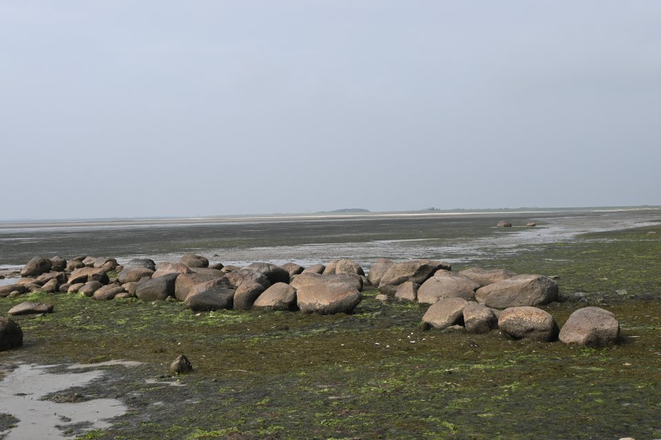
Archsum 2 in the foreground, Archsum 3 behind and two big boulders to the right
Visited September 2020

Directly on the other side of the dike from the megalithic tomb Merelmerskhoog (aka Archsum 1) are the two giant beds Archsum 2 and Archsum 3 directly on the coast in the Wadden Sea. Both graves are badly affected by their location, as they have been exposed to ebb and flow every day for thousands of years. Of the two graves Archsum 3 is better preserved and its structure can be seen more clearly.
Archsum 3 is an extended dolmen in a giant bed. It lies only 20 m northwest of Archsum 2. According to Wikipedia the tomb was examined by Gottfried Schäfer in 1963. He found two chambers in the five to six meter wide giant bed. The western chamber was formed by three supporting stones on the southern long side and two on the northern long side. On the eastern and western narrow sides, there was a relatively flat erratic boulder. A floor covering made of stone tiles was only preserved in a few places. The eastern chamber is formed by two supporting stones on the southern long side and one on the northern long side. A boulder was set up on the eastern and western narrow sides.
To get to the tomb, turn shortly before leaving the village in the direction of Keitum from the Dorfstrasse in Archsum south into Uaster Reeg. Then turn right into Weesterstich and after 250 m turn left into Deichweg. Follow this road south-west for 1.6 km, there is a parking lot immediately in front of the Nössedeich (Deich means dike). Follow the directions to the tomb Merelmerskhoog (aka Archsum 1) and cross the dike at the tomb or walk directly over the dike at the parking lot towards Kolkingehoog (aka Archsum 4) and follow the coastal path in a north-west direction for about 900 m. Archsum 3 and Archsum 2 are then only a few meters from the coast in the sea. A visit at low tide is recommended.
Visited September 2020
taken from the hünen.kulTOUR information board (located at Archsum 1):
Riesenbetten 74 & 75 (Riesenbetten = Giant beds)
The megalithic tombs from the Neolithic (New Stone Age) lying in the mud flats in front of the dike bear witness to the change in the landscape over the past millennia. They were erected on the geest, which was then still unaffected by the sea. The sea level at that time was about 3 m lower than it is today. In the meantime, the stone tombs were and continue to be destroyed by ice and storm surges.
The right picture shows the stone chamber of the “Riesenbett 75” lying north in 1963, from which even the hill was partially preserved until 1922. An urn was found there. The left picture shows the stone chamber of the “Riesenbett 74”.
Don’t know if these two boulders in the background also belong to Archsum 3 or another tomb.
Visited September 2020