


Archsum 3 in the foreground with Archsum 2 in the background
Visited September 2020

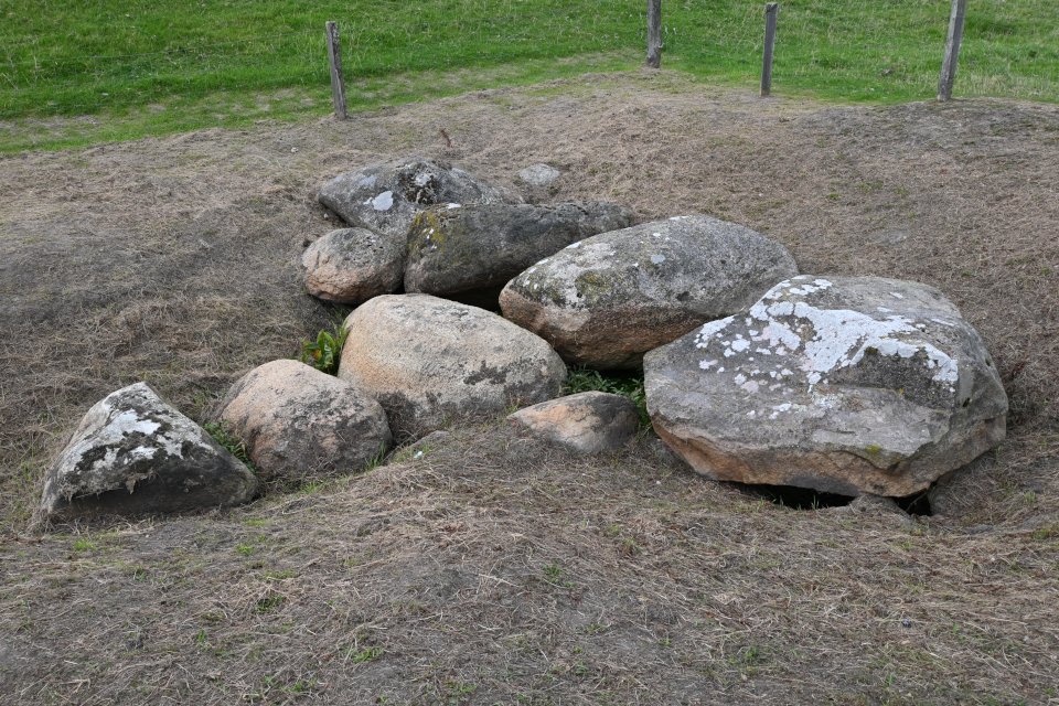
The eastern burial chamber
Visited September 2020

The eastern burial chamber
Visited September 2020

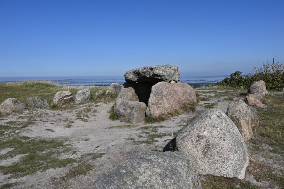
The western burial chamber
Visited September 2020


Atlas der Megalithgräber Deutschlands,
Teil 1: Schleswig-Holstein (1965/66)
The Merelmerskhoog is one of the best preserved megalithic tombs on Sylt. The passage grave is located southwest of Archsum directly at the foot of the Nössedeich (Deich means dike). The two giant beds Archsum 2 and Archsum 3 are in a direct line on the other side of the dike in the Wadden Sea. The locals call this place in Sylt Frisian “Mootjis Küül” (Grandmother’s Hollow).
The burial chamber is oriented in a north-south direction and consists of four support stones on the long sides and two stones on the narrow sides. There are four capstones on top of the chamber, the middle ones are slightly displaced. The size of the chamber is 5.3 × 1.5 m. The 3.5 m long corridor begins in the middle of the eastern long side and consists of three pairs of stones with corresponding cap stones. Probably because the tomb is at sea level (possibly even a little lower), there is water in the burial chamber.
To get to the tomb, turn shortly before leaving the village in the direction of Keitum from the Dorfstrasse in Archsum south into Uaster Reeg. Then turn right into Weesterstich and after 250 m turn left into Deichweg. Follow this road south-west for 1.6 km, there is a parking lot immediately in front of the Nössedeich (dike). Walk left from here in a northwesterly direction for about 800 m on the paved road (don’t cross the dike) to reach the site.
Visited September 2020
taken from the on-site hünen.kulTOUR information boards:
Merelmershoog
The Merelmershoog lies on the edge of a small Geest ridge, the Mittelmarsch (Merelmers). The Neolithic megalithic tomb is an oval passage grave of the Nordic type. It is one of only three surviving passage graves on Sylt, including the famous Denghoog in Wenningstedt. The burial chamber probably consisted of 12 supporting stones (one of which is missing) and four cap stones and was about 1 m high. When the Nössedeich was built in 1938, the tomb was in danger, but the relocation of the dike made it possible to preserve it.
Other destroyed megalithic tombs, which today lie far in front of the dike in the mudflats, testify to the former expansion of the Geest. About 1,000 m southeast of the tidal flats are the remains of another passage grave, the Kolkingehoog. It was destroyed by storm surges and ice drift in the 19th century.
Megalithic tombs
In the Middle Neolithic, the Funnel Beaker Culture built imposing large stone or megalithic tombs within a short period of around 600 years. These tombs, which are still imposing today, partly consist of massive boulders. Almost 50 megalithic tombs are known of Sylt, eight of which have been wholly or partially preserved. The most imposing of them and one of the most beautiful and best-preserved megalithic tombs in Germany is the Denhoog in Wenningstedt.
Megalithic tombs are collective graves that have been used repeatedly and over a very long period of time. Only the bodies of the dead were buried. The tombs were often reused in the following epoch (Bronze Age). The shape of the tombs developed from simple rectangular stone chambers to dolmens, polygonal chambers and passage graves. The corridor made subsequent burials easier. The tombs were covered with earth and had the outer shape of round or long barrows. It is disputed whether the dead were buried directly in the graves or whether only the bones were later deposited.
To the south-west of Archsum there are a couple of megalithic tombs, some of which have been destroyed, as they are located in the Wadden Sea and are therefore exposed to ebb and flow. Archsum 1 and the two giant beds Archsum 2 and Archsum 3 are the best preserved of these.
To get to the tombs, turn shortly before leaving the village in the direction of Keitum from the Dorfstrasse in Archsum south into Uaster Reeg. Then turn right into Weesterstich and after 250 m turn left into Deichweg. Follow this road south-west for 1.6km, there is a parking lot immediately in front of the Nössedeich (dike).
Visited September 2020


Atlas der Megalithgräber Deutschlands,
Teil 1: Schleswig-Holstein (1965/66)
The Tipkenhoog is probably a Bronze Age burial mound, which is located just around 80 m northwest of the Harhoog.
The mighty hill was archaeologically examined as early as 1873. In the summer of 1940 the hill was used as an observation post for the naval flak and was quite damaged as a result. In 1944 the site was restored to its old form. Another restoration took place in April 1982.
To get to the site, turn into the road Gurtstig at the roundabout in front of the entrance to Keitum. Follow this for about 900 m, then turn left into Christian-Peter-Hansen-Allee and then take the next road to the right (Melnwai). After approx. 70 m turn right into the street Am Tipkenhoog and follow this for 250 m to a large parking lot on the left. Park your car here and walk the remaining 300 m to Tipkenhoog and Harhoog.
Visited September 2020
taken from the on-site hünen.kulTOUR information board:
Tipkenhoog
In the mighty Tipkenhoog, presumably from the Bronze Age, the tomb of the guardian of the Sylt warriors (fighting giants) in the fight against the Danes is said to lie. “Tipken, the Heidumer Hahn, had a so-called watchtower (...) at the extreme south-east of the land, the site of which is still known as the Tipkentower. The giant Tipken was killed during a fight with the Danish warriors and was buried by his tower under the Tipkenhoog.”
The Tipkentower is said to have been located immediately south of the mound. When the Tipkenhoog was excavated in 1873, only a few stone packs were found. The Tipkenhoog was badly damaged by fortifications during World War II, but restored in its old form in 1944. In 1982 it was restored.
The Keitumer Biike (bonfires) was ignited on the Tipkenhoog until the mid-1980s.


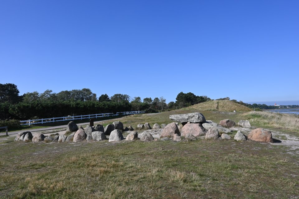
At the south-eastern end of Keitum, right on the edge of the tidal flats, lies the Harhoog, a giant bed with an extended dolmen or rectangular dolmen. The tomb was moved here in 1954 because it had to make way for the expansion of Sylt Airport.
To get to the grave, turn into the road Gurtstig at the roundabout in front of the entrance to Keitum. Follow this for about 900 m, then turn left into Christian-Peter-Hansen-Allee and then take the next road to the right (Melnwai). After approx. 70 m turn right into the street Am Tipkenhoog and follow this for 250 m to a large parking lot on the left. Park your car here and walk the remaining 300 m to Tipkenhoog and Harhoog.
Visited September 2020
taken from the on-site hünen.kulTOUR information board:
Harhoog
The Harhoog is a giant bed from the Neolithic (New Stone Age). The mound of the giant bed was originally about 32 m long. In the middle of the mound enclosed by boulders was a rectangular dolmen as a stone chamber. (Picture below)
The Harhoog was originally located on the “Weenk” hill, which was built up in prehistoric times, southwest of the Keitum Church. The mound, which was about 1.8 m high at that time, only protruded about 60 cm over the hill. Part of the mound was excavated in 1926 because of the expanding gravel pit. Nearby was another giant bed, probably of the same type, which was removed in 1937. In 1954 the Harhoog was relocated to its current location due to the expansion of the airfield.


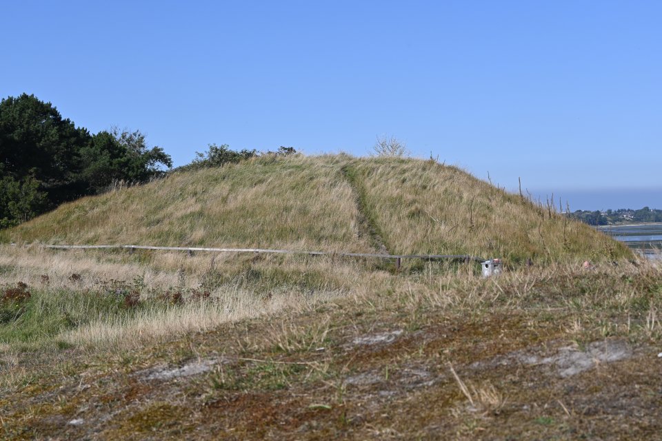
With burial mound Tipkenhoog in the right background
Visited September 2020


Atlas der Megalithgräber Deutschlands,
Teil 1: Schleswig-Holstein (1965/66)
The megalithic tomb Hademarschen is located on the western outskirts of Hanerau-Hademarschen near a sports facility. Similar to the megalithic tomb at Bunsoh, it is still surrounded by its burial mound.
The complex is an east-west oriented passage grave of the Holstein Chamber subtype with a length of 3 m and a width of 1.5 m. There are three pairs of wall stones on the long sides and one end stone each on the narrow sides, all of which are still in situ. Of the three original capstones, the western and central ones have been preserved. They are still resting on their supporting stones. The entrance to the chamber is located between the eastern and central wall stones on the south side. In front of this was originally an approximately 2 m long and almost 0.5 m wide corridor made of two pairs of wall stones. Only the two western wall stones are preserved.
To get to the tomb drive from the center of Hanerau-Hademarschen in a northwesterly direction on the Hauptstraße (L131) towards Spann. Right after you pass the school Theodor-Storm-Schule, turn left and use the car park. Walk towards the two football pitches, pass the first one to your right, you should see a tower. The tomb is within the tumulus before the tower (there is another tumulus after the tower). Access is from behind, so walk around the tumulus and use the path before the tower.
Visited June 2020


