


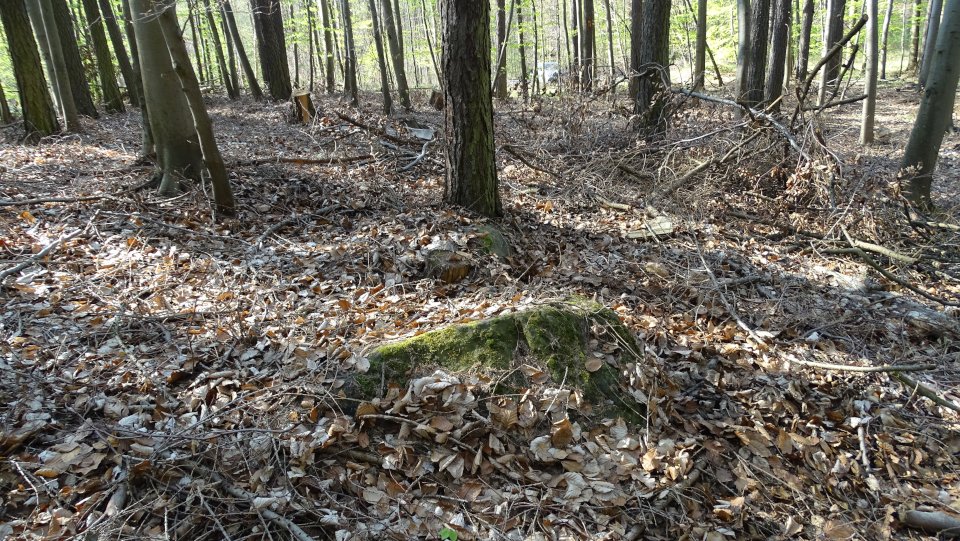
Only three capstones and the tip of a suspected support stone stick out from the forest soil. The rest of the tomb is probably still hidden in the ground. In the front capstone are two natural or possibly artificially made, circular depressions, which gave the tomb the name “Operstein” (sacrificial stone). On the back capstone are some small cups.
From Marienborn take the K1656 towards Morsleben. Immediately in front of a railroad crossing there is a parking space with information board on the left hand side. From here all Marienborns’ megalithic tombs in the forest of Bischofswald can be visited on foot.
The Opfersteine are the westernmost grave. Follow the forest trail Bierweg which turns right after the parking lot and leads in a slight arc first to the north, then in a western direction. After about 750m, a path leads to the right (the third to the right) in a northwesterly direction. During my visit in 2019, there was a corresponding signpost (see image 1). Follow this path for about 300m. In a slight right bend, a path leads to the left (southwest). After about 85m there is a small path to the left, which leads southeast. Follow this path and you’ll reach the site after 40m.
Visited April 2019
taken from the information board:
Archaeological-historical hiking trail Marienborn (8)
Opfersteine
Megalithic tomb, around 3300-2900 BC
Mid-19th century Forestry master Ernst Schmidt and local historian Gustav Maas from Altenhausen discovered these three large stone blocks lying in a row. Probably due to the two natural and connected by a channel depressions on a stone, the site was named “Opferaltar” (sacrificial altar) or “Opfersteine” (sacrificial stones). Only in 1921, the stones were recognized as capstones of a megalithic tomb.
Unlike the northern megalithic tombs, the burial chamber has been sunk into the ground so that the capstones are at surface level. Perhaps these were formerly covered by a mound and not visible. The building material used was the tuber quartzite (also known as lignite or tertiary quartzite) which occurs in the region. Three capstones and the bearing surface of a wall stone are visible.
The main distribution area of ??sunken megalithic or chamber tomb lies in the Hessian-Westphalian area (gallery graves) up to the Paris basin (Allées couvertées).
From the Middle Elbe-Saale area and the Lower Saxon region only a few sunken chamber tombs are known, which were generally much smaller (5-10 m long). Here, these megalithic tombs are associated with the Walternienburg-Bernburg culture (around 3300-2900 BC), while the non-sunken or low-set, consisting of erratic blocks, nordic megalithic tombs of the Haldensleber Forst and the Altmark region were often built much earlier (from about 3600 BC). Despite the lack of research to date, it can be assumed that the “Opfersteine” were a megalithic burial chamber for a village or relatives group.

Archaeological monuments in the Bischofswald near Marienborn
Visited April 2019

Archaeological monuments in the Bischofswald near Marienborn (map)
Visited April 2019


There are only a few stones remaining of this tomb, so no real structure is recognizable anymore.
You drive from Harbke on the K1373 to the northeast towards the Autobahn A2. About 2.5 kilometers just before a railroad crossing, there is a forest road on the right side of the road which leads southeast. There you can park the car. Follow this forest path for about 850 meters until you reach a right bend. The remains of the tomb are then about 40 meters left from the path.
Visited April 2019


The tomb is completely destroyed. It is only a heavily rumbled, up to 50 cm high mound. Due to the dense vegetation the mound is hardly recognizable on the images.
You drive from Harbke on the K1373 to the northeast towards the Autobahn A2. About 2.5 kilometers just before a railroad crossing, there is a forest road on the right side of the road which leads southeast. There you can park the car. Follow this forest path for about 850 meters until you reach a right bend. The remains of the tomb are then about 70 meters from the path, right in the thicket of the forest.
Only for real enthusiastics, a GPS device is highly recommended.
Visited April 2019


Only three scattered stones on an elongated hill are all that remains from this destroyed megalithic tomb.
You drive from Harbke on the K1373 to the northeast towards the Autobahn A2. About 1.8 kilometers after the road leads into the forest and about 650m before a railroad crossing, there is a forest road on the right side of the road. There you can park the car. Follow the forest path for about 60 meters. Right of the path is now a well-recognizable hill in which lie the sad remains of this tomb.
Visited April 2019


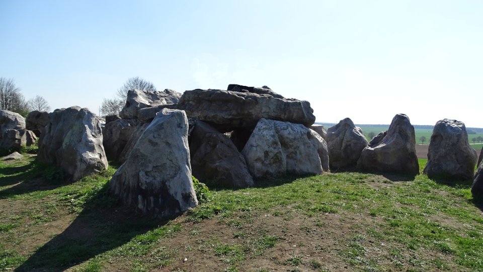
The Lübbensteinen are two passage graves whose origin dates back to around 3500 BC. Both sites are oriented in north-south direction. They are the southernmost megalithic tombs in northern Germany and were built from local lignite quartzite.
The two megalithic tombs are located west of Helmstedt on the main road 1 in the direction of Königslutter on the St. Annenberg. The tombs are a bit off on a raised plateau with a parking lot. The northern tomb was completely reconstructed, the southern tomb only incomplete, since half of the stones were missing.
Unfortunately, during my visit on Good Friday 2019, three larger groups of people celebrated on the grounds. Children clambered on the stones and adults sat on the capstones. On my pictures, I tried to depict the people as far as possible, or I removed them afterwards from the pictures as well as possible.
Visited April 2019

The southern tomb after restoraton 1936 (left)
The southern tomb after restoraton 2003 (right)
Visited April 2019

The destroyed northern tomb before excavation 1936 (left)
The northern tomb after restoraton 1936 and 2003 (right)
Visited April 2019
taken from the information board:
The Lübbensteine 4000 BC
Landmarks of archeology in the Brunswick region
The records of the two impressive prehistoric grave monuments on St. Annenberg in front of Helmstedt reach back to the 17th century (Figs.1 and 2).
The tombs themselves are much older and were built in the middle of the 4th millennium BC. It is due to the intervention of professors of the University of Helmstedt that the Lübbensteine escaped the fate of other megalithic tombs in the region, which were smashed or blown up because they disturbed the farming of the fields and the stones could be used well as building material. Today, the Lübbenstein are designated as cultural and historical monuments.
In the 19th century, the Lübbensteine were much worse preserved than the viewer suspects today. In 1935/36 both tombs were examined by the archaeologists Hofmeister and Thaerigen. More than half of the stones were missing from the southern tomb (near your location), most notably the capstones of the chamber, of which only one was left. Much better preserved was the tomb to the north (Fig. 3), which was also the model for the reconstruction of the second site. Here 40 of the originally 45 stones of the enclosure were preserved. There were also all five capstones, but two of them were broken.
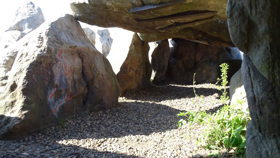
Time had caused damage on the in 1936 restored tombs (figs 4 and 5), so that in 2001 there was an acute danger of collapse. With the help of the Brunswick United Monastery and Study Fund and the city of Helmstedt, a damage assessment was carried out in 2002, which was completed in 2003 with a refurbishment and securing of the sites. In addition, the interior of the two grave chambers, originally paved with stone slabs, was laid with gravel to convey an authentic spatial impression (Figs. 4 and 6). At the southern grave, the monochromatic capstone erected hitherto in a distorted, stele-like manner has been restored to its original function over a newly added supporting stone (Figs. 5 and 6).
Both graves are megalithic or large stone tombs, built from local lignite quartzites. The actual burial chambers are formed by yokes from two supporting and one capstone each. The chambers of both tombs today consist of five such yokes, although it is not entirely certain that this was the original state of the southern grave. From the east, a corridor flanked by two vertically placed stones, which is only preserved at the northern tomb, leads into the burial chamber. Further out, a rectangular stone enclosure of vertically placed stones runs. The gaps between the individual stones of the chamber and those of the enclosure were closed with dry-stone-like small stones. The area between the chamber and the enclosure was filled with soil, so that only the capstones of the chamber and the enclosure could be seen from the outside. The grave resembled in its original appearance with it one of the typical Neolithic wooden houses.
The excavations on the Lübbensteinen have brought almost no finds. Old excavations that have been handed down since the 18th century had ravaged the entire area. Such megalithic tombs have been visited for generations as burial places, and in well-preserved tombs remains of more than a hundred skeletons were often salvaged in the chambers. The dead were equipped with vessels (probably containers for food on the way to the afterlife), jewelry and equipment and weapons made of stone.
The Lübbensteine are the southernmost megalithic tombs in northern Germany. Further comparable graves are known from Groß Steinum, Süpplingenburg and the Marienborner Forst. In Groß Steinum, the archaeological park “Baustelle Großsteingrab” (construction site megalithic tomb) provides detailed information about the construction and interpretation of the megalithic tombs. In the south following low mountain range landscapes suitable large stones were missing as building material. Here comparable grave sites were built from stone walls, from stone slabs or also from wood. The reconstruction of a wall chamber grave excavated can be visited at Remlingen on the southern edge of the Asse.


From east towards the entrance
Visited April 2019
Clamps were attached to secure the capstones
Visited April 2019