
Nucleus


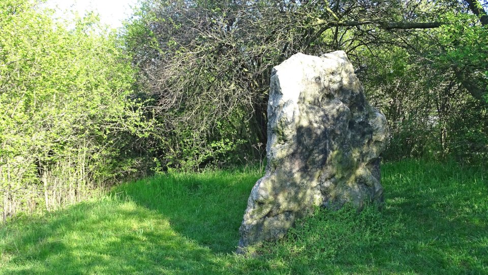
Although this stone is no longer upright and was deposited on several stones, this is a menhir and not the capstone of a megalithic tomb. The menhir was originally upright near the station and was relocated at some time.
The menhir is made of quartzite. Its height is 370 cm, the width 140 cm and the depth 58 cm. He is plate-shaped and heavily rugged. It is a pity that this great menhir stands no longer upright.
On an information board the place name Güsten is derived from the stone:
“On glaciers back it came to us
in ancient times a sacrificial stone
gave our village it’s name
Gudenesstein
970 Guddenstein, 1278 Guzsten, 1373 Güsten.”
The name “Speckseite”, as well as the menhir of the same name from Aschersleben, is derieved after the shiny, somewhat on bacon (soapstone) reminiscent surface. The menhir is located in the middle of town, directly on the B 185.
Visited April 2019


The stone is located about 4 km north of Aschersleben. There it stands tree-lined in the middle of a wind farm today. The menhir consists of brown coal quartzite. Its height is 1.84 m, width 1.88 m and depth 0.60 m. The name “Blaue Gans” (Blue Goose) may indicate that the menhir served as a place of judgment during the Middle Ages, as the term “Blaue Steine” (blue stones) is often used for court stones.
Drive in Aschersleben on the B180 northward towards Winningen. About 400 m before you cross the B6 turn right into a road between two fields Drive for about 1.2 km before you reach a T-crossing, turn left (north) here. Cross the B6 over a bridge and after 1.5 km turn right. After another 700 meters turn left. Then turn right after 300 meters and follow the path along the wind turbines. After 500 meters turn left behind the small grove. After 130 meters then a small path leads left into the grove, which leads directly to the stone.
Visited April 2019

Visited April 2019
Image credit: Uwe Häberle 04/2019

Visited April 2019
Image credit: Uwe Häberle 04/2019
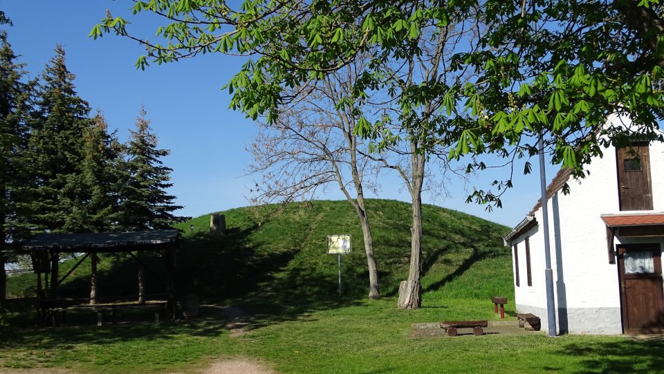
The menhir stands on a natural hill, which was further artificially piled up as a burial mound. An approximately 4,000-year-old stone cist was found, which can be placed either in the end of the Neolithic or the beginning of the Bronze Age. The menhir is to be interpreted as a funeral stele. It is a platy, about 1.90 meters high and still 1.0 meters in the ground stuck menhir of tertiary quartzite. Numerous old, hand-forged and also newer nails are hammered into the stone. Sadly, the menhir is defaced by some Graffitti.
You drive from Aschersleben in the direction of Groß Schierstedt. 100 meters behind a railway underpass is the grave mound with the menhir on the right. There is an information board (of which the information here essentially comes).
Visited April 2019
taken from the information board
Kulturkreis Adam Olearius Aschersleben e.V.:
Grave mound
Speckseite
Aschersleben
Here on the eastern outskirts of Aschersleben, stands near the road to Groß Schierstedt on a hill a 1.90 m high menhir made of quartzite (about 1.0 m are still stuck in the ground).
The vernacular has given this stone because of its shiny surface the name “Speckseite”.
It stands on a natural hill, which is still set up a flat hill. Directly near the stone a prehistoric stone cist was proven by excavations. This grave has an age of about 4000 years and belongs to the late Neolithic or early Bronze Age. It can be assumed that everything was created at the same time: stone cist grave, burial mound and grave stele the “Speckseite”.
Around the grave mound medieval graves can also be found.
The old burial mound with the Menhir was then in the Middle Ages an important court in Schwabengau.
It was not until much later, in modern times, that the tradition of driving in nails into the stone by passing blacksmiths and carters became a sign of their skill. These nails are mainly seen from the east side of the stone.
Thus, the “Speckseite” of Aschersleben has much to offer: it is grave stele of a prehistoric tomb, court stone and nail stone in one.

Visited April 2019
Image credit: Uwe Häberle 04/2019
Visited April 2019
Image credit: Uwe Häberle 04/2019

Numerous old, hand-forged and also newer nails are hammered into the stone
Visited April 2019
Image credit: Uwe Häberle 04/2019

Visited April 2019
Image credit: Uwe Häberle 04/2019

Visited April 2019
Image credit: Uwe Häberle 04/2019
The Stockhof is a burial mound of the late Neolithic Bernburg culture near Gröna, a district of Bernburg (Saale). Here, a central wall chamber grave with several burials and numerous grave goods was found. Furthermore, a burial from the Migration Period was discovered in the hill bed. The hill is located a few hundred meters behind the eastern outskirts of Gröna directly on a power line. The hill is southwest-northeast oriented and originally had probably an oval shape. At the time of the excavation he had a length of 30 m and a width of 7 m. The stone on the hill probably has nothing to do with the tomb inside, but was added later.
You drive from Gröna in the direction of Bernburg on the Grönaer Landstraße (K2105). Shortly after the last houses, the road turns left. There you drive straight ahead, 50 meters further on you will find the hill on the right, with the remains of the tomb.
Visited April 2019
taken from the information board
Arbeitskreis Archäologie im Bernburger Land e.V.:
The Stockhof
Middle Neolithic:
Bernburg culture approx. 3,100 – 2,650 BC
Late Migration Period: 6th century
The Stockhof is one of the eponymous sites of the Bernburg culture and in terms of research history extremely significant. It is a typical representative of those burial mounds from the Middle Neolithic period, which once dominated the area around Bernburg. Few of them have survived until today (Schneiderberg near Baalberge, Spitzes Hoch and Pohlsberg near Latdorf).
On the occasion of a summer excursion of the Berlin Society for Ethnology, Anthropology and Prehistory in 1884, the study of the hill was started by the Bernburg History and Antiquities Society in the presence of Rudolf Virchow, the well-known Berlin anatomist and prehistoric researcher, and completed just after a few days. The findings were not completely recovered by this inadequate examination method.
In the middle of the hill was a construction of stratified fieldstone – a wall chamber grave – with numerous human skeletal remains (collective grave). The dead were partly buried in typical squat position, partly they were disorderly mixed-up. There were no burn marks as observed in the peak high at Latdorf. As grave goods about 60 pottery, flint blades and pierced Canidenzähne (jewelry) were salvaged. Unlike other hills other burials from the Neolithic or Bronze Age were not registered. However a body grave from the Migration Period (6th century) was found on the hillside periphery.
The details of the grave construction and the ceramics found date from the hill around 3000 BC. At that time, the characteristic vase ceramic from the Stockhof, together with the corresponding finds from the Spitzen Hoch, were considered to be so important that in 1892 the Berlin prehistorian Alfred Götze spoke of the so-called “Bernburg type” for the first time. Today, the name “Bernburg Culture” is used for this archaeological group.


The Schneiderberg is a burial mound of the Neolithic and the Bronze Age in Baalberge, a district of Bernburg (Saale). During an excavation in 1901 ceramic vases of an archaeological culture were first discovered here, which later received the name Baalberger culture. So Schneiderberg became the eponymous site for this culture.
The hill has a height of 5.57 m and a circumference of 133 m. Its top is flattened and forms a plateau with a diameter of 8 m. The hill was probably originally surrounded by a ditch, but was heaped up in the 19th century.
The Schneiderberg – Baalberge is located within a allotment garden. Coming from Bernburg, follow the main road Bernburger Straße (L146) first and then leave it at the first slight right-hand bend, going straight on into the bypass. After the second house on the left side, turn left and continue straight ahead until you reach the entrance to the allotment garden. There you can park. The burial mound is then a few meters further.
Visited April 2019
taken from the information board
Arbeitskreis Archäologie im Bernburger Land e.V.:
Der Schneiderberg (Tailor Hill)
Middle and Late Neolithic:
Baalberger culture approx. 4,100 – 3,400 BC
Walternienburg-Bernburg culture approx. 3,300 – 2,700 BC
Globular Amphora culture approx. 3,100 – 2,700 BC
Corded Ware culture approx. 2,800 – 2,200 BC
Early and Late Bronze Age:
Unetice culture approx. 2,100 – 1,600 BC
Saale estuary group approx. 1,300 – 700 BC
The Schneiderberg is one of the burial mounds of the Bernburg region, which achieved special fame in archaeological research. His excavation took place in 1901 by the Bernburg History and Antiquity Society under the direction of Ferdinand Kälber and authoritative participation of Paul Höfer (1845-1914), a renowned historian and archaeologist, who later also earned lasting merits in the careful study of the Pohlsberg at Latdorf (1904). The stratigraphic observations made on both burial mounds significantly contributed to the clarification of the chronology of the Middle German Neolithic period.
The stone slab grave in the center of the hill (length: 1.5 m / width: 0.8 m / height: 1.1 m) with a mighty cover plate (about 2.3 mx 3 mx 0.3 m) was about 5.3 m below the hill plateau and contained a bodily burial and two characteristic vase additions (jug and cup, see figure). These were later named for the Baalberg culture of the Middle Neolithic. On the side of it was found as a burial a split stone slab grave with body graves of the Walternienburg-Bernburg or Globular Amphora culture. In the upper mound to the northwest of the central tomb, a body tomb of the Corded Ware culture with a cord cup, oyster pot and silex blade was uncovered. Above the central grave followed several stone boxes with burials of the early Bronze Age, partly with dagger accessories. Finally, some destroyed stone boxes in the lateral mantle of the hill are mentioned, which presumably contained urn graves from the late Bronze Age.
In the immediate eastern neighborhood of the burial mound in 1990 a multi-phase settlement site of the late Bronze Age to early Iron Age and Early Bronze Age graves were uncovered.


taken from a nearby information board, sorry for the reflections
Visited April 2019
Image credit: Uwe Häberle 04/2019

taken from a nearby information board
Visited April 2019
Image credit: Uwe Häberle 04/2019

taken from a nearby information board, sorry for the reflections
Visited April 2019
Image credit: Uwe Häberle 04/2019

taken from a nearby information board
Visited April 2019
Image credit: Uwe Häberle 04/2019


The Sieben Steine (Seven Stones) are a group of stones in Preußlitz, a district of Bernburg (Saale) in Saxony-Anhalt, which are either the remains of a group of standing stones or a megalithic tomb. The stones are now in the southeast of Preußlitz in the Cörmigker street directly in front of a residential building opposite the cemetery. Nothing is known about their original location, except that it was a field in the vicinity of Preußlitz. The term “Rügensteine” has two possible origins: Either it goes back to the naming of the group as “a row of stones” (German Riege – Reihe) or the former function as a place of jurisdiction (Rügesteine – rebuke stones or judgment stones).
As the stones are located directly on main road from Preußlitz to Cörmigk access and parking is quite easy.
Visited April 2019
taken from the information board
Arbeitskreis Archäologie im Bernburger Land e.V.:
Die Sieben Steine (The Seven Stones)
Middle Neolithic – Middle Ages approx. 3,500 BC – around 1,500 AD
Opposite the Preußlitzer cemetery on the road to Cörmigk stands a group of six (originally seven) stones. The individual objects are between 0.5 and 1.3 m in size, consist of different types of rock (sandstone, lignite quartzite, granite, gneiss) and have no recognizable traces of working. Their current location is secondary. They are said to have originally been in different locations in the surrounding area. Details are unknown.
Around the stones entwines an old legend, according to which once an old renegade monk with his fiddle enticed three men and three women to dance and thus prevented them from going to church. Monks and dancers were petrified into stone as punishment.
Unfortunately, we can only speculate about the actual origin of the stones and their former significance due to the vague findings. The erection of large stones (so-called menhirs) was a typical phenomenon of prehistoric megalithic, which was widespread in much of Europe from the Middle Neolithic to the early Bronze Age. In the pre-Christian and early Christian periods, such stone settings were sometimes associated with places of religious worship. It would also be possible that they are medieval legal monuments in the sense of rebuke stones or judgment stones.
Finally, the stones may also be remnants of removed megalithic tombs. Neolithic burial mounds and megalithic tombs once existed in the area around Preußlitz. In this context, one must remember the Ilgensteiner Mühlberg, which has disappeared today. It was located about 300 meters east of the Sieben Steine also on the road to Cörmigk and was excavated in 1923 by the Köthener prehistorian Walter Götze (1879 – 1952).


