


Looking approx north towards the southern Diffwys... incidentally very, very windy

Western side of the bisecting wall, looking approx south...

Needless to say.... this is not somewhere to be caught in hill fog without a compass.


Looking towards Llyn Efyrnwy... rightly beloved of tourists. No tourists up here, however.


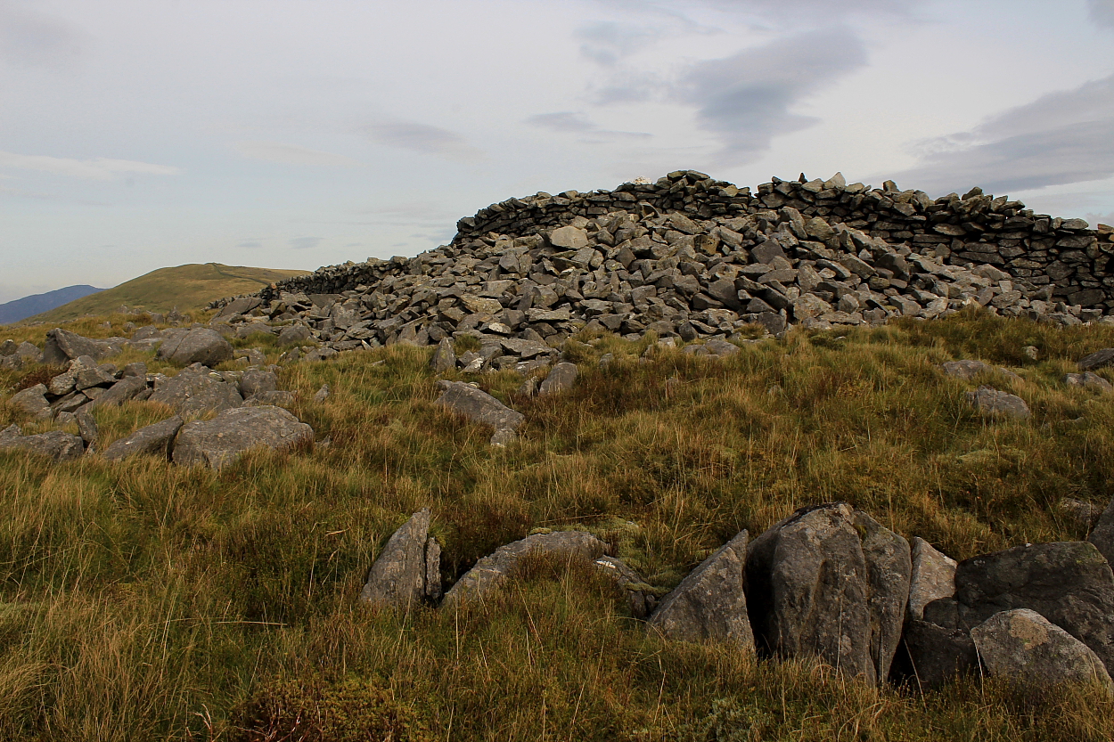
Dodgy conditions, so poor light – but nevertheless a pretty substantial monument, albeit well camouflaged upon the hillside.
Despite being featured upon current OS mapping I’m pretty confident that a visit to the obscure Bronze Age cairn located upon the south-eastern spur of Moel y Gadfa – the high moor ( at 1,669ft) overlooking the minor road linking the mountain pass Bwlch-y-Groes and Llyn Efyrnwy – will not grace many antiquarian-themed itineraries. Ha! Upon second thoughts, very confident...
To be fair, the terrain to be found here – to the east of the magnificent Arans – is probably an acquired taste and, as such, likely to appeal only to those with a penchant for avoiding the crowds and immersing themselves in the landscape – hopefully not TOO literally, one would hope. It is pretty hard going underfoot... but hey, nothing good comes without a little effort, right?
In the event I struggled to find the monument owing to fence lines on the ground not mirroring what was shown upon my map, this disorientating me more than a little as hill fog swept in to further confuse matters with reduced visibility... and driving rain. However, find it I did. Eventually.
Coflein notes:
“A much disturbed & spread round cairn, in the region of 7.5m in diameter & 1.0m high.” [RCAHMW AP94-CS 0027 J.Wiles 26.07.04]
A very obscure Bronze Age cairn between Bwlch-y-Groes and Llyn Efyrnwy, east of the mighty Arans.
The elevated ridges of Esgair Gorlan and Esgair Nant-y-Moch stand to the (approx) south of the enigmatic Pumlumon outlier Disgwylfa Fawr (the ‘Watching Place’) and, as such, are well worth a wander in their own right when events/weather/downright exhaustion conspire against a more challenging outing. Although nothing is indicated upon current OS mapping, prehistoric upland cairns are to be found here. Well, this is Pumlumon, after all. What else did you expect?
I parked up beside the ford overlooked by the cairn namechecking the Nant Geifaes, following the stony byway heading southwest into the hinterland.
Coflein reckons the following:
“Located on a summit on the eastern side of Esgair Gorlan is a robbed round cairn. It is a turf-covered stony mound measuring 9.5m in diameter and 0.5m high but higher on the south-west where spoil from a central hollow has been piled up. The hollow measures 4m long (NW-SE) by 1.5m across and 0.4m deep. It was presumably the site of a cist, or at least thought to be, though its stony base may point to a cist cut into the old land surface.” [D.K.Leighton, RCAHMW & R.S. Jones, Cambrian Archaeological Projects, 29 May 2015]
Note that there is – unbeknown to me at the time of my visit – another cairn surmounting the western summit of Esgair Gorlan at SN7241082620. Another time, perhaps?


So, definitely a cairn, then. Remnants of internal structure are also evident. Esgair Nant-y-Moch, featuring a possible further monument, rises beyond

Anywhere else this was not ideal weather... but for Pumlumon, absolutely fine.

Looking across what was in fact a substantial monument. The enigmatic Disgwylfa Fawr – the ‘Watching Place’ – rises to the approx Northeast.
Come with me, into the trees… yeah, find ‘em if you can.


Looking across the south-eastern stones towards the southern of Y Rhinogydd’s two Diffwys... this example bearing its own Bronze Age monument (albeit an obscure one)

Note two ‘circle stones in the foreground – and possibly related stones right?

Bit distracted after an interesting chat with the farmer arriving on site, meaning this is not the exact angle I wanted to show... however, the ‘entrance portal’ to the Cerrig Arthur ring is (in my opinion beyond any reasonable doubt) aligned upon the great Twll yr Ogof cairn (Craig y Llyn) almost 5 miles to the south-east.

Fading light and very, very windy. What, no rain?


The trio of stones upon the southeastern arc... for what it’s worth, second time around I took this arrangement to represent an entrance portal to what was clearly a ring. As Mr Lydon once said ‘I could be wrong; I could be right’.

Approaching direct from Mynydd Egryn to the approx northwest – Cadair Idris forms the dramatic backdrop across the Mawddach.

Looking down upon the hill fort from Mynydd Egryn, southern Rhinogydd.

Always a fan of aerial views of hill forts... here looking from the wondrously undervalued – and very, very windy – Clip, northern Rhinogydd. The equally wondrous Ffridd Fron kerbed cairn lies unseen (centre-ish), The Lleyn Peninsular rising above Tremadog Bay beyond.
Easily by-passed. I’d recommend that, given the opportunity, members tarry awhile...


Flattened or not, a wonderful viewpoint.

The heart of lower Mid Wales sits upon the skyline...


Looking from what I had mild suspicions could’ve been the remains of another monument to the approx west. However, after viewing the excavation report...

The cairn is somewhat more difficult to appreciate than in Kammer’s images almost two decades prior. I didn’t feel much vibe, although perhaps that was because I was en route to Caer Maurice.

Approx centre of the wondrous be-cairned ridge, looking from Caer Maurice. Esgair Fraith is to the right, with the massive Carn Fawr out of sight beyond the trees to the left..

Carreg y Bwci can be seen (centre, middle far right) below and to the right of the obvious cairns surmounting Esgair Fraith, centre right. Viewed from the wondrous Caer Maurice


Northern flank looking west – wouldn’t have wanted to assault this back in the day.


Looking north – exquisite countryside, to be fair.