drewbhoy

drewbhoy

All posts expand_more 12,301-12,350 of 13,340 posts

Cairncoullie

The signpost, at least on the visit, should have said 100 meters public mud path! It couldn’t rain much heavier by this time but spirits held as the water proofs did their job.

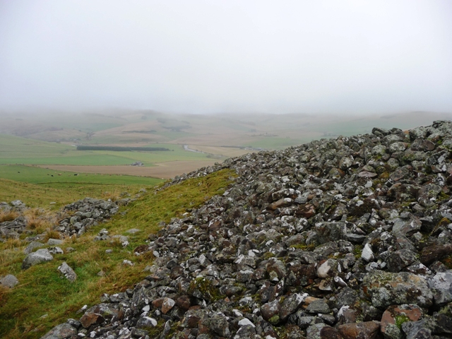
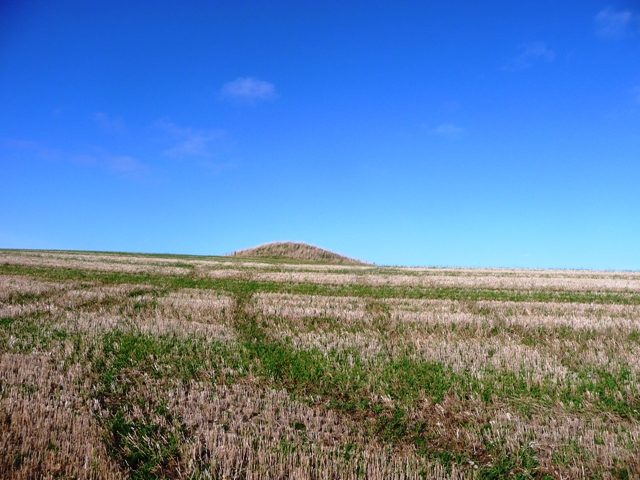
This cairn is an ancient burial ground on two levels. The biggest being about 25 meters wide and almost a meter high. A crumbling dry stane dyke with some kerbs keep the cairn intact. Internally there is a small rise almost 10 meters wide, surrounded by a partially filled in ditch. Once again the views from here would be superb on a sunny day.

Leave the A97 just after Kildrummy Kirk, turning south east towards Brux. Take the first minor road east after Brux. Cairnoullie is at the top of the hill with the sign on the left.

Visited 19/10/09.

Kildrummy Kirk

Turn east from the A97 just before Kildrummy Castle on the minor road to St. Bride’s Church. The cairn is next to road on the western side and is easily spotted thanks to tree that sits on top. Only one kerb remains in place whilst others are scattered. Rabbits and the tree make sure erosion occurs.

At one time the locals looked after the cairn, however the fence that once surrounded it has collapsed. The local church is at the end of the road and is worth a look.

Visited 19/10/09.

Clova 1

This souterrain is almost in perfect condition complete with it’s slab roof intact. The Romans get blamed for trashing most of them, but some escaped, Culsh and Ben Newe are both fairly nearby. Unfortunately it is estimated that more than 80 have been destroyed or ploughed in. Clova 1 is very similar to Tealing, the big difference, apart from the roof, being that the Angus model is getting good care from the authorities. This one isn’t which makes the rock art impossible to find to my untrained eye (I should have taken a torch), the entrance and exit are beginning to cover up with earth and weeds.

On looking down into the entrance I must admit to being scared as I entered the doom. Outside it was chucking it down, inside was surprisingly warm. Internally the souterrain is in fine condition with massive slabs above. Hopefully one day this site will be tidied up as it surely must be considered one of the North East’s best kept secrets.

It is over 200 meters, west, from the Muirs Of Kildrummy in the small clump of trees. Ask permission at the farm, the occupants are helpful and pointed out both sites. Take care not to jump the fence and land straight in it!!

Magical place!

Visited 19/10/09.

Wester Clova

This lovely but fragile looking standing stone stands at just over 1 meter in height and is red granite. It is 50 meters to the east of Wester Clova farm on the banks of the Mossat Burn, beside the telegraph pole.

Travel south from the Muirs Of Kildrummy taking the first minor road right, west. The road ends at Wester Clova.

Visited 19/10/09.

The Lang Stane

This stone can be seen from the cairn at the Mill Of Brux. Therefore follow the road in a south easterly direction until Easter Sinnahard farm. I walked to the top of hill to the west of the farm, to avoid scaring cattle, then turned north. Walk the length of the field with stone being in the middle of the next one. It stands all by itself but is spied on by at least four quite close cairns.

Once again, thanks to Rhiannon and her fantastic folklore!

Visited 19/10/09.

Lulach’s Stone

Thanks to Rhiannon’s notes I finally tracked down this impressive standing stone. It stands at proudly at 21/2 meters. The rain and the mist giving a hint of some bedevilment. However the stone didn’t fall on me!

Travel south from the Muirs Of Kildrummy farm and take the first left. Continue until this track ends. The is stone is about 300 meters further on. Muddy and slightly boggy today.

Visited 19/10/09.

Hill Of Whitecross

This is an overgrown site which will soon be consigned to histories scrapbook. It has been badly robbed, rubbish flung on top and is overgrown with whins and weeds. The only thing going for this site is the view, Bennachie rises up to the south so whoever was laid to rest here certainly had a lovely spot. Also one kerb remains of this 4 meter wide cairn, its difficult to decide on height because of all the obstacles.

Leave the A96 just north of Inverurie and follow the signs to Chapel Of Garioch. Turn south at the village taking the third left, Whitecross is signposted. On the hill there is a small wood, the cairn being a few meters south.

Visited 18/10/09.

Law Of Melrose

Having walked the Macduff to Rosehearty route a few times, I decided to visit the Law Of Melrose by another route. Mistake!

Having parked just after the Newton of Melrose, on the B9031 travelling east from Macduff, farm it looked like a fairly short walk to the cairn. What I didn’t predict was the sharp drop into small valley, boggy at best, with three burns to jump, and a short but steep climb on the other side. Throw in a few barbed wire fences and the walk had become an obstacle course, with one person in the race I still managed to come in second! So much for the short cut.

The cairn has magnificent all round views, the Moray Firth to the north and excellent views east and west (as far as the Black Isle). Cairn Lee blocks the southern view, it’s views to the south are all the way to Bennachie. Grass covers the cairn which is over 28 meters in diameter and 4 meters high. Legend says that executions happened here, as does Canmore, but on checking, at the nearby and useful Banff Museum, no records of this could be found.

Took the same route back to car with my luck holding out. No visits to the burn...boost!

Visited 16/10/09.

Knock Saul

This site, fortunately hasn’t been buried so I didn’t get the unwanted hat trick, is found on top of the Knock Saul Hill which is part of the small Suie range between Leslie and Clatt, Tullynessle to the south. There is a boundary marker beside the cairn indicating this fact. Several shelters have been made in the 12 meter wide cairn. It stands at 1 meter in height. Some stones sit 2 meters out circling the cairn, they might be kerbs but are more likely to be randomly dropped stones.

The views up here are spectacular taking in good views of the Garioch, to the east, Alford to the south, Tap O Noth to the west leaving the north to be hidden by fir trees.

Leave the B992 at Auchleven (Premnay) heading west towards Leslie. At Leslie turn south at the church and keep going until the road ends. I parked before Saul Farm as it is on a private road. Follow the tree line for at least 11/2 miles, tricky stream jump on way, until the Gordon Way is reached. Turn right, west, following the directions to the hills summit, the cairn is beside the path. My walk time was over 2 hours and towards the end it is pretty steep. The path is ok in parts and boggy in others thanks to horses churning up the “dubs”.

Visited 15/10/09.