
drewbhoy


If there is a hard way to do something then I normally find it. Today was no exception, I could of driven to Crowmallie House and had a short 120 meter walk instead I parked near the A96, on a minor road, just short of the Oyne fork. (there is a signpost for the Maiden Stone and Chapel of Garioch, stop at the first passing place on the left. Plenty of room to pull in away from the road)
Follow a path, probably created by shooters, past a second clearing then climb towards the summit. This took longer than expected as the hill is covered in rocks and fairly steep. Happy hunting for Tiompan, I’ll return when I have more time. At one time there also had been a cairn and a stone circle but both had been removed.
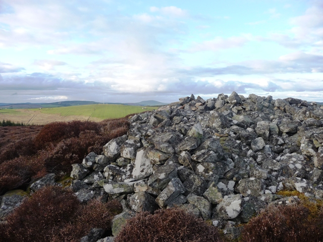
The kerb cairn could have gone the same but didn’t as after excavation in 1961 it was rebuilt. Perfectly situated on the summit of Knockollochie Hill in the foothills of Bennachie. The cairn is almost 8 meters in width and 0.3 meters high. Also there is a sculpture of three metallic tall chaps keeping guard.
With that done it was back to the car, so a short walk had turned into a pleasant afternoons hike of about 2 miles.
Visited 29/04/2010.


Cairn 2.
This is found on the north western side of the summit. A small cairn which has been badly damaged some 4 meters in width, standing less than a 1/2 meter tall. The views over to Ben Rhinnes are worth the walk alone.
Cairn 3.
This is found further along the same plateau. Only a small smattering of stones remain on a small rise some 4 meters wide. Somehow I think this is almost the most important site, great views west looking towards the Cairngorms.
Both cairns have been damaged by rabbits, but they in turn have helped us learn how these sites have been constructed.
To be fair most of the hill is covered in small cairns, as well as bogs. This marked the end of the day, only 4 miles back to the car. This time I walked down the eastern side of the hill arriving at Craighall. From there I headed north back to the B9115, then east to Edinstone and the car. No crutches this time!!
Visited 26//04/2010.


Continuing on from Ten Rood Wood I made my way to Turfhillock, at the bottom of the hill then turned east back along the B9115. Take the first minor road south, leads to Glass, stopping at the first major ‘kink’ in the road. Janetstown is the hill immediately east.
The last time I was here ended in disaster and the shame of being carried back down the hill, then to the hospital. This time the weather was perfect, less than two weeks before this area had been under 2 feet of snow with the unexpected March winter. In secluded areas the drifts still clung on. But I avoided them and like a Spring lamb, hard to imagine I know, jumped all obstacles in the way.
The cairn is on the eastern side of the summit and with all the cairns in this area the views are breathtaking. My foties don’t do the area justice so you’ll have to come look instead. Looking east the cairn stands at 8 meters in width and stands just over a 1/2 meter tall. The people in the know say two kerbs, I say three. We both agree that stones have been removed as evidenced by empty holes in the ground. The middle of the cairn has also been hollowed.
This is probably a three mile walk from Ten Rood. Somehow I missed two small cairns so its back to them.
Visited 26/04/2010


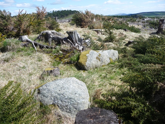
From the cairn on the top of North Whiteley I walked cross country to Ten Rood Wood, about three miles, completely forgetting to go to the Edintore cairn. (to immersed in whistling Glasvegas tunes!) Cross the minor road at Drumgrain farm heading towards to woods in the west. Under foot conditions were mostly fine and luckily I seemed to find gates. (just a couple of fences) After walking thru a thin strip of trees keep to the fence line. A lot of trees have had the chop. For the cairns protection circle of 9 stumps surrounds the site.
There must have been a large kerb here as at least 5 stones remain. one these has had a ‘dunt’ from a machine and is displaced. It is beside the biggest kerb, a stone almost 11/2 meters in length by a 1/2 meter tall. The cairn itself is some 12 meters in width. Far below in valley is Turfhillock farm, further down the road is the village of Drummuir which has no shop. So stock up before walking.
Edintore will have to wait just a wee while longer.
Visited 27/04/2010.


Walking in a north westerly direction from Whitley A, maybe 300 meters approx, another cairn sits on top of the hill. These cairns marked the start of a very long days walking. For me, the fresh air and scenery, inspiring.
A long, long time ago this must have been some place. Ben Rhinnes, west of Dufftown, Durn and Knock Hills, to the north can be seen. On a good day Bennachie.
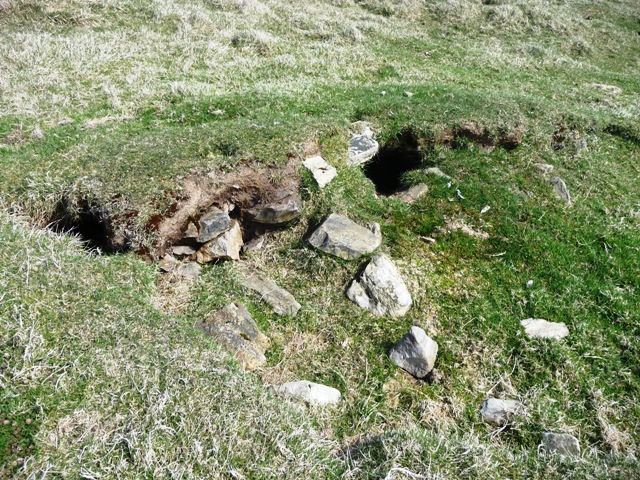
The cairn has been built on top of a robbed platform which sits at some 24 meters in diameter. On top of this was placed the cairn at almost 14 meters wide being only a 1/2 meter in height. One kerb remains, thanks to rabbits (I assume), chokes can be seen underneath. Quarrying has damaged both the platform and cairn. A trig point has also been built on top.
Whatever has happened to this place has happened but the vibes remain. I feel in top form, the legs are well, the sun is out and for a change no music just the sound of various birds chirping to themselves. Probably saying who’s the idiot in the green hat! On to the next site.
Visited 27/04/2010.


There isn’t much left of the 10 meters wide cairn except the scenery which is stunning. A 2 meters wide rim survives which has been interrupted by a badly ruined dyke. The centre is hollow and has been obviously robbed but what for isn’t so clear. Apart from the remnants of the wall hardly any dykes are in the proximity. Sadly it looks like the stone crushers have had a field day here. Fortunately all isn’t lost, they can’t take away the views and the original ideas.
Travel south from Keith on the A96 turning east at the B9115 Drummuir road. I stopped just short of Edintore farm. Follow the tree line north, be careful at the boggy bit at the top. Look east and follow the remnants of the dyke towards the small wood. The cairn is a 100 meters before the trees. From the road a fairly steep climb of about a mile.
Visited 26/04/2010.


My second cup marked stone find. This time much closer home, and the sun shone. Lovely!
After finding the cairn I noticed a lot of flat rock surfaces and my luck was in. On the crest of the hill facing towards Bennachie is a rock with 5 cup marks. 3 are very noticable being about 8cm wide and 2cm deep. Two other weather worn cup marks can also be seen. Backley Hill is covered with this type of surface but these were the only cups I could find. However like the fairly close New Craig I wonder whats under the turf. With Bennachie in perfect view.............
I must thank George Gauld and his wife for allowing me to park at the farm. Also for showing me a very old map which indicated the nearby Elspet’s Cairn and a long forgotten about and destroyed stone circle at Crowmallie. So thanks to them, very interesting.
Visited 24/04/2010.


I reached Backley by approaching from the north leaving the B9001 following the road to Wartle then Durno. At Durno turn in a north easterly direction, Backley is on the first farm track to the right (north). I parked at the farm, with permission.
The remains of the Bronze Age cairn, and I emphasise remains, are on the south east of the hill. All that is left is a small mound about 11 meters wide standing at a 1/2 meter in height at it’s tallest. Maybe one kerb remains along with a scattering of stones lying on the grass rise. Bennachie is bang in front and probably played a part in it’s positioning, as with another discovery I made.
Visited 24/04/2010.


The former Church Of Scotland minister at Aberchirder the Rev. Bob Jones told me about this stone as well as the history of various circles in the area. Canmore says it might be fairly modern but he insisted that it was the real thing and possibly might have been removed from nearby Marnoch Church or Bellmans Wood.
It overlooks the River Deveron and is in prime stone circle country so the old chap is probably correct. Certainly people in the village of Aberchirder are keen to emphasise its age.
It stands at a good six feet on height. Leave Aberchirder going south, Foggieloan to us locals, on the A97 immediately turning left after crossing the River Deveron at the Marnoch Bridge.
Visited 23/04/2010.

