
drewbhoy


After the disastrous attempt of last summer, hours and hours toiling away in hot conditions getting nowhere, an alternative route was required. Thelonius suggested an alternate route which I think I followed. (thank you)
Head east from Dinnet taking the first track north indicated St James. Follow the road until the track veers east towards the last house. This leads to the ruined farm of Knockenzie. By this time Mulloch Hill will have been passed so head north thru a field until the heather appears and head up hill. A path eventually appears which leads straight to the cairn, on the west of the hill.
This would have been perfect for the hillfort but the cairn has pride of place with tremendous views over to Loch Kinord and Morven, in fact good all round views. The cairn is some 15 meters in diameter and 1.4 meters high. Almost unbelievably easy after last years trials.
From here its a long walk east to take in several other cairns.
Visited 14/4/2011,


Just to prove that spring has arrived up here as well.
Image credit: drew/amj


Conservation work to restore and preserve ancient woodland has been boosted by funds from Scottish Natural Heritage.
More info :
Some place, some history, brilliant.
Head west from the village of Glenkindie (A97) taking the second entrance, to the north, to Glenkindie House. Pull in at the first gate to the north. The souterrain is in the fenced clump of trees in the middle of the field.
It is in excellent condition as the locals said, being some 10 meters in length and 1.8 meters tall. Once upon a time a cairn covered this site but it has long since vanished leaving the fantastic site unblemished. All the details are in the Canmore link below.
Wonderful site, wonderful start to the day albeit a very early start.
Visited 14/4/2011.

In amongst the trees. There once was a cairn here as well.
Image credit: drew/amj


Old Fred Coles suggests that this might have been once part of a circle. There are boulders scattered nearby and a quick look of nearby dry stane dykes didn’t reveal any circle type stones so this would have to go into the might have been but unlikely category. However it is a beautiful stone in a beautiful valley just along from the Coleburn Distillery. Standing at over 1 meter in height it has almost the width at the bottom gradually tapering to 0.5 meters at the top.
Once again nice scenery being located between Hart Hill (to the west) and Brown Muir Hill (to the east). Head south from Elgin on the A941 going thru Fogwatt and past the Coleburn Distillery. When the trees stop on the distillery side stop, the stone stands beside the fence and trees some 50 meters from the road.
Visited 12/4/2011.
This site is a tragedy and a severe disappointment after Davie’s Castle Fort and the unexpected Upper Auchenreath. If there are any standing stones then I didn’t find them. I looked everywhere with jabbies and whins taking full revenge on my legs. What is left is a badly mutilated cairn with stones possibly buried underneath a pile of vegetation. Still it must have been a nice place in its day with nice views west to the Black Isle and north, to the Moray Firth. I’ll go back and look in winter maybe something will turn up apart from me.
Continue up the road, north, from Upper Auchenreath. Turn west at the crossroads and go about 100 yards, the cairn is on the other side of the road.
Visited 12/4/2011.


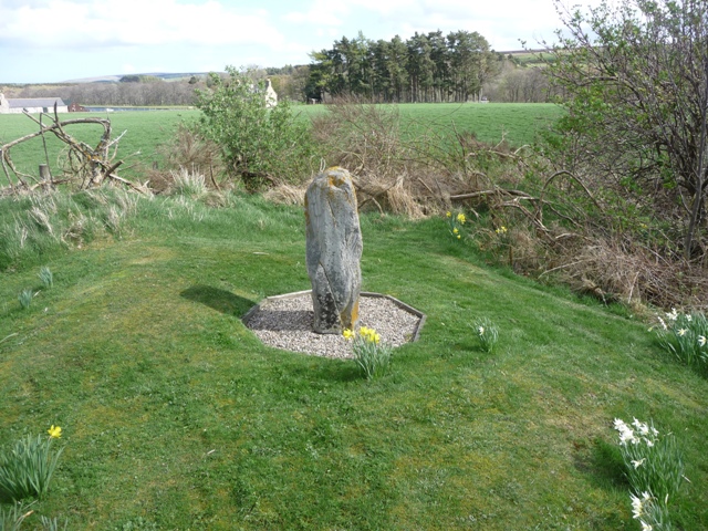
As the alternate name suggests a chapel once stood in this area and near it also stood this 1 meter high standing stone. The stone was moved slightly to the east to allow for the erection of the war memorial. With Spring in the air and daffodils adding welcome colour, this is an attractive little site.
Go south from Elgin on the B9010. Kellas is the first small place on the road with the site near the war memorial slightly to the eastern side of the road.
Visited 12/4/2011.


Go west from Buckie on the A98 taking the minor road north at the Mill Of Tynet handily placed near a hotel. Upper Auchenreath is the first farm track east. Go the end of the track, then head north to the second field. The cairn is slightly to the west.
As its alternate name suggests some kind of justice was carried out here. Canmore seem to do it an injustice by saying a small cairn some 18 meters wide once stood here. I’d like to know what they think is big!
To me the satisfying thing is that there are any remains at all. the present farmer must take a massive amount of credit as it looks like he takes care of the site. I know that he puts poles up to mark the site so it doesn’t get any further damage during harvest. So good on him.
The site is about 18 meters wide and is 0.5 meters high with views to the Moray Firth and maybe more importantly south east to the Hill of Maud.
Strange to be happy when there isn’t much to see. Then again it’s good to learn that some people care.
Visited 12/4/2011.


Looking South East, the Hill Of Maud in the background.
Image credit: drew/amj

From A98 just before Cullen head south on the B9018 thru the village of Lintmill until the first minor road west at Nether Blairock farm. From here go for a mile (approx) until the first corner. Stop here, as forestry roads lead to the site. Walk a few yards and take a the track going in a north easterly direction. This is a beautifully quiet place, a stark contast to noise of the match I’ve just been to and the singing on the bus (1-0 us). But a great way to start the day. Its early morning and the this part of the world, at least, is tranquil. Follow the track for another mile and the tree clearing narrows and a hill appears. Cross over and climb.
Most of the rampart seems, to me, to be in quite good condition. The west heads north to arc round and head south in the east to eventually end with an abrupt drop into quarry. The ditch/rampart height must average at 4 feet all the way round except for the two ditches at the southern flank. A possible entrance is in the north. The fort’s interior is now covered in trees but in the middle there seems to be usage. A small circle of stones contains a couple of skulls and limbs of something. Seems pretty deliberate to me. Some kind of sacrifice, I hope not but I don’t know much about these things so I can’t really comment.
So with that done it was a pleasant walk back to the car from a site that I found quite inspiring for reasons I don’t know why. Time for a few more sites before catching the supporters bus to Perth for tonights game.
Visited 12/4/2011.


The north rampart ends with a drop into the eastern quarry.
Image credit: drew/amj

The end of the north sided rampart/ditch at its southern end. Beyond that is a sheer drop into a quarry.
Image credit: drew/amj


