
Grennan Hill fort taken from nearby Tynron Hill. The fort is situated in the middle of the two larger hills.
Image credit: Ian Freeman
Grennan Hill fort taken from nearby Tynron Hill. The fort is situated in the middle of the two larger hills.
The Actual Name of the place is Holywood.

The Twelve Apostles of HOLYWOOD
Ballard Down Barrows is a group of two round barrows and a pond barrow situated on the east Dorset coastal path between Swanage and Old Harry rocks.
A bronze age bowl barrow. I would say it is just over a meter high as you can see it above the oil seed rape wich surrounds it. it is situated 300 yds south of Goddards Barn below the ridgeway, thus the name.


A tumulus near Pewit Farm, Lockinge, which is encroached upon
the south by the Ridgeway, was excavated by Stuart Piggott in
1938.
The barrow, more than half of which had been removed to within
a foot of the surface by the farmer, was found to be of
bell-type with the mound c. 44 ft. in diam. and the ditch c. 90
ft. in diameter.
Early-Middle Bronze Age sherds were found in the mound some
being of such a nature as to suggest that they were scooped-up
material from a hut floor or occupation site and not purely
funerary. There was a central oval grave, 5 by 3 by 3 feet
deep, which appears to have been plank-lined, and which
contained a cremation accompanied by a bronze awl and bronze
rivetted dagger which suggest transitional Early-Mid Bronze Age
date.
One of the many barrows locally to be found on the Ridgeway path. The barrow is the remains of a Bronze age bell barrow situated near to Pewitts farm above Wantage. It was excavated in 1938 and there were several finds dating it to the mid Bronze age.


Memorial to Civil War dead on top of one of the eastern barrows

Confusion as to the dating of these barrows occurred with the dedication of the area as a Recreation Ground on Jubilee Day 1897 by the Mayor of Newbury, Robert Long. Two of the mounds in the barrow cemetery have dedication stones on them, one of which is ‘Sacred to those who fell in the Battle of Newbury, Sep 20 1643’. From this local legend grew that the three burial mounds contained the dead of that battle, one for the Roundheads, one for the Royalists and one for the horses, but it is believed that the Civil War dead were buried on Round Hill some 300 yards from the barrow cemetery.
A group of five round barrows on Wash Common. Probably of Bronze Age origin, although local tradition identifies them as burial mounds for soldiers killed during the English Civil War Battle of Newbury.
The individual monuments comprise: a circular enclosure defined by bank with external ditch (possibly a saucer barrow?); a large bowl barrow surviving to 2.7 metres in height, surrounded by a ditch; another bowl barrow previously described as being 2 feet high and 22 paces across, but which has been destroyed and two further bowl barrows, and measuring 1.6 metres in height

Bowl Barrow to west of site

The 2 Bowl barrows to the east of the site. Both have plaques commemorating the Civil war dead on the top.


Remains of the destroyed Barrow
Three round barrows situated in the south-west corner of
Woolley Downs, Chaddleworth, between the parish boundary and the
Hungerford-Wantage road, were excavated in 1933.
Barrows A and B were similar in construction, consisting of
deep circular ditches, seventy and ninety feet in diameter
respectively, the spoil being thrown up to form rings of rubble
inside.
No interments were found in A, but B. contained an empty pit
near the centre and an undated secondary cremation in the chalk
ring.
Finds from A and B included Romano-British pottery, and sherds
ranging throughout the Iron Age. Barrow C contained pottery
fragments of both these periods plus one beaker sherd and
several pieces of Early or Middle Bronze Age pottery. They may
have been erected as early as 400 B.C. but more likely about
the beginning of the Christian era.
Their purpose, which was not determined, may not have been
sepulchral. Associated occupation debris dates until the second
century AD.
[C.SU 3991 8046] Barrow C was quite different from A & B and
appears to be a Late Bronze Age “scraped-together” barrow. Two
empty pits were found beneath the barrow and a double
inhumation burial, possibly Saxon, across the ditch.
Situated on The A338 Wantage to Hungerford road by the turning to South Fawly there 3 barrows in total. The oldest is the believed to be from the late Bronze age and the larger 2 from the Iron age. The site is overgrown so i couldn’t find the smaller of the 3 barrows. There is a footpath that runs past barrows so access is not a problem.


A large, irregular and apparently ditchless bowl barrow situated in a field east of Rowbury Farm. Excavation by a Dr Palmer in the 19th century reportedly found only charcoal and ashes. The mound now measures circa 26 metres by 15 metres and is a maximum of 1.25 metres high, and has been considerably dug away onthe southwestern side. Numerous flint flakes have been reported from the surface around it

Barrows to the east of Churn Farm taken from the Ridgeway. These barrows are Known Locally as the Warrior Barrows.


Visited this site whilst on trip to Quarley hill. I found 5 Bowl Barrows in total but there are 12. They vary in Height from about 0.5 to 3 meters. Most are covered in scrub but are near to the Cholderton Road or the footpath to the Lodge so are easy to access. There are 2 more to be found in the garden of a private house one of which looks like a disc barrow in the aerial photos. A nice site in an area full of prehistory on the edge of Salisbury Plain

Quarley is a univallate iron age hill-fort with well defined entrances at north-east and south-west.
Lovely site commanding great views all around. Lots of prehistoric activity in area including large ditches radiating from the hillfort believed to be part of a bronze age farming settlement and a barrow cemetery about a mile away to the north. The best view of the site is as you drive past on the A303 going west but alas not ideal for stopping to take a piccie.
A bronze age univallate hillfort. Visited the site today and not a lot left apart from a raised bump in the field on the south west corner about a meter high. But still quite visible if you know what your looking for. Originally triangular in shape much has been destroyed by the A303 and housing
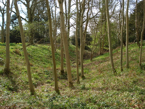
Earthwork remains of an Iron Age univallate hill fort. Greatly worn down now The banks are now covered in woods and shrubs and are best preserved on the southern side. The original entrance still exist on the south east corner.


Ramsbury corner situated near Cold Ash in Berkshire is believed to have been a small univallate hill fort. The site has been greatly ploughed down but the boundaries of the site could be followed when I walked it particularly the northern edge that follows the road and to the west and south of the site. There was also a bank and ditch on the other side of the road to the north which I believe could be original. A shame that the site has been so cultivated and continues to be.


Bussock Camp, is an Iron Age bivallate Hillfort situated near Snelsmore common near Newbury. It has a double bank and ditch on the south and east, with only a single bank remaining on the north and west. There is a lane running through the middle of the camp providing access to the private property on the eastern side of the woods. The Entrance to the north of the site is believed to be the original.


