
The view from the other side, Eve and Adam.
Image credit: A. Brookes (19.7.2013)
The view from the other side, Eve and Adam.


Adam and Eve, natural monoliths on the summit of Tryfan.

Postie surveys the Carneddau from Tryfan’s rocky summit.

Tryfan summit from the South Peak, note plenty of people waiting their turn to climb onto Eve to make the leap across to Adam.

Serious views of southern Snowdonia and its many high-level funerary monuments, all the way to distant Pumlumon, can be had from Tryfan on a clear day.

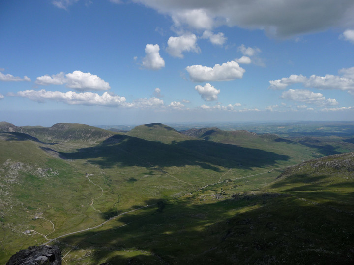
The proto-temple of Castell y Gwynt hides behind the bulk of Glyder Fach, left of centre. But the Bristly Ridge route up to the site can be seen, rather terrifyingly, to the left of the shot. There are other ways up...
Some further landscape context. The mountain is slightly left of centre, the cairn under fleeting shadow, the viewpoint is Tryfan.

Dragon’s shadow passing over the settlement site.

Further landscape context and a fair-weather companion to Gladman’s image. The Ogwen Valley curves away NW towards Ynys Mon, with the western Glyderau (Y Garn, Elidir Fawr, Foel Goch, Mynydd Perfedd and Carnedd y Filiast) flanking the valley’s side.

The rocky flank of Pen yr Ole Wen towers above the site, the approx position of which is indicated.


Coflein mentions possible cist elements.


There is some quite substantial stonework in the mound, but structure is difficult to ascertain through the vegetation.


Cairn I, looking towards Tarren Maerdy.

Cairn I, looking towards the summit of Mynydd Ty’n-tyle.

Cairn I, the southernmost of the group, looking across Rhondda Fawr.

The top of Cairn II, showing small exposed slab (see misc. post).

The western side of Cairn II, showing the bedrock “kerb”.


Cairn II (the central cairn of the group of three). Looking SE.

Visible cairn material of Cairn III. Looking NW towards Tarren Maerdy, with its own pair of cairns.

Cairn III, looking towards Cairns I and II. Across the Rhondda Fawr valley, on the hillside far right, is the Mynydd y Gelli complex.

Cairn III, the most northerly of the group. Looking SE towards the strangely cairn-less summit of Mynydd Ty’n-tyle.


The better Cairn I (SW). Looking SSW across Rhondda Fawr, on the hillside opposite is the Mynydd y Gelli complex.

The rather nondescript Cairn II (NE), looking down to a sun-bleached Llwnypia in the Rhondda Fawr.

Cairn II is situated just below the rise, Cairn I is on top of it, but not visible from here.


Stonework in Cairn II. The leaning slab in the centre is the one referred to in the Coflein record as possibly a cist side-slab.

Unlike the more elevated Cairn I, Cairn II has a view down to the floor of Rhondda Fach. The town is Ferndale.

Tarren Maerdy Cairn II (SE), looking SE towards Mynydd Ty’n-tyle, which has further cairns.


Looking SW towards the newly-erected windfarm and the cairns of Mynydd Ty’n-tyle.

Looking east across the Rhondda Fach. The valley floor is not visible from the cairn.

Cairn I (NW), an inconspicuous mound concealing a gem of a cist.
The final site of the day proves to be a winner. By the time we reach Bannau Sir Gaer, all but one of my friends has had enough, and don’t even make the effort to leave the path the look for this. The one who is left at least comes to the circle, but isn’t massively impressed, to be honest. Which just shows that this game isn’t for everyone!
And so it comes to be that I’m left here on my own for a while, just as the sun re-emerges to illuminate the site in a golden glow, while the mountain backdrop is silhouetted into a wall of dark browns and black shadow. Spectacular. The circle is a wreck, it doesn’t matter a bit. A fine addition to the utterly compelling megalithic complex spread across these wild uplands.
One of the main attractions of this walk for me, apart from the brilliance of the summit cairns, is the two stone circles shown on the OS map along our return route. The second, Bannau Sir Gaer, is the better known, already visited and chronicled by Postie. But the first is virgin TMA territory. Coflein are dismissive of the site, and on getting here it’s easy to see why.
We found the narrow track that the OS map shows as bisecting the site easily enough, but it crosses an area of plentiful small stones. Some are vaguely upright, but it would take a determined eye to be convinced that there is a circle here, unless we’ve missed something. My companions were certainly not impressed! Not far from the site, we came across a neat little spiral of blocks, half-hidden in the tufty grass. Someone has spent time here, to make that. To be fair, the setting is lovely, with the pointed prows of be-cairned Twr-y-Fan Foel and Fan Foel providing the main focal points. To the north, the land gradually slopes away towards Nant Tarw, although the circles aren’t visible from here, as far as I could tell.
We head away from the setting across the tussocky, peaty moor of Waun Lwyd, close to the source of the river Usk/Afon Wsyg, one of South Wales’ major rivers, which passes close to the Nant Tarw circles as well. It may be significant that the Tawe, another important river, rises not far away to the east, before passing Cerrig Duon & The Maen Mawr. There’s certainly plenty of scope for water-based theory and speculation about the siting of these monuments.
From Fan Foel, it’s not far at all to the next of today’s cairns, Twr y Fan Foel. Last time I came here from Fan Hir, a walk that is do-able using the Neath-Brecon bus service, but there’s no doubt that today’s approach is more satisfying. The cairn itself is a bit of a wreck, eroded at its base and piled into a silly cone. Purely as a structure of earth and stone, it lacks the charm of the wonderful ring on Fan Foel. But the view is astonishing. The ground drops away to north and east, and this is perfect viewpoint for the second of today’s mountain lakes, Llyn y Fan Fawr. From up here, it’s hard to believe that the lake itself is located at as-near-as-dammit 2,000 feet up. The cairn is at the highest point of Y Mynydd’s Du magnificent escarpment and boy, what a place for a monument. Worth every bit of energy and effort to get up here.
Sadly we don’t linger so long at this one, my companions are getting hungry and a bit further along the escarpment, at the southern summit, there is a drystone shelter that has been identified as our lunch spot. There’s nothing on Coflein to suggest that this shelter has been fashioned from an ancient cairn, so I can feel relaxed about making use of it. For all that the sun is shining, it’s still bitterly cold up here and a stop of any duration is going to see a sudden drop in body temperature. It’s here that we meet the only other people that we’ll see today. Not far to the SW of the summit is the spot where an Avro Anson crashed in thick cloud and rain, back in peacetime 1939, a stark reminder of just how bad the weather can get in and above these mountains.
The route from Picws Du to the next cairn, on Fan Foel, is easy enough but includes a fairly steep up-and-down, via Bwlch Blaen-Twrch (“pass of the boar’s summit”). Once negotiated, there is a fine high-level retrospective view of Picws Du summit before we head over to the magnificent cairn placed right at the apex of the escarpment, the point where Carmarthenshire meets Powys/Brecknockshire.
Was this always a territorial marker? If it was, it’s a high place for the people of power to agree upon their frontier. And perhaps such a person was laid to rest here, interred within a sizeable kerb of red sandstone blocks. If he or she were the monarch of all they surveyed, they certainly ruled over a far-reaching territory, for the views are extensive indeed, stretching eastwards to the twin summits of Pen-y-Fan and Corn Du then further away to the Black Mountains, with many other cairned summits in between. And yet the archaeological record reveals perhaps something rather more intriguing and human than a story of powerful warriors. A child was buried here, possibly garlanded with meadowsweet flowers. If only these stones and mountains would share the memory of that little sliver of history, what a tale they might tell.
This cairn is ignored by many walkers, hurrying between the “tops” of Piws Du and Twr y Fan Foel/Fan Brycheiniog. But sadly enough come here to cause damage to the structure, which is what prompted the excavation and exposure of the magnificent kerb and half-buried cist. Probably the best of cairns on the main escarpment of Y Mynydd Du, this place will richly reward any TMAer making the trip.
As the Picws Du summit cairn comes into view, it becomes apparent that it has a very decent sized footprint, but is now quite low, with a smaller walkers’ cairn plonked on the top, possibly/probably made from stones from the original monument. There are some pretty big blocks in the original though and the footprint suggests it would have been a big cairn. In any case, the setting more than compensates for any deficiencies in the cairn itself. The views north over the escarpment edge are awe-inspiring, even on a day of fairly short visibility like today. And as we stop to take it all in, the mist lifts properly and blue skies open above us. Ah, what a wonderful world. And what a place to be interred.
Incidentally, the name is obscure – the Nuttalls translate it as “Black Peak”, but I’ve not managed to find a translation for “picws” in any Welsh dictionary yet, so I’m not sure of this. Any ideas?

The breathtaking summit setting of the cairn, above plunging cliffs.
