
thesweetcheat


Mynydd Allt-y-grug is the prominent hill to the right of centre, the Tawe valley separating it from Mynydd Marchywel on the left. Seen from the slopes of Cribarth.
Image credit: A. Brookes (3.8.2013)
Exploring the submerged landscapes of Prehistoric Wales.


Two cairns at the southern end of the Cefn Mawr ridge, to the east of the Gwys Fach and (in the case of the northern cairn) intervisible with Llorfa menhir. Coflein descriptions:
Cwm Fforch-wen (SN78861400)
Situated on the crest of a ridge lies a disturbed cairn. It consists of a stony mound measuring 7m (NE-SW) by 6m and 0.3m high. Towards its SW edge lies a slab, embedded in the cairn, which measures 1.6m long, 0.2m thick and with a height of 0.3m above the mound. Aligned NW-SE, the slab is perhaps the remains of a cist.
Llorfa round cairn (SN78731379)
A small cairn lies on roughly level ground on the broad crest of a ridge, a short distance from field walls and sheep folds. The turf covered mound, topped with loose stones, measures 4m in diameter and about 0.4m high. On the immediate N there is a broad band of stones which appears to demarcate the relatively clear ground to the S from the more stony ground to the N.
Description and photos of the stone, possibly associated with stone circle and nearby cairn.
Description of the site, on Roborough Down next to the Plymouth – Yelverton road (A386):
Early Iron Age Camp.
The camp is formed of circular earthworks; there is no evidence of any stone being used. The outer bank is 100 yards in diameter, the smaller one, or Keep, 100 feet across. To the south the inner bank is still further protected by a sickle-shaped breastwork or agger. The camp is approached by two embanked ways, one from the main road, the other going north east from the camp, crossing both the Buckland road and the main Plymouth-Tavistock road, and can be traced to the south-eastern end of the golf links. The inner bank has been heavily planted with hawthorns and may well have been used as a pound for stray animals. There is also a small secondary earthwork, 50 feet in diameter, across the road opposite the banked trench, and a long embankment. The camp was almost certainly used as a beacon; on Spry’s 16th century map of Plymouth Leat it is marked as Rowben Beacon.
The air photograph shows Saunders’ map to be conventionalised. The inner enclosure, “The Keep”, is not concentric with the outer rampart but lies to the east of its centre : within it appears to be two small circular enclosures with a rectangular enclosure against their north west sides. The “breastwork” appears to be earlier than the outer rampart and to have extended, formerly, to the west where there is a trace of a low bank. The “embanked trench” does not appear to extend beyond the road at SX 50676421.
The Path rejoins the Dyke south of Orsedd Wen. The next section of the earthwork is once again particularly fine. Just after it passes through a little wood, a footpath heads off eastwards and will take us to the second Bronze Age treat of the day, which can be seen from the Dyke.
Standing 2m tall, Carreg-y-Big is probably Shropshire’s tallest standing stone, just topping the large pillar at Mitchell’s Fold to the south. The name looks like it should mean “The Big Stone”*. Damn accurate with their names, these Welsh folk (I know, it’s not in Wales). I was mainly aware of this one from Postie’s lovely snow-bound pictures from a year and a bit earlier, but it looks equally impressive in watery Spring sunlight.
I’m particularly taken with the quartz vein running through the stone, being a sucker for a bit of quartz. There is also evidence of packing at the stone’s base. The positioning is slightly obscured from the east due to a hedge, but otherwise the stone would be prominent and just the kind of thing that could be used as a way marker, perhaps pointing the way to nearby Selattyn Hill ring cairn. Cynynion, a further, very similar, stone lies a mile and a half SSW.
Now comes the biggest hill of the day, one I’m looking forward to greatly as it boasts the first prehistoric site we’ve been to since leaving Castell Dinas Bran. It only requires a short diversion off the Path to reach it, through an area of recently felled forestry. Standing at a reasonable 372m, the summit of Selattyn Hill is high enough to command excellent views into Shropshire, as well as of the Berwyns to our west and (I think) the Breiddins to the south. Seeing the former gives me much pleasure, as we sure didn’t see much when we were on them!
The monument here is a ring cairn, sadly much trashed by the plonking of a stupid Victorian tower (now itself ruined) in its centre. However, traces of the stonework that comprised the ring can still be seen protruding through a heather covering. The construction is a wide bank of large blocks of stone, and would have been pretty impressive without the tower. It is best seen on the northern arc, the southern being very overgrown. It’s a great spot though, now that the surrounding forestry has been felled to open up the views, and should be even better once the resulting debris has started to break down. There is another cairn (Orsedd Wen) on the next hill to the west, but we can’t make this out today. It is also noticeable how few footpaths there are on the Welsh side of the border here.
Whatever the post-Roman politics of the Welsh border, Selattyn represents a natural frontier, as the last hill above 1,000 ft before the drop down to the Cheshire/North Shropshire plain to the east. Certainly a worthy place for the twelve urns containing burnt human bone, found here when the tower was built.
At length we head off south, alongside an ancient field boundary composed of huge boulders and an equally large field clearance heap. I find a small sliver of flint on the path, apparently worked (but broken) and certainly not native to this part of Shropshire.


Castell y Gwynt seen across Llyn Llydaw from Y Lliwedd.
Image credit: A. Brookes (9.4.2011)
A NNW-SSE linear group of seven cairns crossing a hillside south of the Afon Ceiriog. Coflein descriptions (NNW-SSE):
Graig Wea I (SJ23893757)
A rather irregular, sub-oval cairn, c.15.5m NW-SE by 14m, and 0.9m high, much disturbed.
Graig Wea II (SJ23883745)
A round cairn, c.8.2m in diameter and 0.8m high, slightly disturbed.
Graig Wea III (SJ24053710)
One of a pair of round cairns found in close proximity (see also Graig Wea IV), c.20m in diameter, very much disturbed.
Graig Wea IV (SJ24093711)
One of a pair of round cairns found in close proximity, c.13m in diameter and 0.6m high, disturbed.
New Buildings I (SJ24323666)
One of a linear group of three cairns, c.11m in diameter and 0.7m high, ruined.
New Buildings II (SJ24353660)
One of a linear group of three cairns, c.10m in diameter and 0.4m high.
New Buildings III (SJ24403659)
One of a linear group of three cairns , c.12m in diameter and 1.3m high, disturbed.

General view of the cairn looking NW.
Image credit: A. Brookes (27.7.2013)

Looking NE across Rhondda Fawr. The distant Brecon Beacons can just be seen from the cairn, far left skyline.
Image credit: A. Brookes (27.7.2013)


Looking SW towards the oddly cairn-less summit of Mynydd Pen-y-graig.
Image credit: A. Brookes (27.7.2013)

Mynydd Maes-teg from Mynydd Pen-y-graig to the ENE.
Image credit: A. Brookes (27.7.2013)


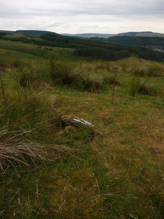
Looking east across the cairn. The most substantial part of the mound is the northern arc (left of picture) and it occurred to me that this could possibly have been a ring cairn. Small “kerb” stone from previous shot visible lower left of centre.
Image credit: A. Brookes (27.7.2013)

What appears to be remains of kerbing on the northern perimeter of the cairn.
Image credit: A. Brookes (27.7.2013)

Reprise of image from 3 years ago, showing the cairn in the foreground and the drastic change in surroundings and view.
Image credit: A. Brookes (27.7.2013)

The mutilated cairn from the south.
Image credit: A. Brookes (27.7.2013)

Looking WSW from the cairn into the Ogwen Valley/Ogwr Fawr.
Image credit: A. Brookes (27.7.2013)

Large slab buried in the cairn’s large footprint. The stack of stones is not a shelter, but rather a solid cylinder.
Image credit: A. Brookes (27.7.2013)

Looking northwest towards Werfa and Crug yr Afan.
Image credit: A. Brookes (27.7.2013)

Since my last visit in 2010, the cairn has developed a new backdrop.
Image credit: A. Brookes (27.7.2013)

Looking NW back towards the forestry track/fire break.
Image credit: A. Brookes (27.7.2013)

“Kerbing elements on the southwest” (see Misc.) of the southwestern cairn.
Image credit: A. Brookes (27.7.2013)

The fallen, “partially dressed” outlier to the SSE of the circle, looking towards the circle.
Image credit: A. Brookes (27.7.2013)

A general overview of the site is almost impossible with the grass as long as it is in summer, so I resorted to artificial help. A stick, map-case, walking pole and rucksack mark the position of stones in the northern arc.
Looking northeast towards Maindy Camp and up the Rhondda Fawr. The setting is excellent.
Image credit: A. Brookes (27.7.2013)

Small stones, long grass. Not the easiest combination for finding the circle!
Image credit: A. Brookes (27.7.2013)

The southern arc of the circle, looking ENE across the Rhondda Fawr towards Tarren Maerdy, with its own cairns and new windfarm.
Image credit: A. Brookes (27.7.2013)

Stone in the southern arc of the circle, looking west towards afforested Mynydd Ton.
Image credit: A. Brookes (27.7.2013)

Looking down into the cist, one the circle stones of the southern arc in the background.
Image credit: A. Brookes (27.7.2013)

The small, overgrown cist inside the ring.
Image credit: A. Brookes (27.7.2013)

The stones of the circle are not large – this is one of the bigger ones!
Image credit: A. Brookes (27.7.2013)

Second time lucky. Here it is, looking SSW across the circle.
Image credit: A. Brookes (27.7.2013)

If you find the stone face, you’re in the right area for the circle – it’s northwest of here.
Image credit: A. Brookes (27.7.2013)

Approx. landscape context for the cairn, from Blaen Clydach on the opposite side of the Rhondda Fawr.
Image credit: A. Brookes (27.7.2013)

What a difference some shears and hard work has made.
Image credit: A. Brookes (19.7.2013)


Looking southeast to Moel Eilio (the Carneddau one, not to be confused with the mountain in the Snowdon range).
Image credit: A. Brookes (19.7.2013)

Looking approx. SSW. Could the slabs in the foreground be remnants of kerbing? I’m not sure what the pointy mountains on the centre skyline are either, anyone help?
Image credit: A. Brookes (19.7.2013)