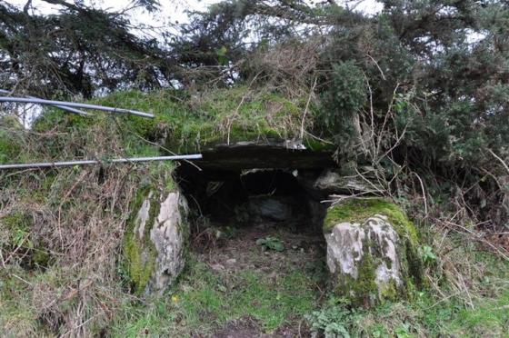
The Modern Antiquarian
Log in
|
Register
Home
Latest Posts
Forums
Maps
Help
Browse Sites
News
Blog
Contributors
The Books
Select
-
Belgium
Denmark
Eire
France
Germany
Greece
Italy
The Netherlands
Norway
Portugal
Republic of Malta
Spain
Sweden
Switzerland
United Kingdom
County Tipperary
Longstone
Longstone
Longstone
Bank Barrow
Longstone (Bank Barrow) on The Modern Antiquarian, the UK & Ireland's most popular megalithic community website. 1 image, plus information on many more ancient sites nearby and across the UK & Ireland.
Image © Bawn79
Nearest Town:
Emly (6km SSW)
OS Ref (IE):
R797392 /
Sheet: 65
Latitude:
52° 30' 14.12" N
Longitude:
8° 17' 56.33" W
Added by
bawn79
Images (1)
0 discussions
Start a topic
Show |
Hide
Web searches for Longstone
Flickr
Google
Google Images
The Megalithic Portal
Bing
Stone Pages
Wikipedia
Show map
(inline Google Map)
- Sites within 20 km -
-
Longstone (0km N) (3 posts)
Longstone (0km N) (8 posts)
Sarsfields Rock (2.06km WNW) (3 posts)
Glenbane (2.51km S) (1 post)
Lattin (4.37km SE) (3 posts)
Lattin (4.55km SE) (3 posts)
Ballyconry (4.85km ESE) (2 posts)
Ballyconry (4.87km ESE) (6 posts)
Cloonyconry More (5.11km SW) (4 posts)
Knockroe (5.56km W) (1 post)
Cromwell Hill (6.68km WSW) (7 posts)
Cnoc Greine (7.01km WNW) (3 posts)
Knocksefin (7.19km NW) (1 post)
Knocsefin (7.48km WNW) (3 posts)
Liseen (8.22km NW) (3 posts)
Coolalough (8.29km WSW) (5 posts)
Hospital (8.32km WSW) (2 posts)
Ballynilard (8.33km E) (4 posts)
Lodge (8.58km WSW) (4 posts)
Springfield (8.68km E) (2 posts)
Clonpet (8.71km E) (1 post)
Coolalough (9.07km WSW) (2 posts)
Longstone (9.69km WNW) (2 posts)
Shrough (9.73km SE) (16 posts)
Corderry (9.82km SE) (8 posts)
Lissard (9.93km S) (10 posts)
Coolalough (9.94km WSW) (2 posts)
Rathneaveen (9.97km ENE) (2 posts)
Castlefarm (10.09km WSW) (4 posts)
Rathneaveen (10.16km E) (2 posts)
Gotoon (10.17km WSW) (2 posts)
Ballynamona (10.19km WSW) (4 posts)
Rootiagh (10.63km W) (1 post)
Clogher Hill (10.66km SW) (2 posts)
Lissard (10.68km S) (3 posts)
Cahernahallia (10.91km NE) (1 post)
Cahernahallia (10.91km NE) (2 posts)
Duntryleague Cairn (10.93km S) (1 post)
Duntryleague (10.93km S) (32 posts)
Rootiagh (11.04km W) (3 posts)
Tuogh (11.15km NW) (0 posts)
Kilmoylan Upper (11.24km NNE) (3 posts)
Cloghaunainey (11.29km WSW) (1 post)
Rathanny (11.33km WSW) (7 posts)
Gorteennacreeagh (11.66km WSW) (2 posts)
Rock an Tarbh (11.95km ESE) (3 posts)
Cnoc Aine (12.25km WSW) (6 posts)
Cnoc Aine (12.35km WSW) (7 posts)
Gortavoher (12.64km ESE) (1 post)
Gortavoher (North) (12.86km ESE) (4 posts)
Moohane (12.88km W) (4 posts)
Cnoc Aine (12.96km WSW) (3 posts)
Knockroe (13.05km W) (3 posts)
Cnoc Aine (13.1km WSW) (1 post)
Cnoc Aine (13.23km WSW) (2 posts)
Elton (13.52km SW) (6 posts)
Ballyfroota (13.93km SSW) (3 posts)
Ballingarry (14.08km SSW) (3 posts)
Loughgur (14.2km W) (0 posts)
Ballinvana (14.3km SW) (2 posts)
Baunteen (14.32km SE) (3 posts)
Gortnageragh (14.33km NNE) (2 posts)
Baunteen (14.35km SE) (1 post)
Carraig Aille (14.43km W) (7 posts)
Carraig Aille (14.43km W) (4 posts)
Lough Gur P (14.43km W) (1 post)
Ballingarry (14.45km SSW) (1 post)
Lough Gur O (14.47km W) (8 posts)
Lackanagoneeny (14.66km NNE) (4 posts)
Knockeen (14.7km WNW) (1 post)
Ballagh I (14.74km E) (3 posts)
Carrignacaubeen (15.22km SW) (2 posts)
Knockadoon (15.23km W) (1 post)
Grillagh (15.23km WSW) (0 posts)
Ballagh II (15.25km E) (1 post)
Entrance to Tir Na Og (15.27km W) (3 posts)
Knockadoon Circles A + B (15.31km W) (1 post)
Knockadoon Circle K (15.41km W) (5 posts)
Old Hags Chair (15.42km W) (2 posts)
Knockfennel (15.53km W) (3 posts)
Ballinscaula (15.54km SW) (2 posts)
Ballinscaula (15.54km SW) (6 posts)
Donaskeagh (15.62km ENE) (2 posts)
Ballingoola A (15.64km W) (2 posts)
Cloghast (15.68km SSW) (5 posts)
Ballingoola (15.71km W) (1 post)
Knockballynoe (15.71km E) (2 posts)
Knockballynoe (15.74km E) (2 posts)
Lough Gur Wedge Tomb (15.74km W) (26 posts)
Grange / Lios, Lough Gur (15.74km W) (87 posts)
Black Sow’s Bed (15.75km W) (6 posts)
Lough Gur C (15.75km W) (17 posts)
Lough Gur D (15.75km W) (6 posts)
Ballingoola B (15.76km W) (1 post)
Ballingoola C (15.8km W) (1 post)
Knockfennel North (15.82km W) (4 posts)
Ballingoola D (15.88km W) (0 posts)
Ballingoola E (15.93km W) (1 post)
Knockfennel (15.96km W) (2 posts)
Knockfennel (16.06km W) (4 posts)
Ballybricken East (16.1km W) (2 posts)
Ballybricken East (16.11km W) (4 posts)
Ballybricken West (16.27km W) (3 posts)
Ballybricken East (16.28km W) (3 posts)
Knockroe (16.29km W) (7 posts)
The Pillar Stone (16.32km W) (8 posts)
The Stone Of The Tree (16.38km W) (6 posts)
Cush (16.44km SW) (1 post)
Knockroe (16.46km W) (2 posts)
Grange Lios (16.49km W) (9 posts)
Rossadrehid (16.49km ESE) (2 posts)
Knockroe (16.5km W) (2 posts)
Foilaclug (16.5km NE) (3 posts)
Brufea (16.53km W) (3 posts)
Cush (16.7km SW) (5 posts)
Inch St. Lawrence (16.76km WNW) (7 posts)
Inch (16.92km W) (5 posts)
Kilfeakle Churchquarter (17.08km E) (3 posts)
Bulgadenhall (17.21km WSW) (1 post)
Bruff (17.25km WSW) (3 posts)
Luddenmore (17.45km W) (5 posts)
Luddenmore (17.45km W) (3 posts)
Harps of Cliu (17.46km SE) (5 posts)
Skahard (17.48km WNW) (3 posts)
Ballyriggin (17.58km SW) (2 posts)
Carraigapuckaun (17.73km SSW) (2 posts)
Temple Hill (17.76km SSE) (6 posts)
Rockbarton (17.85km W) (3 posts)
Foilycleara (17.93km NNE) (3 posts)
Tynacocka (17.96km WSW) (2 posts)
Highpark (18.04km WNW) (1 post)
Highpark (18.16km WNW) (3 posts)
Highpark (18.18km WNW) (2 posts)
Stonepark (18.23km W) (2 posts)
Ballyriggin (18.27km SW) (3 posts)
St Berriherts Kyle (18.34km ESE) (5 posts)
Doonglara (Glenbrohane) (18.4km NW) (1 post)
Highpark (18.4km WNW) (4 posts)
Garranbane (18.7km NW) (5 posts)
Kilfinnane (19.04km SW) (4 posts)
Garracummer (19.24km NE) (8 posts)
Greenane (19.4km ESE) (2 posts)
Ladys Well (19.72km SW) (3 posts)
Glencarbry (19.84km NE) (1 post)
Aughsullish SW (19.85km NNE) (6 posts)
Aughsullish NW (19.98km NNE) (1 post)
Shanballyedmond (19.98km N) (17 posts)
Knockshanbrittas (A) (19.98km NNE) (6 posts)
Kilfinnane (19.99km SW) (2 posts)
- Add -
-
Add news
Add an image
Add fieldnotes
Add folklore
Add miscellaneous
Add a link
-
Add a site
Add a nearby facility
Add an alternative name/spelling
Images
(click to view fullsize)
Add an image