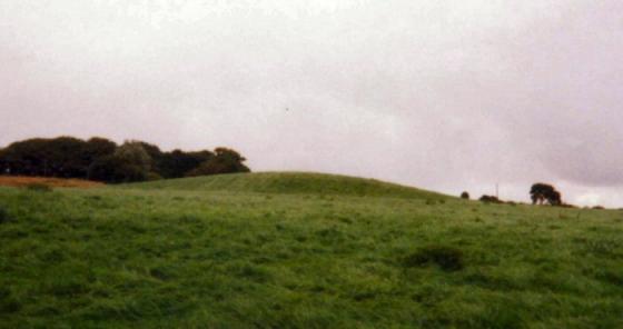
The depression at the top of this tumulus probably corresponds to a chamber at the base which has collapsed.
Image credit: www.davidaspinall.co.uk
The depression at the top of this tumulus probably corresponds to a chamber at the base which has collapsed.

An eroded section of Moor Top (Miners) Barrow I took a couple of years ago, looks like a slag heap to me.

curious carving on a stone inside the ‘cairn’ looks like an ‘M’ or a greek sigma

‘dug out’ centre of the ‘cairn‘
There is coal beneath this round barrow. It’s shown on the 1932 Geological Survey as the ‘Margery Band’ and it’s just a shallow seam. Trouble is that it’s thirty metres below ground level and that’s way beyond the depth of any bell pit. Other means of mining it would have left surface traces – which aren’t there – such as a road, a shed, a mineshaft etc. The stone that’s pictured on the barrow, with a carved ‘M’, is probably an ancient boundary stone – it was common to use tumuli as boundary markers – and the ‘M’ probably represents Margaret – Bolton’s patron saint.
I’m not so sure about the authenticity of this cairn there are three similliar mounds on the waterfalls walk at Anglezarke marked clearly as bellpits but theyre dug a little bit deeper and bigger than this one.