Images
Looking south.
The northern face of the Roman Stone. There are a couple of cupmarks about a third of the way down the shadowed side, to the left of the ridge running along the edge of the rock.
The cupmarked slab, bearing over 20 cupmarks.
Cupmarks on the southern face of the Roman Stone.
Looking north towards the foothills below Ben Chonzie and Carn Chois.
Looking northwest. The cupmarked slab is on the right.
These cup marks are a little eroded.
Clear cup marks on this end of the Stone.
The cup-marked rock.
Looking west along the group.
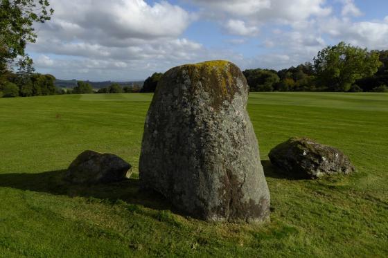
The Roman Stone plus two....
Articles
You cannot miss this one,it’s rather large. There are clear cup marks on pointy end and other eroded featuring on the face. There are other stones in the near area but I couldn’t find them. Maybe next time I’ll bring a strimmer.
Visited here today on a bitterly cold day. The Roman Stone – the big one, as Mr Brand mentions below – leans at an alarming angle over it’s smaller neighbours. The cup-marks on the flat stone are quite shallow, but very obvious nonetheless.
The name Roman Stone presumably comes from the fact that in the field nearby was a Roman camp.
Historic Scotland lists this as the remains of a stone circle, but as Fred Coles pointed out in 1911, there is a lack of any evidence to suggest that these stones ever formed part of a circle.
The main stone, a large block which leans markedly east, is the Roman Stone itself. Beside it is a small block, and six feet east a larger flat rock with over 20 cup-marks on its surface.
About a mile south of the bridge over the Earn at Comrie, on the moor of Dalginross, and on the left side of the road going to Glenartney and Braco, there is a well-known standing stone, popularly named after Samson.
It is one of a group of three. The other two are lying to the east, and on the upper side of the eastmost one, there are twenty-six cup marks.
From ‘Notes on Cup-Marked Stones, Old Burying -Grounds, and Curing or Charm Stone, near St. Fillans, Perthshire’ by J M Gow – Archaeological Review October 1888.
Directions – head west from Perth on the A85 for Crieff. Keep going straight into the centre of Crieff, and as you start to go down the steep hill, take the right turn (signposted A85 Lochearnhead, I think). Keep going on the A85 for about 7 miles and you will reach Comrie. In the centre of Comrie you will see a turn off to the left over the river, signposted “Wildlife Centre” amongst other things. Head down here to the bottom of the village, where you follow the road round a sharp right turn to leave the village. About 200m outside the village the Roman Stone is clearly visible by the road, on your left next to a sign for the footpath to Muirend.
View the site on the old OS map.
Sites within 20km of Wester Cowden Farm
-
Cultybraggan
photo 12 -
Dalginross
photo 27 description 5 link 1 -
Craggish
description 1 -
Tom na Chessaig
photo 4 description 2 link 1 -
Auchingarrich Farm
photo 17 description 4 link 2 -
Twenty Schilling Wood
photo 29 description 6 link 1 -
Lawers
photo 18 description 4 link 1 -
Glascorrie
photo 43 forum 2 description 8 link 2 -
Dunruchan
photo 81 description 4 -
Strowan Cairn
photo 2 description 1 -
Clathick House
-
Balmuick
photo 16 description 3 link 2 -
Druim Na Cille
photo 1 description 1 -
Kindrochet
photo 16 description 2 -
Carroglen
photo 9 description 1 -
Dalchirla
photo 13 -
Dalchirla
photo 11 description 2 -
Rottenreoch
photo 2 description 1 -
Dundurn
photo 14 forum 1 description 5 -
St Serf’s Water
description 1 -
Concraig
photo 7 description 1 -
Ochtertyre
description 1 -
Crieff
photo 6 description 2 -
Monzievaird
-
Duchlage
link 1 -
Bennybeg Cursus
description 1 link 1 -
Broich
description 1 -
Cairn Coinneachan
photo 21 description 4 -
Cradle Stone
photo 2 description 4 link 1 -
Dun Caoch
photo 8 description 1 link 1 -
Crieff Golf Course /
Ferntower photo 28 description 1 link 2 -
Witches Stone (Monzie)
photo 17 forum 1 description 7 link 2 -
Monzie Circle
photo 23 description 6 link 2 -
Monzie Rock Art
photo 19 description 1 link 4 -
Millhills
description 1 -
Glen Tarken
photo 7 description 2 link 2 -
Fingal’s Putting Stone
photo 3 description 1 -
Uamh Bheag
photo 5 description 2 link 1 -
Cultoquhey
photo 2 description 2 -
Connachan
photo 4 description 1 -
Milquhanzie Hill Fort
photo 4 -
Milquhanzie Hill
photo 3 -
Clach na Tiompan
photo 20 description 4 link 2 -
Clach na Tiompan
photo 1 description 1 link 1 -
Clach na Tiompan
photo 19 description 3 link 1 -
River Almond
photo 19 description 5 -
Bracklin Burn
photo 8 description 1 -
Buchanty Hill
photo 5 -
The Roundel
photo 4 description 1 link 1 -
Jock’s Cairn
photo 13 description 2 link 1 -
Fowlis Wester Standing Stones
photo 42 description 4 link 2 -
The Judge’s Cairn
photo 5 -
Fowlis Wester Cairn
photo 34 description 7 link 1 -
Braes of Fowlis
photo 44 description 4 link 1 -
Clach Ossian
photo 16 description 3 link 2 -
Buchanty Hill
photo 6 -
Giant's Grave (Sma' Glen)
photo 7 description 3 link 2 -
Giant’s Grave Cairn
photo 6 description 1 link 1 -
Ardveich
photo 11 description 1 -
The Camp Stone
description 1 -
The Boat Stone
photo 2 description 1 -
Dun Mor
photo 6 description 1 -
The Belted Stane
description 1 -
White Stone
photo 1 description 3 -
Stroness Hill
photo 3 -
Wester Biggs
description 1 -
Harper Stone
link 1 -
Tullich Hill
photo 2 description 1 -
Auchterarder
photo 29 description 7 link 3 -
Auchenlaich Cairn
photo 18 description 3 link 1 -
Gleneagles A
photo 9 description 1 -
Loaninghead
photo 10 forum 1 description 3 -
Gleneagles B
photo 16 description 1 -
The Gathering Stone
photo 1 description 3 -
Loch Freuchie
photo 5 description 1 -
Sheriffmuir Stone Row
photo 13 description 6 link 2 -
Corrymuckloch
photo 15 description 2 link 2 -
Wester Kinloch
photo 7 description 1 link 2 -
Glenhead Standing Stone
photo 6 description 4 -
Garrow
photo 3 description 1 -
The Auld Knowe
photo 3 description 2 -
Edinchip Chambered Cairn
photo 28 forum 1 description 5 link 2