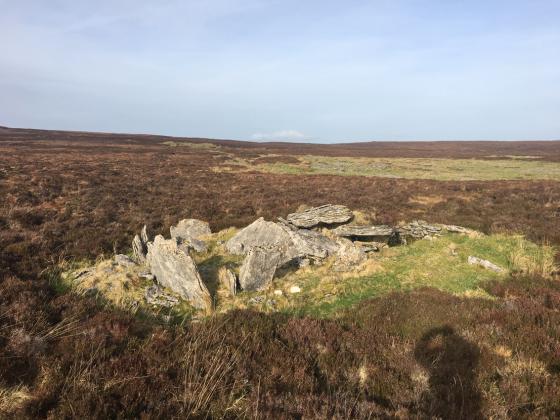
The Modern Antiquarian
Log in
|
Register
Home
Latest Posts
Forums
Maps
Help
Browse Sites
News
Blog
Contributors
The Books
Select
-
Belgium
Denmark
Eire
France
Germany
Greece
Italy
The Netherlands
Norway
Portugal
Republic of Malta
Spain
Sweden
Switzerland
United Kingdom
County Leitrim
Tawnymanus
Court Tomb
Tawnymanus (Court Tomb) on The Modern Antiquarian, the UK & Ireland's most popular megalithic community website. 5 images, plus information on many more ancient sites nearby and across the UK & Ireland.
Image © Charles Coughlan
Nearest Town:
Manorhamilton (3km N)
OS Ref (IE):
G882370 /
Sheets: 16, 26
Latitude:
54° 16' 53.65" N
Longitude:
8° 10' 52.27" W
Added by
FourWinds
Images (5)
1 discussion topic
Start a topic
Show |
Hide
Web searches for Tawnymanus
Flickr
Google
Google Images
The Megalithic Portal
Bing
Stone Pages
Wikipedia
Show map
(inline Google Map)
- Sites within 20 km -
-
Larkfield (0.01km ESE) (1 post)
Tullyskeherny (1.79km ENE) (7 posts)
Meenymore (3.07km E) (1 post)
Barracashlaun (5.72km WNW) (10 posts)
Carrigeengeare (6.11km ENE) (2 posts)
Gortnatresk (6.8km SSW) (1 post)
Lisdarush (9.37km NNE) (0 posts)
Largy (9.58km WNW) (5 posts)
Aghamore (10.87km WNW) (0 posts)
Aghamore (10.88km WNW) (10 posts)
Aghamore (10.94km WNW) (0 posts)
Aghamore (10.95km WNW) (0 posts)
Tawnamachugh (11.36km WNW) (0 posts)
Tawnamachugh (11.36km WNW) (7 posts)
Lisdrumgran (11.52km SE) (0 posts)
Killerry (12.27km WSW) (2 posts)
Cloonmeone Upper (12.46km SE) (5 posts)
Kilnagarns Lower (12.5km SE) (0 posts)
Kilnagarns Upper (12.5km SE) (0 posts)
Magheraghanrush (12.85km WSW) (30 posts)
Magheraghanrush Wedge Tomb (12.97km WSW) (4 posts)
Brockagh Lower (13.06km ENE) (2 posts)
Mautiagh (13.08km N) (7 posts)
Magheraghanrush Cashel (13.15km WSW) (3 posts)
Formoyle (13.33km W) (2 posts)
Shasgar (13.47km N) (0 posts)
Modorragh (13.75km SE) (0 posts)
Carrickbrannan (14.42km ESE) (5 posts)
Corracloona (16.72km NE) (12 posts)
Shesknan (16.97km WNW) (0 posts)
Carrownagh (17.18km WSW) (9 posts)
Arnasbrack (17.67km WSW) (4 posts)
Killinagh (17.76km ENE) (10 posts)
The Shannon Pot (17.84km E) (3 posts)
Druminalass (17.84km ESE) (1 post)
Moneygashel (17.9km E) (7 posts)
Moneygashel (17.98km E) (6 posts)
Knockatober (18km WSW) (6 posts)
Kilrooskagh (18.07km ENE) (5 posts)
Abbeyquarter North (18.18km WSW) (7 posts)
Drumgormly (18.35km NE) (0 posts)
Slieve Daeane (18.39km WSW) (2 posts)
Easky (18.41km SW) (2 posts)
Carrowcrin (18.88km WSW) (0 posts)
Slieve Dargan (18.89km WSW) (3 posts)
Mullaghboy (19km E) (3 posts)
Burren (SW) RA (19.18km E) (2 posts)
Burren (SW) (19.19km E) (9 posts)
Burren (Central, W) (19.2km E) (13 posts)
Slieve Dargan (19.21km WSW) (8 posts)
The Shaking Stone (19.22km ENE) (0 posts)
Burren (Central II) RA (19.3km E) (4 posts)
Burren (Central II) (19.3km E) (8 posts)
Burren (Central) (19.31km E) (12 posts)
Burren Central (III) (19.34km E) (3 posts)
Carrowroe (19.36km WSW) (1 post)
Dog Little (19.39km NE) (0 posts)
Rushin (19.44km ENE) (2 posts)
Cavancarragh (19.47km ENE) (5 posts)
The Rocking Stone (19.48km E) (1 post)
Garvagh (19.6km E) (4 posts)
Burren (N) (19.63km E) (2 posts)
Burren (E) (19.71km E) (24 posts)
Killy Beg Stone Circle (19.75km NE) (3 posts)
Ballydawley (19.8km WSW) (4 posts)
Killy Beg 4 (19.8km NNE) (0 posts)
Lanliss (19.84km E) (12 posts)
Killy Beg 3 (19.84km NNE) (0 posts)
Killy Beg 1 (19.85km NNE) (5 posts)
Killy Beg 2 (19.85km NNE) (3 posts)
Gourtnahoula/Ballaghnatrillick (19.9km WNW) (3 posts)
Manragh Upper (19.95km E) (1 post)
Garvagh (19.96km E) (0 posts)
- Add -
-
Add news
Add an image
Add fieldnotes
Add folklore
Add miscellaneous
Add a link
-
Add a site
Add a nearby facility
Add an alternative name/spelling
Images
(click to view fullsize)
Add an image