
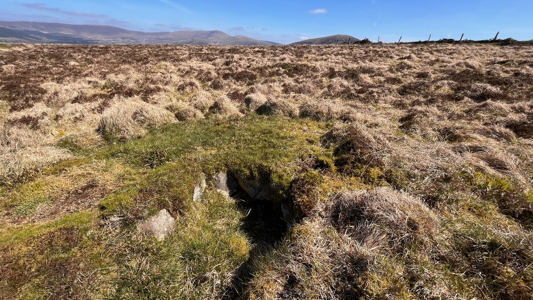
The most southerly of the six cairns, fully in Spinans Hill townland. The other five are in Ballyhubbock Upper.
Image credit: ryaner
The most southerly of the six cairns, fully in Spinans Hill townland. The other five are in Ballyhubbock Upper.

The modern wall crosses the cairn and delineates the townland boundary between Ballyhubbock Upper on the right and Spinans Hill on the left.

The stones in the right foreground could be remains of a subsidiary cist from the old cairn, or they could be the remains of a central chamber structure.

The cairn is badly wrecked.

Destroyed central cairn, said to be a passage tomb.

Another view of the central cist, or possibly even the chamber of a small passage tomb.
Central cist.

Kerbstones, or possible passage portal stones, at the easterly of the twin cairns.

Possibly the best preserved of the six cairns with kerbstones and a central cist.

Twin cairns in Ballyhubbock Upper townland, part of the Spinans Hill cairn cemetery.

Kerbstones just about visible.

Kerbstones visible on the northern side of of one of the cairns.

The most northerly of the six cairns looking north.

The most northerly of the six cairns.
The Spinans Hill Iron Age Hillfort complex comprises two hillforts; one on Spinans Hill itself and the other on Brusselstown Hill, both reputedly encompassed in a lower, massive fortification surrounding the two with a circumference of about 5 kilometres. This, if it exists, would cross 11 townlands. These are, clockwise from the north-west: Eadestown Hill, Ballyhubbock Lower, Ballyhubbock Upper, Castlesallagh, Coolamadra, Brusselstown, Castlequarter, Moorstown, Spinans Hill, Spinans East and Spinans Middle. The summit of Spinans Hill has a cairn cemetery with six cairns and is our target today.
I’ve explored this area quite a bit and always pronounced it as Spinans as in ‘spin’ but meeting a farmer whose land we had to pass through in Castlesallagh he pronounced it as Spynans, as in ‘spine’. The route up is not clear either. I’ve scouted around the west and south of the hill in the past and not found any easy way. Thank science for satellites; there is a track that begins at the 150m contour in Castlesallagh that traverses two fields owned by the aforementioned friendly farmer. It enters state forestry and is public access and brings you high up the hill before you must cross some heathland to gain the summit.
It’s a mostly gentle zigzag climb to the summit of Spinans at 410m over a distance of about 3 kilometres. Doesn’t sound like much but it’s the most strenuous jaunt I’ve done since falling ill last October. Slightly daunted but feeling good, the weather spurs us on – after what seems like 10 months of continuous rain, the sun breaks through and stays warm enough to have us shouldering our jackets. High up on the hill the the track runs out and we cross a steep bit of felled forestry. Then over a fence and onto some wild heathland and we’re almost there.
All the while the views have really opened up – the whole of the Glen of Imaal ranges behind us to the north-east, on over to Lugnaquilla, cloud-free today as it was when we climbed it last June. Keadeen broods over and dominates Brusselstown to our east. The forestry on the spur between the two hillforts doesn’t allow for us to track the massive encompassing fortification, but I think we encountered some of it on the east side on Spinans – low, ragged walling with some very large boulders snaking across the hillside for as far as the terrain allows us to see. Not long after we’re up into the cairnfield.
There are six cairns here, four in Ballyhubbock Upper townland; one, the largest, straddling the townland boundary of Ballyhubbock Upper and Spinans Hill; and the last, the most southerly, in Spinans Hill townland itself. None of which would have meant anything to the tomb builders, for that is what they are, tombs – a small prehistoric cairn cemetery. I get the notion that the trashed main mound, the one that straddles the ‘modern’ boundaries, was the first, and that the satellite tombs followed, possibly centuries after, who knows?
The level of destruction of the main tomb is almost total. There’s what may be the remains of a subsidiary chamber in its north-east quadrant, but any remains of a passage and chamber, for it is claimed to be a passage grave, are long gone. It is recognisable as a large cairn, but only just and is nearly flattened.
The small cairn to its south, in Spinans Hill townland, is being swallowed by the bog – the townland boundary demarcated by a fence crossing the main cairn looking like it separates two separately owned properties, the northern of which has been drained for grazing, the southern left to the wonders of sphagnum. The view across to Baltinglass Hill with its own megalithic wonders is gorgeous.
The northern four Ballyhubbock Upper cairns are all small, with only one showing a diminutive and distinct cist-like chamber at its centre. This has some possible kerbstones, as do two others. Three cairns are in a roughly north-south line, the fourth with the chamber to the east of the middle. They are all quite flat, but as with a lot of these upland cairns, the surrounding terrain has risen since they were first built and that, along with centuries of plundering, means they’re not much to look at, though they were obviously more distinct and proud of the surrounding terrain in the past.
The top of Spinans, with a long and fairly broad north-south expanse, reminded me of the top of Knocklayd (Cnoc Leithid – the hill of the slope or expanse) in Antrim. The ‘cemetery’ is closer to the southern end of this. It’s all said to be within Spinan’s own hillfort which in turn is encompassed in the massive fortifications along with Brusselstown, as mentioned earlier. I really felt that I was back in the game after this successful visit, having been defeated by access issues on more than one occasion in the past and having had doubts about whether I’d ever get back out there again.


