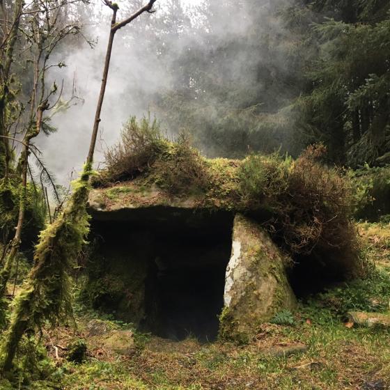
The Modern Antiquarian
Log in
|
Register
Home
Latest Posts
Forums
Maps
Help
Browse Sites
News
Blog
Contributors
The Books
Select
-
Belgium
Denmark
Eire
France
Germany
Greece
Italy
The Netherlands
Norway
Portugal
Republic of Malta
Spain
Sweden
Switzerland
United Kingdom
County Leitrim
Cleighran More
Court Tomb
Cleighran More (Court Tomb) on The Modern Antiquarian, the UK & Ireland's most popular megalithic community website. The site also contains a vast wealth of information on many more ancient sites across the UK & Ireland.
No image available
Nearest Town:
Drumshanbo (9km S)
OS Ref (IE):
G989195 /
Sheet: 26
Latitude:
54° 7' 28.13" N
Longitude:
8° 1' 0.57" W
Added by
ryaner
0 discussions
Start a topic
Show |
Hide
Web searches for Cleighran More
Flickr
Google
Google Images
The Megalithic Portal
Bing
Stone Pages
Wikipedia
Show map
(inline Google Map)
- Sites within 20 km -
-
Druminalass (3.45km N) (1 post)
Slieve Anierin (4.49km SE) (1 post)
Derryhallagh (7.56km S) (1 post)
Kilnagarns Lower (8.14km WNW) (0 posts)
Kilnagarns Upper (8.14km WNW) (0 posts)
Cloonmeone Upper (8.16km WNW) (5 posts)
Modorragh (8.22km W) (0 posts)
Carrickbrannan (9.04km N) (5 posts)
Kilronan Mountain (9.68km SW) (4 posts)
Cartronaglogh (9.95km SW) (5 posts)
Lisdrumgran (10.07km WNW) (0 posts)
Keadew East (11.26km SW) (0 posts)
Loughscur (11.92km SE) (4 posts)
Kilgarve (Boyle By.) (11.92km SW) (0 posts)
Knockranny (11.94km SW) (4 posts)
Loughscur (12.16km SE) (7 posts)
Drumany (12.56km ESE) (7 posts)
Drumany (12.73km ESE) (4 posts)
Churchfield (12.8km ESE) (0 posts)
Sheebeg (13.08km SE) (4 posts)
Edenmore (13.64km SSE) (0 posts)
The Shannon Pot (13.75km NNE) (3 posts)
Creevy (14.05km E) (3 posts)
Bridgecartron or Derrycashel (14.14km SW) (3 posts)
Creevy (14.24km E) (2 posts)
Bridgecartron or Derrycashel (14.42km SW) (4 posts)
Sheemore (14.68km SSE) (8 posts)
Creevy (14.8km ESE) (3 posts)
Garvagh (15.19km NE) (0 posts)
Mullaghboy (15.43km NE) (3 posts)
Kiltyhugh (15.59km E) (1 post)
Coolmurly (15.95km WSW) (3 posts)
Garvagh (15.97km NE) (4 posts)
Moneygashel (15.98km NNE) (7 posts)
Coolmurly (16.07km WSW) (0 posts)
Moneygashel (16.11km NNE) (6 posts)
Dromore (16.46km E) (1 post)
Knockmullin 3 (16.66km ESE) (0 posts)
Knockmullin 1 (16.66km ESE) (0 posts)
Treanmore (Tirerrill By.) (16.71km WSW) (3 posts)
Commons (16.71km ESE) (11 posts)
Fenagh (Glebe) (16.71km ESE) (1 post)
Fenagh Beg (16.72km ESE) (12 posts)
Fenagh Beg 3 (16.72km ESE) (2 posts)
Fenagh Beg 2 (16.72km ESE) (4 posts)
Fenagh Beg 4 (16.72km ESE) (1 post)
Knockmullin 2 (16.73km ESE) (0 posts)
Manragh Upper (17.08km NE) (1 post)
Burren (SW) (17.15km NNE) (9 posts)
Gortnatresk (17.22km WNW) (1 post)
Burren (SW) RA (17.24km NNE) (2 posts)
The Rocking Stone (17.3km NNE) (1 post)
Burren Central (III) (17.6km NNE) (3 posts)
Meenymore (17.73km NW) (1 post)
Kilnameel (17.77km NE) (0 posts)
Burren (Central) (17.86km NNE) (12 posts)
Manragh Upper (17.88km NE) (0 posts)
Burren (Central, W) (17.9km NNE) (13 posts)
Duckfield (17.9km NE) (4 posts)
Burren (Central II) (17.95km NNE) (8 posts)
Burren (Central II) RA (17.95km NNE) (4 posts)
Kilfaughna (17.98km SW) (3 posts)
Burren (E) (18.06km NNE) (24 posts)
Legalough (18.09km NE) (4 posts)
Legalough (18.09km NE) (2 posts)
Moytirra East (18.12km WSW) (4 posts)
Moytirra East (18.12km WSW) (13 posts)
Brockagh Lower (18.23km N) (2 posts)
Burren (N) (18.38km NNE) (2 posts)
Cootehall (18.45km SSW) (0 posts)
Lanliss (18.47km NNE) (12 posts)
Barroe North (18.95km WSW) (3 posts)
Cullentragh (19.06km NNE) (5 posts)
Tullyskeherny (19.59km NW) (7 posts)
Carrickglass (19.6km WSW) (22 posts)
Barroe Upper (19.6km WSW) (3 posts)
Killinagh (19.78km NNE) (10 posts)
Clyhannagh (19.81km NE) (12 posts)
- Add -
-
Add news
Add an image
Add fieldnotes
Add folklore
Add miscellaneous
Add a link
-
Add a site
Add a nearby facility
Add an alternative name/spelling