
A much more substantial cairn than I was expecting and a welcome stopping point on the way to Pressendye
A much more substantial cairn than I was expecting and a welcome stopping point on the way to Pressendye

All ready and waiting, however, no walkers today, not a soul all the way up and down.

Welcome resting place for the walkers with Pressendye in the background and the next stop.

Looking down on Pittenderich from Pressendye reveals its commanding position

From Blackhills.

From the north east.

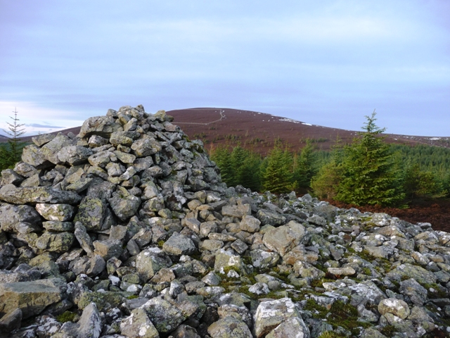
Some kind soul made us a bench.
On top of the cairn looking towards Pressendye.

From the east.

Meanwhile over in the west is Morven.

The north end looking north west.

The north end looking east.

The west end of Pittenderich with Pressendye posing in the background.

From the south west.
Heading North East from Tarland take the B9119, going past the Culsh souterrain, take the first minor road heading north after this show site. Les and I pulled in at the forestry track at the Hallhead Plantation. These tracks head eventually to top of Pressendye and we followed one of them as a path indicated on our maps had vanished, we assumed it was thanks to the new track we were on.
We kept going on through the Hallhead Plantation looking for a crossroads which never appeared. Pittenderich is to the south and we hoped this road would lead us to a clearing. It didn’t so we kept going a short distance until the road headed sharply north, we headed south cutting through the trees, jumped the fence and landed in a field just to the north of the ruined croft of Burnside.
The track at Burnside is a boggy mess but at least it led over the burn onto a track heading south up Pittenderich. Shortly after the track veers west a small track, today covered in snow, heads steeply upwards to the flat summit of Pittenderich.
There is a huge cairn on the summit. It sits at over 20m in diameter and is at least 3m high. As usual hill walkers have plonked their cairn on top. Four wind breaks (used as benches) have also been built into the cairn. All round this site are hills covered in prehistory – Pressendye, Morven, Mulloch, Cairn More etc etc – all with similarly large cairns. How this cairn isn’t listed anywhere is unbelievable. To me, it is one of the best Aberdeenshire cairns I’ve seen. (I’m sure Les was impressed also)
On the way down we retraced our steps to Burnside. This time we followed the tree line east as a track of sorts did exist. After field of heather a newish track appears which led us back to the new forestry road. The old track hadn’t vanished, they had simply built a new road next to the older which hid the original track round the side of forest from view.
It should be said that Thelonius encouraged me/us to have a look up here as did the Mad Man of Glass. So after a day of looking at nice wee cairns it was good to look at an absolute belter.
Update
Historic Scotland have been informed about this site. Aberdeenshire Archaeology are going to the survey the site. Also a track will lead to the summit of Pittenderich later this year.
Visited 29/12/2016.


