
Just below axe factory entrance. You get the feeling of slabs being removed / wedged away here. Unless it is just the geology.
Image credit: Chris Hughes - Chris Hill - JB
Just below axe factory entrance. You get the feeling of slabs being removed / wedged away here. Unless it is just the geology.

Upper rock face above the axe factory entrance – looks to be mined / carved. The striations look to be possibly man made. Marking lines almost?

View from Side Pike emphasising the extreme nature of the factory site towering above Mickleden (top right).
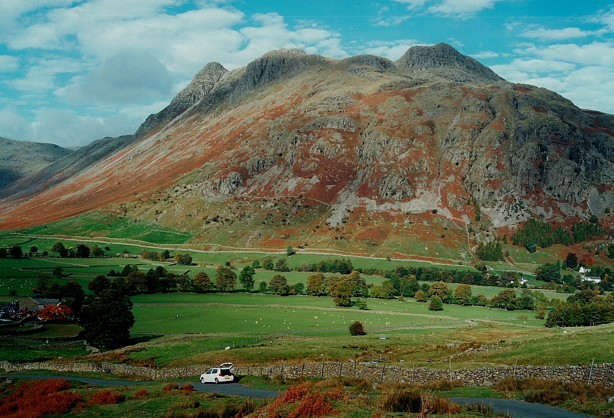
The iconic skyline from the Blea Tarn road...

Pike of Stickle from the east............

Langdale Tuff scraper found local to the axe factory; verified by several museums and others.

Pike of Stickle (left centre skyline) and Harrison Stickle (right) viewed from Wrynose Fell under somewhat dramatic lighting conditions. Note the scree sourced from the site....

12-10-2008
www.briankerrphotography.co.uk

01-04-06. Associations: Pike of Stickle from near the Glaramara stone axe factory.

The end of the voyage. Preferable to it being the start. The Pike of Stickle stone axe factory in all its glory.

Looking up the river of rocks that is the Pike of Stickle stone axe factory scree debris. Yes it is steep.

Looking up the Pike of Stickle stone axe factory scree debris.

Looking back up to the Pike of Stickle man-made cave.

Fissure in the Pike of Stickle man-made cave, showing evidence of stone chipping.

Looking to the back wall of the Pike of Stickle man-made cave.

Pike of Stickle man-made cave wall, showing evidence of the rock having been worked.

Small greenstone chippings and flakes on the floor of the Pike of Stickle man-made cave.

The Pike of Stickle man-made cave.
Width approx. 5 feet to 6 feet,
height approx 7 feet,
depth approx 7 feet.

Looking down on the Pike of Stickle man-made cave.

An edge worked onto the stone, found amongst the debris in the position shown, halfway down the Pike of Stickle scree.

At the side of the Pike of Stickle scree there are fewer rocks. Here I still found evidence of stone axe production, with flakes and chippings of the greenstone, amongst the other natural rock. Most of the scree is comprised of stone flakes and chippings.

Looking down the Pike of Stickle axe factory scree. Mickleden below. It’s as steep as it looks, but more unstable, like a waterfall of rocks.
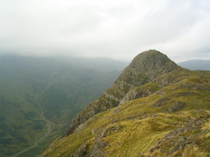
Pike of Stickle from Loft Crag, which also has an axe factory site. The Pike of Stickle axe factory scree is at the bottom of the rock face directly below the summit

Approaching Pike of Stickle from the NE. The entrance to the axe factory scree is in the col below the obvious steep wall on the left of the peak.

Some Great Langdale stone axe factory sites, viewed from Bow Fell (view from the W). Copt Howe in the distance.

Currently residing in Newcastle Upon Tyne Museum of Antiquities.
(The haft is a replica)

Currently residing in Newcastle Upon Tyne Museum of Antiquities

From Mickleden, looking up to the scree debris of the stone axe factory. Pike of Stickle on the left, the classic rock climbing area of Gimmer Crag on the right.

Screeeeeeeeeeeeeeee!
But no jumping allowed.

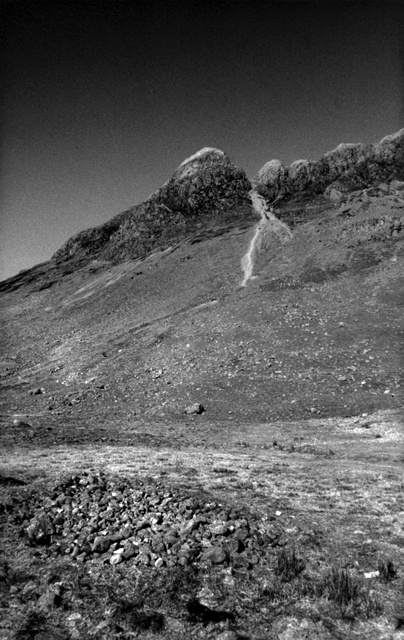
06/04. Cave on the Pike O’Sickle, viewed from across the scree gulley.

07/04. Pike Of Stickle, from Loft Crag. Great Gable beyond

07/04. Looking up the scree slopes to the axe factory and the Pike Of Stickle.

07/04. The Pike Of Stickle.

A map of the Mickleden section of Langdale valley, drawn mainly to be used to compare with the rock art at Copt Howe. This is a work in progress, as part of a planned larger project which may appear as a weblog essay in the near future.

The rocky dome of Pike O’Stickle protrudes from these high plains. Potential natural rock temples are scattered all over the environment. To call this just an axe factory, is in my mind, underestimating the powerful magic contained in this landscape. The axe-factory craftsmen would, most probably, have lived here for part of the year, and therefore most probably worshipped here.

The axe factory.

Pike O’Stickle from the head of Mickleden Beck.
Pike O’Stickle and the axe factory. In the foreground a pile of stones which look suspiciously like the remains of an ancient cairn, but could in fact hail from any period.

Pike O’Stickle from Martcrag Moor.

Beneath Pike O’Stickle.

The bizarre landscape just beneath Pike O’Stickle is made up of a series of small morainic hillocks.

Pike O’ Stickle looms above the scree slope of the axe factory.

The Axe Factory!

The view from Pike O’Stickle, looking over the Langdale Valley, Windermere and the North Pennines on the horizon.

Pike O’ Stickle.

A view of Pike O’ Stickle from Mickleden. The axe factory IS the scree slope!
03/10/09 The Siren Call.
Autumn truly arrived to the fell country on a day that saw me wandering alone amongst the Great Langdale stone axe factories. What lay in store should have been obvious when I was halted in my tracks by the wind, a fiendish rushing of air that nearly flattened me, raging down Mickleden, as if it was trying its best to pick up the ancient cairns dotted around and fling them as far as Ambleside. What followed next can only be described as taking an outdoor power shower. It was hard to see through the deluge, and, with the wind, it was painful to any exposed flesh. Well, the forecast had said to expect gusts of 85mph.
My main objective was an exploration of the Martcrag Moor site. At the head of Mickleden, by the old sheepfold, I headed up the Stake Pass track, the beck roaring down on my right. Some of it was roaring down anyway, with the exception of the waterfalls, which were being blown vertically upwards.
With some relief I managed to cross the beck at the top, and was soon on the top of Martcrag Moor, taking welcome shelter behind the rough grey rocks that mark the highest part. By now shafts of sunlight were stabbing into the valley from a tempestuous sky, storm-wracked and spectacular. Would the axe-makers have turned out in these conditions, I wondered.
Between Martcrag Moor and Pike of Stickle there is a flat col, known for its peaty, boggy ground. Erosion repair was under way, the workers absent, with sheep fleeces being laid as a base, before compressed gravel was laid on top, in order to prevent the repaired track from sinking. An ancient practice, apparently. It is around this spot that I had found flakes from axe production before, exposed where the peat had eroded away. They were there again, more being exposed by the increased erosion. There is a certain excitement for me in seeing the clean stone, as if it had been worked last week, with the purcushion marks clearly visible. The outer stone is a whiteish colour, but inside it is a wonderful blue-green. No doubt other evidence of working floors exists beneath the carpet of peat, but I can’t see any excavations taking place in the forseeable future. Despite a good search, I couldn’t find any other sites.
I went up onto Pike of Stickle, with the wind rushing up its precipitous slopes, before going down to the top of its huge axe factory scree. This is a very impressive place, with a humongous amount of stone. Pity most of it has headed valley way.
Not for me the precarious descent today. I was heading for the Thorn Crag site, taking in the Loft Crag site en-route. It was still a tad breezy, the difficulty not being finding the prehistoric evidence, but keeping on my feet. Loft Crag has stone chippings emerging from the peat on its eroded sections, but the peat is a much shallower deposit hereabouts. The clean chips are easy to spot, with very sharp edges. It’s hard to believe what your eyes see. Prehistoric “finds” are usually to be found in museums, not to be found at random on a days wanderings.
A couple of hundred yards away, over at the Thorn Crag site, I inspected the stony depressions that mark the quarry. Here again is evidence of stone-working, with flakes, and larger pieces, broken to expose the beautiful blue-green core, surrounded by a shell of white or terracotta. A lot of the debris lie over the edge, down in the upper reaches of the aptly named Dungeon Ghyll. As an aside, “Ghyll” is a Victorian affectation for the Norse word “Gill”. Both spellings can be found on maps of the area. I made a note to go down into the gill on another day, and take a look at the spoil.
I hadn’t met another soul, which was hardly surprising, as the saying goes that only mad dogs and TMA-ers go out in the morning storm. I finished the day with an ascent of Harrison Stickle, just for the view, as there were one or two sunny spells appearing, and the wind had reduced to a mere gale. Down by Stickle Tarn I went, where evidence of temporary occupation and working by the stone axe makers has been found, followed by a descent to the valley beside Mill Gill, a truly spectacular waterfall today, foaming white the whole length of its dash to the dale.
I had been a rewarding day, what with the battle with the elements, the stupendous mountain scenery, and last but not least by the site of something tangible from the past: a link with the industry of our Neolithic ancestors, the by-product of their labours.
The other day I decided to say sod it and go down the Pike of Stickle scree. We’re not really supposed to do it, and I’ll probably be criticised for it, but never mind. I trod carefully, at least as carefully as you can on sliding rocks.
The journey was part of a longer day on the hills, and I also visited the Thorn Crag and Loft Crag stone axe sites. I think all the Langdale stone axe sites should be split up into independant sites under the banner of “Langdale Axe Factory” on TMA. For instance, there’s sites over on Bow Fell.
Anyhow, all the sites had much evidence of stone flakes and chips. Lovely greenstone, once the surface has been removed. The Pike of Stickle scree held an amazing amount of this evidence. It has to be seen to be believed.
The man-made cave had lots of smaller stone chips – evidence of a certain amount of basic finishing of the axes, or of working of the cave? The cave was aproximately 5 to 6 feet wide, 7 feet deep, and 7 feet high.
The descent to the valley was interesting to say the least.
Years ago, as a young lad (aged about 8 in 1972), my dad took me down the Pike of Stickle scree run, and being used to steep places I revelled in it. The man-made cave was exciting to someone my age, and we explored inside. We also looked for axes, but found none. Further quick descents were made this way in the 70s, just to get off the mountains quickly.
In the late 80s onwards I used the scree run as a very fast descent from a days rock climbing – from the top, around 2,100 feet, to the bottom in less than ten minutes. It felt as fast as the speed of light when surfing down on a wave of stones. Little did we (or many others like us) think of the damage we were doing.
Now I resist the quick way, and hammer my knees on the steep tracks.
I will return soon to check out the cave again, but will take great care not to dislodge any stones – it will be the longest descent of the scree on record.
What a spectacular place.
It’s been about 10 years, so memory does not serve too well. To be totally honest I don’t think I was at the site of the factory, which isn’t surprising, as at the time I didn’t know it existed. But a couple of things stand out in my mind from wandering about the Langdale Pikes.
If you go the long way from the Old Dungeon Ghyll, up Mickleden Beck, following the Cumbrian Way, there’s a great long linear earthwork thing on the lefthand side, at the bottom of The Band, running up to Green Tongue. It looked a bit heavy duty for such an out of the way spot. No idea how old it might be.
At the very end of the valley, where Mickelden Beck splits to become Little Gill and Stake Gill (NY262074), there’s a sheepfold with a strange lobed footprint. It has a couple of little rooms added to the side. I couldn’t help but wonder if this was the remnants of a prehistoric house. It’s such a wonderfuly remote spot that the ground plan might just have survived, the walls having been re-built maybe hundreds of times after the roof fell in. Pure speculation, but in such a place, I couldn’t help but let me mind wander.
The ODG is an abso-effing-lootly great place to base yourself. Good food, good beer, decent rooms, a giant Jenga set, and even facilities for a small conference.
From The Old Dungeon Ghyll Hotel we headed along the Cumbrian Way that passes below the scree shoot and the Pike of Stickle. Then set off upwards towards the Pike calling in at the bulging bottom end of the shoot.
Then up through the bracken to the foot of the thimble shaped Pike of Stickle. We took the wide sloping grassy ledge that heads west and upwards before traversing eastwards to the quarried rocky ledges directly above the gulley of the main axe factory site. It’s a bit of a hairy route and you can end up feeling pretty exposed on some of the eastern ledges. But it gives you an impression of what it might’ve been like working up here.
After copping for some of the best views in the Lakes on top of the Stickle (Ingleborough is visible on the southern horizon on a good day); we headed off to Loft Crag before descending its buttress to pick up the path below Gimmer Crags. The smaller scree shoots here also contained many chippings and cast offs from axe production.
Much like Graig Llwydd in North Wales where the axe factory scarred the mountain with a deep notch. The workings here appear to have separated the Pike of Stickle from the rest of the Langdale Crags.
All in all a chuffin’ top place....
You’re quite right Mr I, I’m sure it would be very ill-advised to clamber about on the scree slope – and of course utterly illegal to remove anything archaeological you found there. But it’s very nice to be in such a quiet, spectacular and seemingly remote place and know that people were there so long ago making such important things. Well worth a visit to the valley and a pint in the pub afterwards.
The walk to the Langdale Axe factory is pretty difficult in comparison with a lot of neolithic sites. The site is directly below a mountain top, the summit is literally five minutes from the factory. The site is pretty much a scree slope. With a bit of time to spare and a lot of patience it may be possible to find evidence but be warned – the scree slope is very badly eroded and is currently out of bounds to all walkers and climbers. Using the slope is tempting but for the good of this stunning landscape is best left alone. It is best to be content with viewing the site from a distance and taking in the wonderful Langdale scenery. The Old Dungeon Ghyll pub should definitely form part of a visit to Langdale.
Rhiannon – I’ve got to say my visit was on a very nice day! ;-)
The day started beautifully, and we climbed up to the nearby waterfalls behind the pub. How picturesque (but rather clinical with all the beautifully laid steps). Then it started raining. To begin with quite half-heartedly, so we thought ‘We WILL see the axe factory’ as it was something I’d really looked forward to. It’s a beautiful closed valley, you just keep walking and walking and soon you’ve left the road behind, and it’s just you and these towering peaks. You can keep going over the top, out across the lake district. We did not. I have never seen so much rain in my life. We were so inadequately dressed, with a couple of light anoraks and two woefully battered umbrellas. People in scuba equipment would have stared at us as though we were mad. We battled on. The rain ran down our faces. I felt like a prune. We were determined to see it. Was this it? Was that it? Would we ever know? But when you get there, you know. The stones just look Right. We picked one up, it looked like a blank for an axe*. We practically swam back to the pub. But it was worth it. Later at the bizarre and unmissable Keswick museum we saw a finished axe – same stone. Fantastic. These axes were traded for hundreds of miles. Go on a nice day.
*It probably wasn’t. We weren’t high enough up the slope. And I know you’re not allowed to go nicking such things. But it was nice to have a bit of the same stone.
Regarding the rain, I’ve since read the following in a book of Lake District folklore: “How can you stand all this rain?” – “No sa weel. but we’re thinking on getting a lid for t’dale.”
Hence the phrase “We’ll have to borrow Langden lid.” Apparently.


