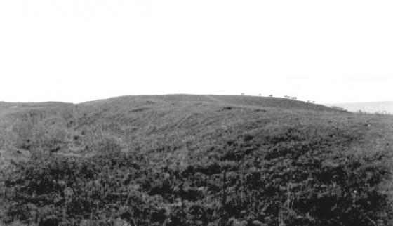
The Modern Antiquarian
Log in
|
Register
Home
Latest Posts
Forums
Maps
Help
Browse Sites
News
Blog
Contributors
The Books
Select
-
Belgium
Denmark
Eire
France
Germany
Greece
Italy
The Netherlands
Norway
Portugal
Republic of Malta
Spain
Sweden
Switzerland
United Kingdom
England
Southern England
Cornwall
Ligger Point
Round Barrow(s)
Ligger Point (Round Barrow(s)) on The Modern Antiquarian, the UK & Ireland's most popular megalithic community website. 8 images, plus information on many more ancient sites nearby and across the UK & Ireland.
Image © A. Brookes (19.6.2013)
Nearest Town:
Newquay (6km NE)
OS Ref (GB):
SW758581 /
Sheet: 200
Latitude:
50° 22' 45.68" N
Longitude:
5° 9' 13.81" W
Added by
thesweetcheat
Images (8)
0 discussions
Start a topic
Show |
Hide
Web searches for Ligger Point
Flickr
Google
Google Images
MAGIC
The Megalithic Portal
Bing
Stone Pages
Streetmap.co.uk
Wikipedia
Show map
(inline Google Map)
- Sites within 20 km -
-
Penhale Point Cliff Castle (1km NNW) (14 posts)
Holywell (1.56km NNE) (4 posts)
The Kelseys (2.21km NNE) (9 posts)
Cubert Common Burrow (2.63km ENE) (10 posts)
Kelsey Head Cliff Castle (2.79km N) (12 posts)
Cubert Stone (2.82km E) (5 posts)
Cubert Round (3.85km E) (5 posts)
Piran's Round (4.16km ESE) (15 posts)
Pentire Point East (4.18km NNE) (13 posts)
Gannel Rock Markings (4.44km NE) (8 posts)
Rosehill Farm (4.91km ESE) (1 post)
Tregingey Round (5.71km ENE) (5 posts)
Caer Keif (6.12km SE) (3 posts)
Caer Dane (6.22km SE) (6 posts)
Barrowfields (7.41km NE) (19 posts)
Callestick (7.67km SSE) (1 post)
Trevelgue Head (8.28km NE) (20 posts)
St. Agnes Beacon (9.14km SSW) (28 posts)
Tresawsen (9.16km SE) (1 post)
Pendown (9.28km SSE) (1 post)
Whipsiderry (9.39km NE) (17 posts)
Callestick Vean (9.45km SSE) (1 post)
Carland Cross Burrows (9.63km E) (3 posts)
Tubby's Head (9.66km SW) (8 posts)
Four Burrows (9.8km SSE) (6 posts)
Mitchell Farm (10.09km E) (1 post)
Allet (10.25km SE) (1 post)
Hendra Farm (10.92km E) (1 post)
Three Burrows (11.08km S) (2 posts)
Melancoose Round (11.16km ENE) (2 posts)
Two Burrows (11.35km S) (1 post)
Little Regarded Farm (11.68km SSE) (1 post)
Bishop's Wood (Truro) (11.75km ESE) (3 posts)
Griffin's Point (11.78km NE) (9 posts)
High Cove (13.56km NE) (4 posts)
Redcliff Castle (14.57km NE) (9 posts)
St. Eval Airfield Stone (14.98km NE) (14 posts)
Trevisker Round (15.1km NE) (4 posts)
Park Head fort (15.17km NNE) (7 posts)
Treburrick Menhir (15.59km NE) (5 posts)
Park Head cemetery (15.75km NNE) (17 posts)
St. Eval Church Stones (15.87km NE) (14 posts)
Nance (16.09km SW) (2 posts)
Devil's Quoit (16.87km ENE) (11 posts)
Porthcothan Fogou (16.96km NE) (2 posts)
Cregou Barrow (17.29km ESE) (2 posts)
Rowan Cove (17.33km NNE) (4 posts)
Pennatillie (17.83km NE) (1 post)
Fox Cove (18.03km NNE) (4 posts)
The Long Stone (18.15km NE) (14 posts)
Winecove Point (18.18km NNE) (13 posts)
Bogee Barrow B (18.34km NE) (4 posts)
Tehidy Round (18.36km SW) (6 posts)
Bogee Barrow A (18.36km NE) (2 posts)
Higher Trevibban (18.38km NE) (1 post)
Deep Tye Farm (18.61km ENE) (1 post)
Prince Parc (18.67km ENE) (1 post)
Crane Castle (18.74km SW) (17 posts)
Bogee Farm (18.78km NE) (1 post)
Carvossa Enclosure (18.79km E) (2 posts)
Carn Brea (18.92km SSW) (33 posts)
Castle-an-Dinas (St. Columb) (19.12km ENE) (35 posts)
St Dennis (19.23km ENE) (8 posts)
Round Wood (19.35km SE) (2 posts)
Trebowland Round (19.59km S) (2 posts)
Constantine Church stone (19.62km NNE) (10 posts)
Carvannel Menhir (19.91km S) (6 posts)
Golden Hillfort (19.96km E) (4 posts)
- Facilities within 20 km -
-
Perranporth Youth Hostel (Youth Hostel: 3.9 km S)
Gull Rock (Holiday Cottage: 3.9 km S)
Newquay Youth Hostel (Youth Hostel: 7.2 km NE)
Travel Inn (Motor Lodge: 14.7 km E)
Royal Cornwall Museum (Museum: 14.8 km SE)
Treyarnon Bay (Youth Hostel: 18.9 km NNE)
- Add -
-
Add news
Add an image
Add fieldnotes
Add folklore
Add miscellaneous
Add a link
Add a nearby facility
Add an alternative name/spelling
Images
(click to view fullsize)
Add an image