Skip to content
Julian Cope
presents
The Modern
Antiquarian
Latest
Posts
Sites
Map
Blog
Forum
search
Search
⚠️
Sign in
more_horiz
Eire
County Cork
Teernahillane
Standing Stone / Menhir
V638465
expand_more
Nearest town:
Sneem (21km N)
OS reference:
V638465
OS sheet:
84
Latitude:
51° 39' 16.68 N
Longitude:
9° 58' 6.02 W
Added to TMA by
Meic
Images (4)
Add
content
Images
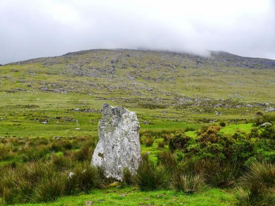
Image credit: Michael Mitchell
Meic
Mar 2, 2013
Image credit: Michael Mitchell
Meic
Mar 2, 2013
26th February 2013
Image credit: Michael Mitchell
Meic
Mar 2, 2013
26th February 2013
Image credit: Michael Mitchell
Meic
Mar 2, 2013
Sites within 20km of
Teernahillane
Teernahillane
Wedge Tomb
•
0.13km SSW
photo
9
Teernahillane
Dolmen / Quoit / Cromlech
•
0.73km SE
photo
1
Teernahillane
Stone Row / Alignment
•
0.73km SE
photo
3
Knockoura
Stone Row / Alignment
•
1.93km SSW
photo
1
description
1
Fanahy
Stone Row / Alignment
•
2.04km ESE
photo
4
Gour
Standing Stones
•
2.37km SSW
photo
9
description
1
Ardacluggin
Standing Stone / Menhir
•
2.68km WNW
photo
1
Derreenataggart West
Stone Circle
•
2.69km ENE
photo
26
forum
2
description
5
Coulagh
Stone Circle
•
2.82km NW
photo
5
Coulagh
Standing Stone / Menhir
•
3km NNW
photo
1
Ardacluggin
Standing Stone / Menhir
•
3.29km WNW
photo
4
Derreenataggart Middle
Standing Stone / Menhir
•
3.44km E
photo
2
Urhin
Standing Stone / Menhir
•
3.68km W
photo
5
Kealoge
Standing Stones
•
3.87km SW
photo
3
Kealoge
Standing Stone / Menhir
•
4.57km W
photo
6
Kilmackowen
Standing Stone / Menhir
•
5.15km NE
photo
9
Kilmackowen
Wedge Tomb
•
5.17km NE
photo
16
description
1
Derrymihin West
Dolmen / Quoit / Cromlech
•
5.28km ENE
photo
3
Rodeen 3
Standing Stone / Menhir
•
5.89km ENE
photo
4
Cloontreem
Wedge Tomb
•
6.07km ENE
photo
13
description
2
Rodeen 2
Standing Stone / Menhir
•
6.12km ENE
photo
5
Rodeen 1
Standing Stone / Menhir
•
6.12km ENE
photo
3
Cahermore
Standing Stone / Menhir
•
6.42km SW
photo
4
description
1
Ballycrovane
Standing Stone / Menhir
•
6.67km NNE
photo
16
description
2
Hag of Beara
Natural Rock Feature
•
6.69km NNW
photo
5
description
4
Killough West
Wedge Tomb
•
8.21km SW
photo
8
description
1
Loughane More
Stone Fort / Dun
•
10.89km SW
photo
6
Ardgroom Outward
Stone Circle
•
11.16km NE
photo
31
description
3
Glashananinnaun
Stone Circle
•
12.84km NE
photo
5
Shronebirrane
Stone Circle
•
14.58km NE
photo
19
description
3
Coomgira
Standing Stone / Menhir
•
14.61km ENE
photo
6
Gort na Gainimhe
Standing Stones
•
15.16km WSW
photo
5
description
1
Cashelkeelty NW
Stone Circle
•
15.52km NE
photo
10
description
2
Cashelkeelty SE
Stone Circle
•
15.66km NE
photo
12
description
1
Caherdaniel
Stone Fort / Dun
•
15.76km WNW
photo
3
description
1
Staigue Bridge
Cup and Ring Marks / Rock Art
•
15.76km NNW
photo
10
description
2
link
1
Staigue
Standing Stone / Menhir
•
15.86km NNW
Darrynane More
Standing Stone / Menhir
•
16.08km WNW
photo
7
description
1
Coomnahorna East
Standing Stones
•
16.44km NW
The Waters
Standing Stone / Menhir
•
16.9km WSW
photo
1
description
2
Staigue Cashel
Stone Fort / Dun
•
16.99km NNW
photo
21
Reenkilla
Stone Circle
•
17.11km NE
photo
4
description
1
Caherurlagh
Standing Stone / Menhir
•
17.24km ESE
photo
6
Clogherane
Stone Row / Alignment
•
17.37km ENE
photo
3
Clogherane
Standing Stone / Menhir
•
17.4km ENE
photo
3
Cahernageeha
Burial Chamber
•
17.56km WNW
photo
4
description
1
Peakeen
Passage Grave
•
18.23km E
photo
6
Cappaleigh North
Standing Stone / Menhir
•
18.76km ENE
photo
3
description
1
Drumlave
Stone Row / Alignment
•
18.81km ENE
photo
10
description
1
Kilcaskan
Stone Row / Alignment
•
18.84km ENE
photo
4
description
1
Coomatloukane North
Wedge Tomb
•
18.85km WNW
photo
11
Coomatloukane
Wedge Tomb
•
18.91km WNW
photo
16
Kildromalive
Standing Stone / Menhir
•
19.26km ENE
photo
4
description
1
Lehid
Wedge Tomb
•
19.82km NE
photo
2
Loher
Stone Fort / Dun
•
19.93km WNW
photo
13
ondemand_video
1
description
1
search
I’m looking for…
location_on
photo
ondemand_video
forum
description
link