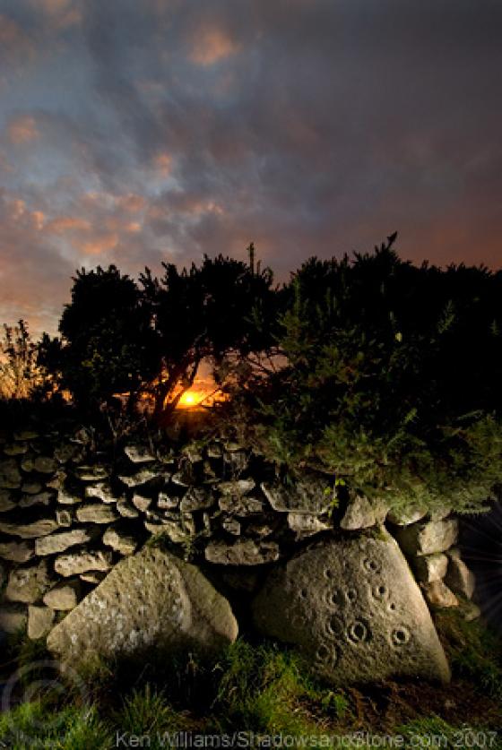
The Modern Antiquarian
Log in
|
Register
Home
Latest Posts
Forums
Maps
Help
Browse Sites
News
Blog
Contributors
The Books
Select
-
Belgium
Denmark
Eire
France
Germany
Greece
Italy
The Netherlands
Norway
Portugal
Republic of Malta
Spain
Sweden
Switzerland
United Kingdom
County Carlow
Crannagh
Cup and Ring Marks / Rock Art
Crannagh (Cup and Ring Marks / Rock Art) on The Modern Antiquarian, the UK & Ireland's most popular megalithic community website. 3 images, plus information on many more ancient sites nearby and across the UK & Ireland.
Image © Ken Williams/ShadowsandStone.com 2007
Nearest Town:
Borris (9km WSW)
OS Ref (IE):
S816512 /
Sheet: 68
Latitude:
52° 36' 21.68" N
Longitude:
6° 47' 43.34" W
Added by
CianMcLiam
Images (3)
0 discussions
Start a topic
Show |
Hide
Web searches for Crannagh
Flickr
Google
Google Images
The Megalithic Portal
Bing
Stone Pages
Wikipedia
Show map
(inline Google Map)
- Sites within 20 km -
-
Crannagh (1.3km W) (0 posts)
Knockroe (1.74km SE) (9 posts)
Knockroe (3.29km SE) (6 posts)
The Nine Stones (3.4km N) (4 posts)
Mount Leinster (3.7km NNW) (5 posts)
Slievebawn (3.73km NW) (5 posts)
Knockmore (4.04km WSW) (2 posts)
Rathgeran (4.08km SSW) (4 posts)
Rathgeran (4.24km SW) (7 posts)
Kilmissan (4.31km SW) (0 posts)
Rathgeran Hill (4.39km SW) (8 posts)
Knockscur (4.46km W) (0 posts)
Rathgeran Upper (4.6km SSW) (3 posts)
Killoughternane (4.69km W) (0 posts)
Killoughternane/Knockscur (4.69km W) (4 posts)
Kilmissan (4.85km SW) (0 posts)
Coolasnaghta (5.4km NNW) (2 posts)
Kyle (5.7km WSW) (0 posts)
Spahill (5.92km W) (2 posts)
Rossard (7.12km ENE) (0 posts)
Tinncarrig (7.14km SW) (5 posts)
Ballinasilloge (7.16km W) (11 posts)
Myshall (8.83km N) (3 posts)
Gowlin (8.93km SSW) (0 posts)
Newtown (9.45km SW) (2 posts)
Ullard (9.61km WSW) (5 posts)
Ballinkillin (10.04km W) (3 posts)
Toberbride (10.08km NW) (0 posts)
Knockbrack Cairns (10.39km NNE) (0 posts)
Knockbrack (10.46km NNE) (2 posts)
Ballinkillin (10.52km W) (0 posts)
Knockbarragh (10.95km NNE) (0 posts)
Aghnaglear (11.14km SSW) (3 posts)
Tomdarrach (11.7km W) (2 posts)
Kilgraney (12.04km W) (11 posts)
Ballyellin and Tomdarragh (12.06km W) (3 posts)
Kilcruit (12.13km W) (2 posts)
Carriglead (12.27km SW) (0 posts)
Brandon Hill (13.19km WSW) (2 posts)
Dranagh Cairn(s) (13.36km SSW) (2 posts)
Sragh (13.66km NNE) (0 posts)
Kildreenagh (13.66km NW) (5 posts)
Clonegall (13.75km NE) (0 posts)
Kildreenagh 2 (13.76km NW) (2 posts)
Dranagh (13.85km SSW) (2 posts)
Dranagh (13.95km SSW) (2 posts)
Dranagh Standing Stone 2 (14.15km SSW) (4 posts)
Curraghacruit (14.57km WNW) (0 posts)
Fenniscourt (14.77km W) (7 posts)
Dunleckny (15.08km WNW) (1 post)
Kilmurray (15.17km N) (0 posts)
St Mullin's Well (15.66km SW) (2 posts)
Dranagh (now in St. Mullins) (15.78km SW) (6 posts)
Brandon Hill (16.17km SW) (0 posts)
Curraun (16.64km SSW) (2 posts)
Huntsman's Cross Road (17.04km NNW) (0 posts)
Ballinvarry Irish (17.17km SW) (1 post)
Coolroe (17.39km NNE) (3 posts)
Aghade (17.47km N) (4 posts)
Craans (17.48km NNE) (6 posts)
Rathwade (17.48km WNW) (0 posts)
Ardattin (17.55km NNE) (3 posts)
Blacklion (18.34km NNE) (0 posts)
Ballynoe (18.39km N) (1 post)
Scarawalsh (18.5km E) (0 posts)
Killabeg (18.5km E) (2 posts)
Ballynavortha (18.5km NNE) (2 posts)
Cloch An Phoill (Aghade) (18.52km N) (9 posts)
Killabeg Tumulus (18.59km E) (2 posts)
Leighlinbridge (18.69km WNW) (5 posts)
Knockbower (18.89km NW) (0 posts)
Cullaun (18.89km SW) (0 posts)
Moylisha (19.9km NE) (8 posts)
- Add -
-
Add news
Add an image
Add fieldnotes
Add folklore
Add miscellaneous
Add a link
-
Add a site
Add a nearby facility
Add an alternative name/spelling
Images
(click to view fullsize)
Add an image