The Modern Antiquarian
Log in
|
Register
Home
Latest Posts
Forums
Maps
Help
Browse Sites
News
Blog
Contributors
The Books
Select
-
Belgium
Denmark
Eire
France
Germany
Greece
Italy
The Netherlands
Norway
Portugal
Republic of Malta
Spain
Sweden
Switzerland
United Kingdom
County Waterford
Tooreen
Tooreen Row
Stone Row / Alignment
Tooreen Row (Stone Row / Alignment) on The Modern Antiquarian, the UK & Ireland's most popular megalithic community website. 1 image, 1 fieldnote, plus information on many more ancient sites nearby and across the UK & Ireland.
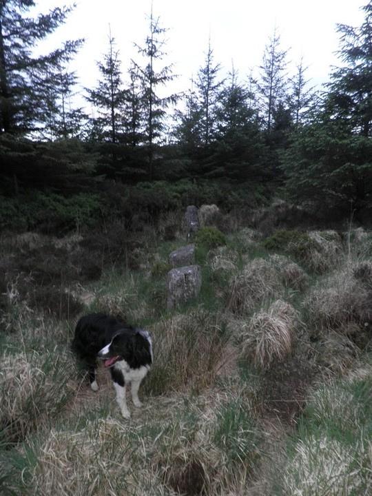
Image © Bawn79 © 2011
Nearest Town:
Clonmel (12km NW)
OS Ref (IE):
S247118 /
Sheet: 75
Latitude:
52° 15' 26.97" N
Longitude:
7° 38' 17.65" W
Added by
FourWinds
Images (1)
Fieldnotes (1)
0 discussions
Start a topic
Show |
Hide
Web searches for Tooreen Row
Flickr
Google
Google Images
The Megalithic Portal
Bing
Stone Pages
Wikipedia
Show map
(inline Google Map)
- Sites within 20 km -
-
Tooreen Circle (0.22km E) (4 posts)
Tooreen Barrow (W) (0.36km SW) (0 posts)
Tooreen Barrow (E) (0.72km ESE) (0 posts)
Knockanaffrin (3.32km NE) (4 posts)
Carrigeen (3.5km ENE) (2 posts)
Curraghaskin (3.67km SW) (0 posts)
Monavullagh North Cairn (5.13km SE) (0 posts)
Monavullagh Central Cairn (5.63km SE) (0 posts)
Poul-na-maddra-ruadh (5.67km SE) (3 posts)
Togher (6.3km NW) (5 posts)
Poul-na-maddra-ruadh (6.3km SE) (3 posts)
Monavullagh South Cairn (6.44km SE) (0 posts)
Scartnadriny (6.64km SSE) (0 posts)
Monavullagh Standing Stone (7.14km SE) (4 posts)
Knockboy (7.16km SSW) (0 posts)
Coumeraglinmountain NE (7.33km SE) (0 posts)
Coumeraglinmountain North Barrow (7.41km SSE) (0 posts)
Coumeraglinmountain Standing Stone (N) (7.93km SSE) (0 posts)
Coumeraglinmountain Standing Stone (S) (8.03km SSE) (0 posts)
Coumeraglinmountain Cairns (8.36km SSE) (0 posts)
Graigavalla (8.36km ENE) (0 posts)
Coumeraglinmountain SW (8.41km SSE) (0 posts)
Coumeraglinmountain South Barrow (8.5km SSE) (0 posts)
Cloghadda (8.85km N) (0 posts)
Coumeraglinmountain Megalithic Tomb (unclassified) (8.89km S) (8 posts)
Curraghkeily (9.04km NE) (0 posts)
Treenearla Commons (10.12km SE) (3 posts)
Treenearla Commons (10.22km SE) (3 posts)
Treenearla Commons (10.27km SSE) (5 posts)
Bohadoon Mountain (10.94km SSE) (4 posts)
Parkbeg (11km NE) (0 posts)
Bawnard (11.3km N) (0 posts)
Gurteen Lower (11.3km N) (0 posts)
Coolnahorna (12.07km ENE) (0 posts)
Kealfoun (13.11km E) (0 posts)
Croughaun Hill (13.27km E) (0 posts)
Carrigmoorna (13.62km SE) (2 posts)
Rathmaiden (13.78km E) (0 posts)
Sheskin (15.15km ENE) (0 posts)
Clogh Leabhrais (15.17km ESE) (1 post)
Glenaphuca (15.26km ENE) (0 posts)
Jamestown (15.43km N) (3 posts)
Temple-etney (15.43km N) (1 post)
Giantsgrave (15.5km NW) (4 posts)
Mothel Stone (15.6km ENE) (5 posts)
Drumlohan (15.83km ESE) (12 posts)
Glennafallia (15.84km WSW) (5 posts)
Ballypatrick (16.72km NNE) (3 posts)
Ballyquin (17.53km ENE) (2 posts)
Ballyquin (17.56km ENE) (10 posts)
Whitestown (17.84km ENE) (0 posts)
Mullaghnoney (18.21km WNW) (4 posts)
Sheshkin (near Stradbally) (18.27km ESE) (4 posts)
Ballyvoyle (18.35km ESE) (1 post)
Ballyhussa (18.56km E) (0 posts)
Ballyquin (18.65km ENE) (4 posts)
Slievenamon (19.55km NNE) (7 posts)
The Birr Stone (19.7km WSW) (4 posts)
- Add -
-
Add news
Add an image
Add fieldnotes
Add folklore
Add miscellaneous
Add a link
-
Add a site
Add a nearby facility
Add an alternative name/spelling
Images
(click to view fullsize)
Add an image
Fieldnotes
Add fieldnotes
A small (in height) stone row of redish sandstone (I think). It may be that some of the height is lost in the bog below. It is signposted from the nearby stone circle.
Comments (0)
|
Add a comment
|
Permalink
Posted by
bawn79
10th December 2011ce