The Modern Antiquarian
Log in
|
Register
Home
Latest Posts
Forums
Maps
Help
Browse Sites
News
Blog
Contributors
The Books
Select
-
Belgium
Denmark
Eire
France
Germany
Greece
Italy
The Netherlands
Norway
Portugal
Republic of Malta
Spain
Sweden
Switzerland
United Kingdom
County Carlow
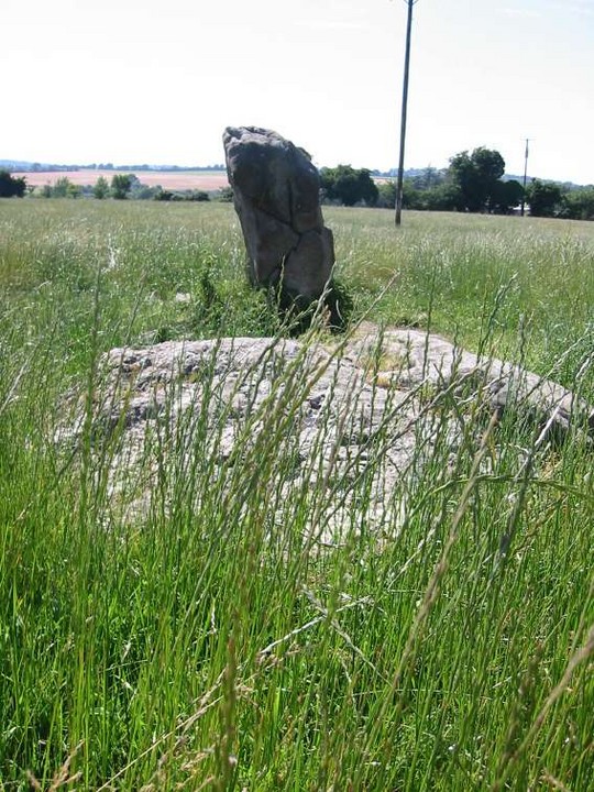
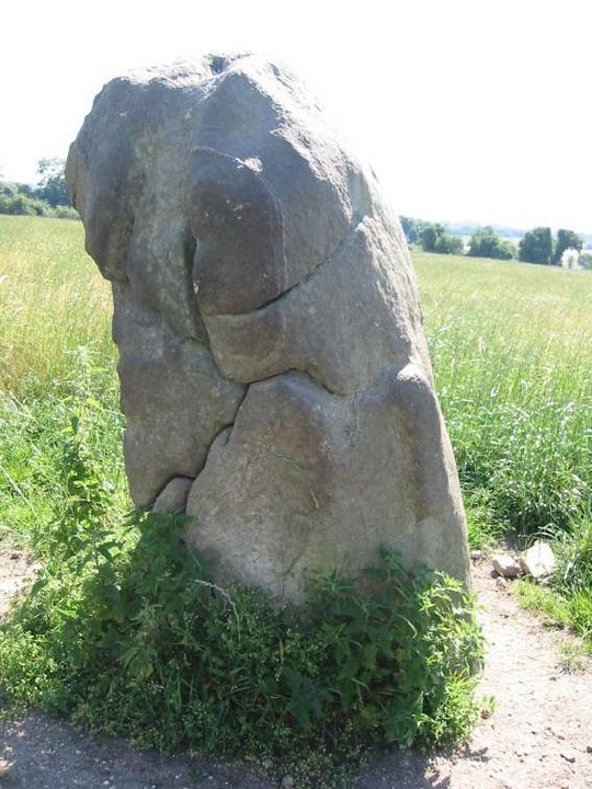
Tombeagh
Standing Stone / Menhir
Tombeagh (The Giant's Lift) (Standing Stone / Menhir) on The Modern Antiquarian, the UK & Ireland's most popular megalithic community website. 2 images, plus information on many more ancient sites nearby and across the UK & Ireland.
Image © ryaner
Also known as:
The Giant's Lift
Nearest Town:
Hacketstown (4km E)
OS Ref (IE):
S935814 /
Sheet: 62
Latitude:
52° 52' 31.54" N
Longitude:
6° 36' 40.14" W
Added by
FourWinds
Images (2)
0 discussions
Start a topic
Show |
Hide
Web searches for Tombeagh
Flickr
Google
Google Images
The Megalithic Portal
Bing
Stone Pages
Wikipedia
Show map
(inline Google Map)
- Sites within 20 km -
-
Williamstown (2.71km SW) (7 posts)
Humewood Castle (4.3km N) (4 posts)
Patrickswell (4.85km W) (0 posts)
Haroldstown (4.87km SW) (38 posts)
Knockballystine (5.92km SW) (0 posts)
Clonmore (5.98km SE) (3 posts)
Tobinstown (6.42km SW) (0 posts)
Carrig Mountain (7.23km NNE) (0 posts)
Muckduff Upper 2/Carrig Mountain (7.32km NNE) (4 posts)
Colvinstown Upper II (7.46km NNW) (2 posts)
Colvinstown Upper (7.57km NNW) (4 posts)
Colvinstown (7.59km NNW) (3 posts)
Colvinstown Upper III (7.6km NNW) (2 posts)
Kilmagarvoge (7.66km WSW) (1 post)
Keadeen standing stone 2 (7.7km NNE) (2 posts)
Muckduff Upper (7.87km NNE) (5 posts)
Boleycarrigeen (7.89km N) (57 posts)
Kilranelagh (7.95km NNW) (0 posts)
Keadeen (8.24km N) (0 posts)
Keadeen (8.25km N) (3 posts)
Keadeen (8.34km N) (3 posts)
Rathmore (8.35km WSW) (0 posts)
Kilranelagh Graveyard (8.44km NW) (6 posts)
Keadeen Cursus (8.58km N) (5 posts)
Keadeen Mountain (8.67km N) (4 posts)
Rath East (8.72km SSW) (0 posts)
Seskin (8.81km SE) (0 posts)
Rath Gael (8.82km SSW) (17 posts)
Rathcoran Hillfort (9.24km WNW) (3 posts)
Baltinglass Hill - Tombs (9.24km WNW) (19 posts)
Baltinglass Hill Cairn - Standing Stone (9.24km WNW) (2 posts)
Baltinglass Hill - Standing Stone (9.24km WNW) (1 post)
Baltinglass Hill - Cairn (9.24km WNW) (2 posts)
Baltinglass Hill (9.33km WNW) (2 posts)
Baltinglass Hill 'Basin' Stone (9.38km WNW) (3 posts)
Killabeg Stone (9.42km SSE) (0 posts)
Brusselstown Ring (9.6km NNW) (22 posts)
Spinans Hill (9.98km NNW) (0 posts)
Tuckmill Hill (10.05km WNW) (3 posts)
Spinans Hill (10.36km NNW) (14 posts)
Straboe (11.03km WSW) (0 posts)
Eadestown North (11.4km NNW) (0 posts)
Lybagh (11.42km NE) (0 posts)
Coan (11.66km NNE) (0 posts)
Aghowle Lower (11.98km S) (3 posts)
Hughstown (11.99km WNW) (4 posts)
Tinoran Hill (12.22km WNW) (0 posts)
The Ballintruer Long Stone (12.25km NW) (0 posts)
Ballintruer More (12.25km NW) (6 posts)
Rathglass (12.4km SW) (0 posts)
Castleruddery (13.02km NNW) (48 posts)
Aghowle Upper (13.12km SSE) (5 posts)
Castleruddery Lower (13.18km NNW) (4 posts)
Kelshamore (13.38km N) (5 posts)
Leitrim (13.65km NNE) (7 posts)
Ardristan 2 (13.69km SW) (0 posts)
Ardristan (13.69km SW) (11 posts)
Moylisha (13.88km S) (8 posts)
Brittas III (14.18km NNE) (4 posts)
Brittas V (14.18km NNE) (3 posts)
Brittas (14.18km NNE) (7 posts)
Brittas IV (14.18km NNE) (7 posts)
Brittas II (14.18km NNE) (2 posts)
Blacklion (14.19km SSW) (0 posts)
Knickeen (14.3km NNE) (9 posts)
Ballynavortha (14.33km S) (2 posts)
Ballynoe (14.56km SW) (1 post)
Cloch An Phoill (Aghade) (14.82km SW) (9 posts)
Ardattin (14.88km SSW) (3 posts)
Craans (14.92km SSW) (6 posts)
Preban (15.08km E) (10 posts)
Coolroe (15.41km S) (3 posts)
Glenoge (15.42km WSW) (2 posts)
Aghade (15.42km SW) (4 posts)
Killenora (15.91km WSW) (0 posts)
Donard (16.28km NNW) (6 posts)
Busherstown (16.71km WSW) (0 posts)
Bennekerry (16.77km WSW) (0 posts)
Kilcoagh East/Levern (17.07km N) (1 post)
Kilcoagh East (17.11km N) (3 posts)
Broomfields (17.17km NNW) (12 posts)
Kilbaylet Lower (17.37km N) (5 posts)
Kilbaylet Lower (17.47km N) (5 posts)
Bolton Hill (17.52km W) (7 posts)
Kilmurray (17.88km SW) (0 posts)
Blackmoor (17.95km NNW) (6 posts)
Fananierin (18.46km ENE) (5 posts)
Sragh (18.97km SSW) (0 posts)
Kilbaylet Upper (19.27km N) (4 posts)
Tornant Upper (19.42km NW) (8 posts)
Browne's Hill (19.47km WSW) (38 posts)
Killeen Cormac (19.66km NW) (4 posts)
Church Mountain (19.82km N) (4 posts)
Tornant Lower (19.86km NW) (2 posts)
- Add -
-
Add news
Add an image
Add fieldnotes
Add folklore
Add miscellaneous
Add a link
-
Add a site
Add a nearby facility
Add an alternative name/spelling
Images
(click to view fullsize)
Add an image
 Image © ryaner