The Modern Antiquarian
Log in
|
Register
Home
Latest Posts
Forums
Maps
Help
Browse Sites
News
Blog
Contributors
The Books
Select
-
Belgium
Denmark
Eire
France
Germany
Greece
Italy
The Netherlands
Norway
Portugal
Republic of Malta
Spain
Sweden
Switzerland
United Kingdom
Wales
Ceredigion
Gilfach-Hafel Camp
Hillfort
Gilfach-Hafel Camp (Gaer) (Hillfort) on The Modern Antiquarian, the UK & Ireland's most popular megalithic community website. 1 image, plus information on many more ancient sites nearby and across the UK & Ireland.
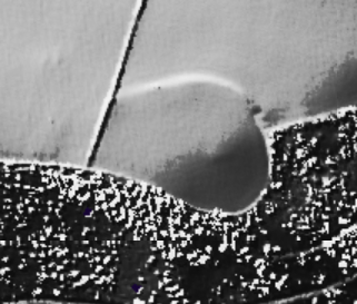
Image © LiDAR Composite Dataset. Contains public sector information licensed under the Open Government Licence v2.0.
Also known as:
Gaer
Nearest Town:
Aberystwyth (12km N)
OS Ref (GB):
SN559700 /
Sheet: 135
Latitude:
52° 18' 31.4" N
Longitude:
4° 6' 50.15" W
Added by
Kammer
Images (1)
0 discussions
Start a topic
Show |
Hide
Web searches for Gilfach-Hafel Camp
Flickr
Google
Google Images
The Megalithic Portal
Bing
Stone Pages
Streetmap.co.uk
Wikipedia
Show map
(inline Google Map)
- Sites within 20 km -
-
Caer Penrhos (0.86km SW) (4 posts)
Castell Bach and Castell Mawr (2.55km WSW) (15 posts)
Pen Glog (3.45km NNW) (7 posts)
Llech Bron (5.43km SSW) (5 posts)
Garn Wen, Mynydd Bach (North) (6.29km E) (13 posts)
Tan-yr-Esgair, Mynydd Bach (South) (6.41km E) (7 posts)
Ffynnon Drewi (Mynydd Bach) (6.51km E) (2 posts)
Gaer Fawr, Trawsgoed (9.14km ENE) (11 posts)
Old Warren Hillfort (10.33km NNE) (13 posts)
Trichrug (10.33km S) (11 posts)
Pendinas (Aberystwyth) (10.49km N) (49 posts)
Fan (Nantcwnlle) (11.3km SSE) (10 posts)
Y Garreg Fawr (11.63km NNE) (10 posts)
Castell Flemish (11.64km E) (13 posts)
Castell Disgwylfa (13.3km ENE) (9 posts)
Cnwc y Bugail (13.4km ENE) (9 posts)
Capel Bangor Camp (14.6km NE) (3 posts)
Craig Ysradmeurig (14.68km E) (8 posts)
Pen-y-Felin Wynt (14.71km NE) (4 posts)
Carreg Llwyd (West) (15km NNE) (4 posts)
Pen-y-Ffrwyd Llwyd Camp (15.02km E) (14 posts)
Carreg Llwyd (East) (15.05km NNE) (5 posts)
Banc-y-Geufron (15.68km ENE) (8 posts)
Fron Ddu (15.9km ENE) (3 posts)
Castell Tregaron. Sunnyhill wood camp (16.08km ESE) (13 posts)
Hen Gaer (16.16km NNE) (2 posts)
Pen-y-Graig (Llanarth) (16.19km SW) (3 posts)
Castle Grogwynion (16.33km ENE) (12 posts)
Penrhyn-Coch War Memorial (16.33km NNE) (4 posts)
Tan-y-Ffordd (16.52km NE) (12 posts)
Bwlch-y-Crwys (16.85km ENE) (1 post)
Penrhyncoch Camp (17.14km NE) (5 posts)
Gelli Round Barrow (17.65km NE) (7 posts)
Banc y Darren (17.65km NE) (6 posts)
Darren Camp (17.67km NE) (12 posts)
Ffynnon-Wen (Llangybi) (17.76km SE) (1 post)
Castell Bwa-Drain (18.04km ENE) (12 posts)
Carreg Samson (Llethr) (18.19km ENE) (3 posts)
Llwyn-on-Fach (18.2km SW) (10 posts)
Bryngwyn Bach (18.34km E) (20 posts)
Pen-y-Bannau (18.49km E) (25 posts)
Cerrig yr Wyn (18.57km NE) (21 posts)
Banc-y-Gwyngoed (18.58km ESE) (10 posts)
Garn Wen (Trefeurig) (18.96km NE) (10 posts)
Esgair Nant-yr-Arian (18.99km NE) (11 posts)
Garn Felen (Llanddewi Brefi) (19.23km ESE) (0 posts)
Bryn Rhudd (19.28km ESE) (22 posts)
Tanybryn-Isaf (Trefeurig) (19.3km NE) (5 posts)
Bryn-y-Crofftau (19.4km E) (12 posts)
Castell Moeddyn (19.47km SSW) (1 post)
Devil's Punch Bowl (19.51km ENE) (6 posts)
Groes Fawr (19.59km E) (6 posts)
Y Garn (Garn Gron) (19.61km E) (11 posts)
Garn Fawr (Tregaron) (19.61km ESE) (10 posts)
Bryn Rhudd (19.63km ESE) (1 post)
Carn Dolgau (19.63km NE) (9 posts)
Pen-y-Castell Hillfort (19.66km NE) (24 posts)
Garrig Hir (19.76km NE) (13 posts)
Penmaen-Gwyn (19.84km E) (5 posts)
Pen-y-Castell Stone (19.86km NE) (5 posts)
Carreg Samson (19.88km ESE) (1 post)
Bryn Rhosau (19.96km ENE) (11 posts)
Castell Rhyfel (19.99km E) (13 posts)
- Facilities within 20 km -
-
Brynarian Caravan Park (Camping Site: 5.9 km S)
Black Lion (Pub: 11.6 km N)
Gogerddan Arms Hotel (Pub: 11.6 km N)
Yr Hen Orsaf (Weathers... (Pub: 11.8 km N)
Penguin Cafe (Cafe: 11.8 km N)
The National Monuments... (Library: 11.9 km N)
Treehouse Organic Food... (Restaurant: 11.9 km N)
Aberystwyth Tourist In... (Tourist Information: 12 km N)
Scholars (Pub: 12.1 km N)
Harry's Hotel & Restau... (Restaurant: 12.1 km N)
The National Library o... (Library: 12.1 km N)
Farmers Arms (Pub: 12.1 km NE)
Halfway Inn (Pub: 12.1 km NE)
Aberaeron Tourist Info... (Tourist Information: 12.5 km SW)
Maesbangor Arms (Pub: 14.2 km NNE)
Druid Inn (Pub: 17.1 km NE)
Hafod Arms Hotel (Hotel: 19.4 km ENE)
New Quay Tourist Infor... (Tourist Information: 19.9 km SW)
- Add -
-
Add news
Add an image
Add fieldnotes
Add folklore
Add miscellaneous
Add a link
-
Add a site
Add a nearby facility
Add an alternative name/spelling
Images
(click to view fullsize)
Add an image