The Modern Antiquarian
Log in
|
Register
Home
Latest Posts
Forums
Maps
Help
Browse Sites
News
Blog
Contributors
The Books
Select
-
Belgium
Denmark
Eire
France
Germany
Greece
Italy
The Netherlands
Norway
Portugal
Republic of Malta
Spain
Sweden
Switzerland
United Kingdom
Scotland
Perth and Kinross
Grey Stane
Standing Stone / Menhir
Grey Stane (Clashbenny) (Standing Stone / Menhir) on The Modern Antiquarian, the UK & Ireland's most popular megalithic community website. 4 images, 1 fieldnote, plus information on many more ancient sites nearby and across the UK & Ireland.
Image © nickbrand
Also known as:
Clashbenny
Nearest Town:
Newburgh (3km SSE)
OS Ref (GB):
NO222213 /
Sheets: 53, 58
Latitude:
56° 22' 39.12" N
Longitude:
3° 15' 35.67" W
Added by
nickbrand
Images (4)
Fieldnotes (1)
0 discussions
Start a topic
Show |
Hide
Web searches for Grey Stane
Flickr
Google
Google Images
MAGIC
The Megalithic Portal
Bing
Stone Pages
Streetmap.co.uk
Wikipedia
Show map
(inline Google Map)
- Sites within 20 km -
-
Hawk Stane (1.69km WSW) (8 posts)
St Madoes Stone Row (2.51km WSW) (7 posts)
Inchyra (3.25km WSW) (9 posts)
Over Durdie (3.83km NW) (11 posts)
Clatchchard Craig (4.1km ESE) (3 posts)
Black Cairn (4.31km SE) (12 posts)
Macduff's Cross (4.62km SSE) (9 posts)
Evelick (4.97km NW) (12 posts)
Goddens (5.17km NW) (6 posts)
Pole Hill (5.42km WNW) (8 posts)
Rait (5.5km N) (10 posts)
Rait Farm (5.52km N) (4 posts)
Fingask (5.83km N) (12 posts)
Kilspindie (5.84km W) (3 posts)
Kilspindie (5.84km W) (17 posts)
Kilspindie (5.84km W) (11 posts)
Beal Hill (6.13km NW) (5 posts)
Abernethy Den (6.19km SW) (10 posts)
Glenduckie (6.3km E) (11 posts)
Arnbathie (6.89km WNW) (6 posts)
Law Hill (6.9km WNW) (8 posts)
Murrayshall Hill (7km W) (2 posts)
Law Hill (7.06km WNW) (9 posts)
Castle Law (Abernethy) (7.14km SW) (13 posts)
Shien Hill (7.22km WNW) (9 posts)
Deuchny Wood (7.35km W) (5 posts)
Inchmartine (7.39km NE) (5 posts)
Norman's Law (8.34km E) (15 posts)
Bonhard (8.5km W) (15 posts)
Moredun Top (8.65km WSW) (2 posts)
Moncrieffe (8.8km WSW) (4 posts)
Moncrieffe House (8.8km WSW) (8 posts)
Shianbank (8.96km WNW) (13 posts)
Moncreiffe Hill (9.15km WSW) (1 post)
Bandirran Circle East (9.65km NNW) (20 posts)
Creich Manse (9.67km E) (20 posts)
Bandirran Circle West (9.77km NNW) (30 posts)
Murrary Royal Standing Stone (9.9km W) (3 posts)
Bandirran 4-poster (9.96km NNW) (4 posts)
Collessie Farm (9.99km ESE) (10 posts)
Green Craig (10.06km ENE) (11 posts)
Craigclowan (10.17km WSW) (4 posts)
The Long Man's Grave (10.18km NNW) (12 posts)
Sandy Road Scone (10.31km W) (8 posts)
Dunsinnan Hill (10.32km NNW) (12 posts)
Collessie (10.74km ESE) (3 posts)
Balmalcolm (10.99km NNW) (4 posts)
Hilton Of Moncrieffe (11.08km WSW) (3 posts)
Little Dunsinane (11.22km NNW) (5 posts)
Dove Craig (11.32km WNW) (4 posts)
Brownies Knowe (11.35km WNW) (8 posts)
St.Martins (11.51km WNW) (4 posts)
St Martins (11.65km WNW) (7 posts)
King's Seat (11.73km N) (4 posts)
Falcon Stone (12.03km NE) (11 posts)
Witch's Stone (12.05km WNW) (6 posts)
Dron Hill (12.07km WSW) (4 posts)
Green Hill (12.28km ENE) (9 posts)
Callarfountain (12.37km WSW) (3 posts)
Williamston (12.49km WNW) (9 posts)
Easter Nether Urquhart (12.5km S) (5 posts)
Blairhall (12.5km W) (1 post)
Ardgilzean Cottage (12.57km WNW) (10 posts)
Carmichael Cottages Cursus (12.61km NE) (1 post)
Dron Hill (12.68km NE) (21 posts)
Williamston (12.87km WNW) (2 posts)
Market Knowe (12.91km NE) (10 posts)
Blackfaulds Stone Circle (13.01km WNW) (19 posts)
Coultra Hill (13.1km ENE) (6 posts)
Gallowstone (13.1km ENE) (1 post)
Macbeth's Law (13.33km NNW) (4 posts)
Castle Law (Forgandenny) (13.51km WSW) (4 posts)
Craigmakerran (13.61km WNW) (2 posts)
Wolfhill (13.64km WNW) (8 posts)
Druids Seat Stone Circle (13.89km WNW) (29 posts)
Battle Law (14.04km ENE) (4 posts)
Denmarkfield / King's Stone (14.23km W) (9 posts)
Maiden Castle (Lomonds) (14.4km SSE) (14 posts)
Perth Western Edge (14.45km W) (5 posts)
Denmarkfield Farm (14.59km W) (2 posts)
East Whitefield (14.62km NW) (2 posts)
Colen Wood Stone Circle (14.83km WNW) (18 posts)
West Lomond Hill (14.85km S) (19 posts)
Hill Of Dores (15.17km N) (13 posts)
East Lomond (15.23km SSE) (9 posts)
East Lomond (15.23km SSE) (19 posts)
Abbots Deuglie (15.25km SW) (1 post)
Newbigging (15.4km NW) (5 posts)
Gallow Hill Wood (15.63km NW) (5 posts)
Huntingtower (15.66km W) (1 post)
Devil's Stone (Invergowrie) (15.7km NE) (9 posts)
West Blair (15.8km SW) (5 posts)
Hurly Hawkins (15.87km NE) (4 posts)
Pitlandie (16.01km W) (6 posts)
Purin (16.09km SE) (6 posts)
Pitcur Souterrain (16.37km N) (15 posts)
Balgarthno (16.55km NE) (33 posts)
Overbenchil Farm (16.69km WNW) (9 posts)
Balholmie (16.69km NW) (9 posts)
Dark Stane Roundie (16.98km ENE) (5 posts)
Gellybank Stone Row (17.15km W) (11 posts)
Lady Mary's Wood (17.21km ESE) (12 posts)
Camperdown Park (17.38km NE) (4 posts)
Bowden Hill (17.42km ESE) (3 posts)
Forteviot (17.5km WSW) (7 posts)
Camperdown (17.6km NE) (7 posts)
Moneydie (17.88km W) (18 posts)
Black Laws (18.07km E) (6 posts)
Balgay Hill (18.12km ENE) (2 posts)
Orwell (18.47km SSW) (16 posts)
Loak (18.58km WNW) (7 posts)
Down Law (18.59km ESE) (13 posts)
Loak (18.72km WNW) (7 posts)
West Mains (18.77km NNE) (7 posts)
Balfarg (19.09km SE) (43 posts)
Balfarg Riding School (19.12km SE) (15 posts)
High Keillor Farm (19.16km NNE) (20 posts)
Dronley House (19.19km NE) (7 posts)
Pitcairn (19.3km SE) (8 posts)
non rock art (19.3km ENE) (32 posts)
Balbirnie (19.41km SE) (50 posts)
Camp Wood (19.42km ENE) (17 posts)
Dundee Law (19.58km ENE) (16 posts)
Newton Of Balbirnie (19.71km SE) (5 posts)
Cleaven Dyke (19.72km NW) (16 posts)
Lyndoch East Stone (19.76km W) (4 posts)
Strathendry (19.78km SSE) (11 posts)
Knowehead (19.79km NNW) (9 posts)
- Facilities within 20 km -
-
The Famous Bein Inn (Pub: 10.1 km SSW)
Glenfarg Hotel (Hotel: 13.8 km SSW)
Tayside Hotel (Hotel: 16.5 km NW)
Ballathie House Hotel (Hotel: 17.8 km NW)
Drouthy Neebors (Pub: 19.2 km NE)
Laing's Bar (Pub: 19.3 km NE)
Meikleour Hotel (Pub: 19.6 km NNW)
Tonic (Pub: 19.7 km NE)
The Phoenix (Pub: 19.8 km NE)
- Add -
-
Add news
Add an image
Add fieldnotes
Add folklore
Add miscellaneous
Add a link
-
Add a site
Add a nearby facility
Add an alternative name/spelling
Images
(click to view fullsize)
Add an image
Fieldnotes
Add fieldnotes
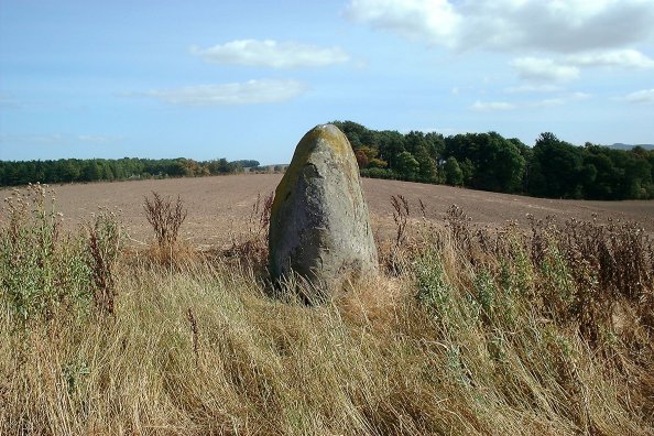
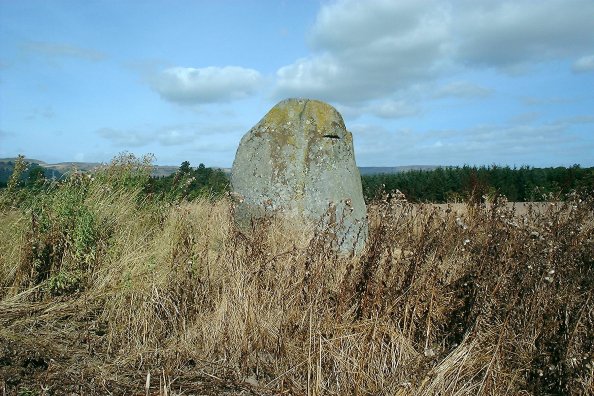
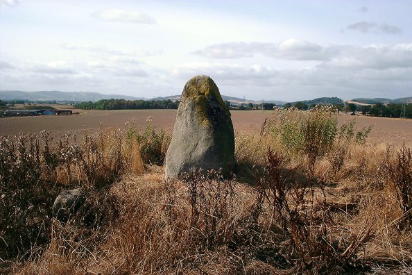
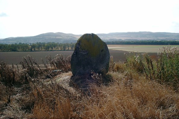
I've driven past this many times, and the field was always in crop. Today it wasn't, so here it is. A simple, unadorned, 2m+ tall stone, known locally as the Grey Stane.
Comments (0)
|
Add a comment
|
Permalink
Posted by
nickbrand
12th September 2003ce

 Posted by nickbrand