The Modern Antiquarian
Log in
|
Register
Home
Latest Posts
Forums
Maps
Help
Browse Sites
News
Blog
Contributors
The Books
Select
-
Belgium
Denmark
Eire
France
Germany
Greece
Italy
The Netherlands
Norway
Portugal
Republic of Malta
Spain
Sweden
Switzerland
United Kingdom
County Waterford
Powersknock
Standing Stone / Menhir
Powersknock (Standing Stone / Menhir) on The Modern Antiquarian, the UK & Ireland's most popular megalithic community website. 1 image, plus information on many more ancient sites nearby and across the UK & Ireland.
Image © Alan S>
Nearest Town:
Tramore (9km SE)
OS Ref (IE):
S522084 /
Sheets: 75, 76
Latitude:
52° 13' 30.06" N
Longitude:
7° 14' 9.66" W
Added by
FourWinds
Images (1)
0 discussions
Start a topic
Show |
Hide
Web searches for Powersknock
Flickr
Google
Google Images
The Megalithic Portal
Bing
Stone Pages
Wikipedia
Show map
(inline Google Map)
- Sites within 20 km -
-
The Sweep (0km N) (0 posts)
Raheens (1.58km SW) (0 posts)
Whitfield (1.8km E) (2 posts)
Gaulstown (2.76km ESE) (24 posts)
Gaulstown Cist (2.76km ESE) (1 post)
Ballymote (3.76km SE) (7 posts)
Ballymote Barrow (3.76km SE) (1 post)
Crough (4.97km SSW) (0 posts)
Ballynaclogh South (5.12km ESE) (2 posts)
Matthewstown (5.54km SSE) (9 posts)
Knockeen (5.61km E) (12 posts)
Ballynageeragh (5.94km SSW) (19 posts)
Lisduggan (5.94km E) (0 posts)
Lissahane (6.36km WSW) (0 posts)
Dunhill (6.42km SSW) (12 posts)
Savagetown (7.15km SW) (0 posts)
Carrickavrantry (7.16km SE) (4 posts)
Knockanduff (7.2km SE) (0 posts)
Savagetown (7.59km SW) (4 posts)
Castlecraddock (7.59km SW) (0 posts)
Carriglong (7.67km E) (7 posts)
Couse (7.98km ENE) (0 posts)
Pickardstown (8.16km E) (0 posts)
Kilbarrymeaden (8.84km SW) (5 posts)
Ballyhussa (9.17km WSW) (0 posts)
Woodstown (9.96km S) (2 posts)
Whitestown (11.07km W) (0 posts)
Glenaphuca (12.82km W) (0 posts)
Blenheim Hill (13.2km ENE) (0 posts)
Ballygunnertemple (13.2km ENE) (2 posts)
Rathmaiden (13.88km W) (0 posts)
Croughaun Hill (14.38km W) (0 posts)
Ballyquin (14.39km WNW) (4 posts)
Ballyquin (14.49km WNW) (2 posts)
Ballyquin (14.56km WNW) (10 posts)
Mothel Stone (14.74km W) (5 posts)
Kealfoun (14.96km WSW) (0 posts)
Davidstown (15.39km NE) (4 posts)
Faithlegg (15.61km ENE) (3 posts)
Coolnahorna (15.85km W) (0 posts)
Harristown (15.86km E) (12 posts)
Farnoge (16.04km NNE) (2 posts)
Leckaun (16.49km E) (0 posts)
Drumlohan (17.08km WSW) (12 posts)
Ballyhenebery (17.63km NW) (5 posts)
Sheskin (18.67km WNW) (0 posts)
Rochestown (18.9km NE) (0 posts)
Whitechurch (19.07km WNW) (5 posts)
Ballyvaheen Tomb (19.55km NNE) (0 posts)
Garryduff (19.65km NW) (4 posts)
Owning (19.67km NW) (4 posts)
Kilmogue Standing Stone (19.77km NNW) (1 post)
Kilmogue (19.86km NNW) (35 posts)
Ballyvaheen (19.91km NNE) (2 posts)
- Add -
-
Add news
Add an image
Add fieldnotes
Add folklore
Add miscellaneous
Add a link
-
Add a site
Add a nearby facility
Add an alternative name/spelling
Images
(click to view fullsize)
Add an image
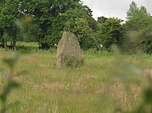 Image © Alan S>

