The Modern Antiquarian
Log in
|
Register
Home
Latest Posts
Forums
Maps
Help
Browse Sites
News
Blog
Contributors
The Books
Select
-
Belgium
Denmark
Eire
France
Germany
Greece
Italy
The Netherlands
Norway
Portugal
Republic of Malta
Spain
Sweden
Switzerland
United Kingdom
Scotland
Central Scotland
City of Edinburgh
Blackford Hill fort
Hillfort
Blackford Hill fort (Hillfort) on The Modern Antiquarian, the UK & Ireland's most popular megalithic community website. 2 images, plus information on many more ancient sites nearby and across the UK & Ireland.
Image © thelonious
Nearest Town:
Edinburgh (4km NNW)
OS Ref (GB):
NT25457064 /
Sheet: 66
Latitude:
55° 55' 22.91" N
Longitude:
3° 11' 35.18" W
Added by
thesweetcheat
Images (2)
0 discussions
Start a topic
Show |
Hide
Web searches for Blackford Hill fort
Flickr
Google
Google Images
MAGIC
The Megalithic Portal
Bing
Stone Pages
Streetmap.co.uk
Wikipedia
Show map
(inline Google Map)
- Sites within 20 km -
-
Blackford Hill (0.15km WSW) (25 posts)
Braid Hills (site of) (1.1km SSW) (2 posts)
The Bore Stane (1.28km WNW) (10 posts)
Penny Well (1.35km NE) (4 posts)
The Buck Stane (1.63km SW) (10 posts)
The Cat Stane, Inch (1.94km E) (6 posts)
Galachlaw Cairn (2.35km S) (11 posts)
The Caiy Stane (2.61km SSW) (16 posts)
Wells O' Wearie (2.61km NE) (5 posts)
Wester Craiglockhart Hill (2.68km WSW) (2 posts)
Samson's Ribs (2.71km NE) (8 posts)
Ravenswood Avenue Standing Stone (2.75km E) (6 posts)
Edinburgh Castle (2.87km NNW) (8 posts)
St. Catherine's Well (2.92km ESE) (6 posts)
Arthur's Seat and Crow Hill fort (3km NE) (13 posts)
St. Vining's Well (3.13km NNE) (1 post)
The Dasses (3.29km NE) (4 posts)
Cultivation Terraces (3.32km NE) (3 posts)
Duddingston Loch (3.39km ENE) (8 posts)
Delf Well (3.42km NE) (6 posts)
St. David's Well (3.46km NNE) (2 posts)
St. Margaret's Well (3.46km NNE) (12 posts)
St. Anthony's Well (3.59km NE) (4 posts)
Dunsapie (3.69km NE) (14 posts)
Niddrie Standing Stone (4.47km ENE) (6 posts)
Hillend (4.53km S) (19 posts)
St. Triduana's Wellhouse (4.7km NE) (8 posts)
Caerketton Hill (4.76km SSW) (12 posts)
Parkburn Cist Cemetery (5.49km E) (7 posts)
Corstorphine Hill (6.02km W) (21 posts)
Castlelaw Fort (7.07km SSW) (24 posts)
Castlelaw Souterrain (7.29km SSW) (21 posts)
Gorton House (7.82km SE) (16 posts)
Roslin Glen (7.94km SE) (6 posts)
St. Matthew's Well (7.95km SE) (3 posts)
Glencorse (8.07km S) (9 posts)
Cammo Stone (8.9km W) (11 posts)
Turnhouse Hill Cairn (9km SSW) (4 posts)
Turnhouse Hill (9.27km SSW) (1 post)
Westfield Cursus (9.52km ENE) (0 posts)
Gogar Stone (10km W) (15 posts)
Carnethy Hill (10.08km SSW) (27 posts)
Newhouse Standing Stone (10.48km WSW) (4 posts)
The Cat Stane (Edinburgh) (11.22km W) (2 posts)
Ravelrig (11.67km WSW) (1 post)
Platt Hill (12.21km W) (2 posts)
Dalmahoy Hill (12.48km WSW) (6 posts)
Tormain Hill (12.55km WSW) (33 posts)
Camp Hill (12.6km SSW) (5 posts)
Earl Cairnie (12.8km WNW) (4 posts)
Kaimes Hill (12.98km WSW) (5 posts)
Hully Hill Monument (13.25km W) (59 posts)
The Gowk Stane (14km SSW) (13 posts)
Wright's Houses Standing Stone (14.82km ESE) (8 posts)
Binn (16.46km NNW) (17 posts)
Ormiston Hall (16.59km E) (8 posts)
Pinnelhill (16.79km WNW) (6 posts)
Crichton Souterrain (16.92km E) (24 posts)
East Cairn Hill (17.28km SW) (7 posts)
Sowburn Rig Small Cairn Cemetery (17.54km ESE) (5 posts)
Glassmount (17.66km NNW) (6 posts)
Harlaw Muir (17.7km SSW) (4 posts)
Old Deepsykehead Enclosed Cremation Cemeteries (18.77km SSW) (6 posts)
West Cairn Hill (19.1km SW) (6 posts)
Lamancha (19.2km SSW) (5 posts)
- Facilities within 20 km -
-
The Last Drop (Pub: 2.8 km N)
- Add -
-
Add news
Add an image
Add fieldnotes
Add folklore
Add miscellaneous
Add a link
Add a nearby facility
Add an alternative name/spelling
Images
(click to view fullsize)
Add an image
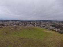 Image © thelonious


