The Modern Antiquarian
Log in
|
Register
Home
Latest Posts
Forums
Maps
Help
Browse Sites
News
Blog
Contributors
The Books
Select
-
Belgium
Denmark
Eire
France
Germany
Greece
Italy
The Netherlands
Norway
Portugal
Republic of Malta
Spain
Sweden
Switzerland
United Kingdom
Scotland
Aberdeenshire
Leys of Barras
Standing Stone / Menhir
Leys of Barras (Standing Stone / Menhir) on The Modern Antiquarian, the UK & Ireland's most popular megalithic community website. 2 images, plus information on many more ancient sites nearby and across the UK & Ireland.
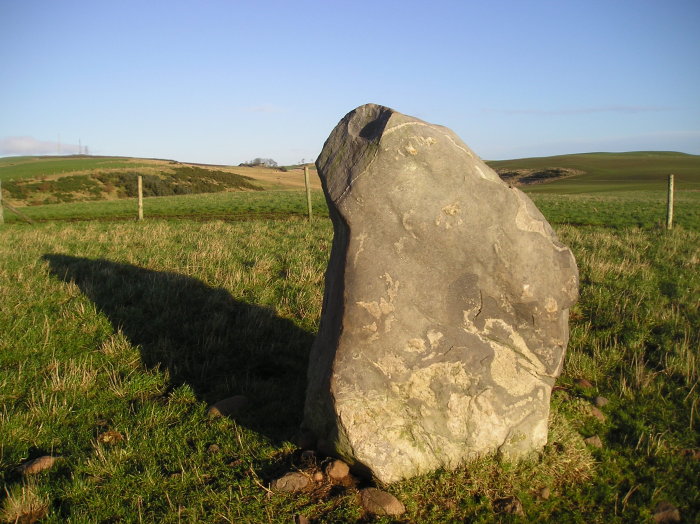
Image © tiompan
Nearest Town:
Inverbervie (6km SSE)
OS Ref (GB):
NO8203177841 /
Sheet: 45
Latitude:
56° 53' 29.72" N
Longitude:
2° 17' 41.89" W
Added by
tiompan
Images (2)
0 discussions
Start a topic
Show |
Hide
Web searches for Leys of Barras
Flickr
Google
Google Images
MAGIC
The Megalithic Portal
Bing
Stone Pages
Streetmap.co.uk
Wikipedia
Show map
(inline Google Map)
- Sites within 20 km -
-
Moray Stone (0.05km S) (6 posts)
Montgoldrum (0.54km S) (7 posts)
Montgoldrum (0.71km SSW) (5 posts)
Montgoldrum (0.73km SW) (10 posts)
Montgoldrum (0.74km SW) (4 posts)
Mitton Hill (1.44km NNE) (11 posts)
Cluseburn (1.55km S) (14 posts)
Millplough (2.44km S) (7 posts)
Millplough (2.46km S) (7 posts)
Bruxie Hill (2.7km N) (9 posts)
Hillhead (2.77km WSW) (11 posts)
Cot Hillock (3.04km SSW) (5 posts)
Castle Dykes (3.4km SSW) (4 posts)
Druidsdale (3.58km NE) (6 posts)
Blackhill Wood (4.55km WNW) (9 posts)
Bervie Brow (4.69km SE) (17 posts)
Court Stane (4.87km W) (9 posts)
Square's Knap (5.38km NNW) (5 posts)
Carmont Hill (5.85km NW) (13 posts)
Knock Hill (Glenbervie) (6.32km W) (4 posts)
Cairn Of Arthurhouse (6.64km WSW) (7 posts)
Kenshot East (6.99km SSW) (7 posts)
Gourdon Hill (7.13km S) (26 posts)
Kenshot Hill (7.36km SW) (3 posts)
Philla Cairn (7.48km SSW) (11 posts)
Droop Hill (7.5km W) (6 posts)
Haremuir (7.54km SSW) (5 posts)
Middle Knox (7.57km S) (11 posts)
Cowden (7.97km W) (5 posts)
Fetteresso Castle (8.05km N) (6 posts)
The Hawk Stone (8.05km N) (2 posts)
Fetteresso (8.1km NNE) (2 posts)
North Lodge (8.24km N) (5 posts)
Gallow Hill (Stonehaven) (8.27km NE) (9 posts)
Dunnottar Castle (8.55km NE) (15 posts)
North Shiels (8.9km SW) (3 posts)
Castle Hill (Auchenblae) (9.05km W) (3 posts)
Malcolm's Mount (9.11km NNE) (4 posts)
Dunnicaer (9.16km NE) (17 posts)
Spurryhillock (9.18km NNE) (2 posts)
Fetteresso Forest (9.39km NNW) (10 posts)
Cairn Of Shiels (9.48km SW) (17 posts)
Shiels (9.5km SW) (6 posts)
Katie's Cairn (9.64km W) (1 post)
Paul Mathew Hill (9.7km SW) (7 posts)
Barnhill (10.38km SW) (4 posts)
The Floors (10.56km S) (6 posts)
The Cloch (10.62km SSW) (10 posts)
Glenton South (10.81km N) (6 posts)
Glenton Hill (10.84km N) (5 posts)
Wood Of Mergie (10.92km NW) (3 posts)
Glenton North (11.02km NNW) (6 posts)
Bridgeton Hill Cairn (11.12km SSW) (12 posts)
Houff Of Ury (11.53km NNE) (6 posts)
Findlayston (11.64km NNE) (7 posts)
Hobseat (11.69km WNW) (0 posts)
Garvock Hill (11.77km SW) (8 posts)
Ury North Lodge (11.85km NNE) (4 posts)
Tower Of Johnston (12.24km SW) (13 posts)
Smart's Cairn (12.62km WSW) (6 posts)
Raedykes (12.79km N) (48 posts)
Kempstone Hill (12.9km NNE) (19 posts)
Auquhollie Stone (12.94km N) (14 posts)
Kempstone Hill Cairn (12.98km NNE) (5 posts)
West Bradieston (12.98km SW) (7 posts)
Bradieston (13.38km SW) (11 posts)
Allochie (13.51km NNE) (5 posts)
Strathfinella Hill (13.68km WSW) (7 posts)
Cantlayhills (13.79km NNE) (15 posts)
Elsick Mounth (14.25km NNW) (6 posts)
Cairn-Mon-Earn (14.58km NW) (21 posts)
Northward (14.77km NNW) (15 posts)
Castle Rock of Muchalls (15.01km NE) (4 posts)
Kerloch Hill (15.9km WNW) (18 posts)
The Ring (16.1km WSW) (4 posts)
Westerton (16.24km WNW) (5 posts)
The Sutor's Mither (16.41km WNW) (0 posts)
Mulloch Hill (Strachan) (16.47km WNW) (6 posts)
Nine Stanes (16.49km WNW) (72 posts)
St Ringan's Cairn (16.56km W) (5 posts)
Blarourie Ring Cairn (16.71km WNW) (10 posts)
Canterland (16.88km SW) (8 posts)
Morphie (16.95km SW) (8 posts)
Fettercairn House (16.96km WSW) (9 posts)
Fettercairn (17.01km WSW) (9 posts)
Blarourie (17.07km WNW) (7 posts)
Esslie the Greater (17.16km WNW) (52 posts)
Clune Hill (17.22km NNW) (36 posts)
West Brachmont (17.22km NNW) (5 posts)
Cairn O' Mount 2 (17.23km W) (4 posts)
Clune Wood (17.26km NNW) (3 posts)
Esslie the Lesser (17.28km WNW) (25 posts)
Clune Wood (17.28km NNW) (7 posts)
Cairn O' Mount (17.29km W) (19 posts)
Clune Wood (17.37km NNW) (11 posts)
Cairnfauld (17.52km NW) (8 posts)
Cairnshee Woods (17.72km NW) (9 posts)
Hatton (17.81km WSW) (1 post)
Balmakewan (18.19km WSW) (5 posts)
Stone of Morphie (18.37km SW) (20 posts)
Kirkton Wood (18.41km NW) (6 posts)
Upper Balfour 3 (18.44km NNW) (6 posts)
Upper Balfour 4 (18.46km NNW) (6 posts)
Upper Balfour 2 (18.47km NNW) (4 posts)
Upper Balfour (18.48km NNW) (4 posts)
Whiteside (18.57km NNE) (6 posts)
Fountain Hillock (18.95km WSW) (11 posts)
Tilquhillie (18.98km WNW) (11 posts)
Stranog Hill 1 (19.29km NNE) (4 posts)
Stranog Hill 2 (19.37km NNE) (3 posts)
Hilton of Cairngrassie (19.41km NNE) (10 posts)
Green Cairn (19.43km WSW) (11 posts)
The Knappach (19.76km WNW) (6 posts)
Knappach East (19.77km NW) (4 posts)
Knappach West (19.78km WNW) (5 posts)
The Shields (19.8km NNE) (6 posts)
Standingstones (19.82km N) (6 posts)
Standingstones Kerb Cairn (19.86km N) (2 posts)
- Add -
-
Add news
Add an image
Add fieldnotes
Add folklore
Add miscellaneous
Add a link
-
Add a site
Add a nearby facility
Add an alternative name/spelling
Images
(click to view fullsize)
Add an image
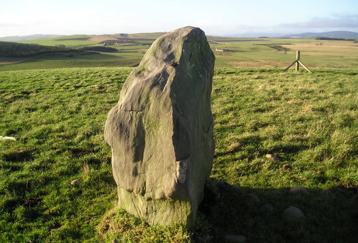
 Image © tiompan