The Modern Antiquarian
Log in
|
Register
Home
Latest Posts
Forums
Maps
Help
Browse Sites
News
Blog
Contributors
The Books
Select
-
Belgium
Denmark
Eire
France
Germany
Greece
Italy
The Netherlands
Norway
Portugal
Republic of Malta
Spain
Sweden
Switzerland
United Kingdom
County Offaly
Shanballynakill
Standing Stone / Menhir
Shanballynakill (Standing Stone / Menhir) on The Modern Antiquarian, the UK & Ireland's most popular megalithic community website. 2 images, 1 fieldnote, plus information on many more ancient sites nearby and across the UK & Ireland.
Image © Alan Lee
Nearest Town:
Tullamore (15km ESE)
OS Ref (IE):
N220348 /
Sheet: 48
Latitude:
53° 21' 46.65" N
Longitude:
7° 40' 10.21" W
Added by
FourWinds
Images (2)
Fieldnotes (1)
0 discussions
Start a topic
Show |
Hide
Web searches for Shanballynakill
Flickr
Google
Google Images
The Megalithic Portal
Bing
Stone Pages
Wikipedia
Show map
(inline Google Map)
- Sites within 20 km -
-
Greenville or Garryduff (0.92km SSE) (7 posts)
Moorock (3.88km SW) (0 posts)
Ballycumber (4.07km S) (1 post)
Cartron Glebe (5.94km NNE) (0 posts)
Castletown (6.1km S) (4 posts)
Knockdommy (7.37km WNW) (0 posts)
Corgarve (8.55km NE) (0 posts)
Ballycloghduff (8.99km NW) (5 posts)
Lemanaghan (9.14km SW) (2 posts)
Lemanaghan 2 (9.17km SW) (2 posts)
Moyvoughly (9.23km NW) (1 post)
Loughaun (9.93km E) (0 posts)
Mullenmeehan (12.56km NNW) (0 posts)
Snimnagorta (12.86km NNW) (0 posts)
Clonaglin (13.55km ENE) (0 posts)
Kileen (14.25km NE) (0 posts)
Garryduff Barrow (14.35km ENE) (0 posts)
Drumraney (14.59km NW) (0 posts)
St. Brigid's Well (14.76km NNE) (2 posts)
Rathskeagh Upper (14.92km N) (0 posts)
Lalistown (14.92km NE) (0 posts)
Aill na Mireann (15.35km NNE) (8 posts)
Kellybrook (15.4km NNE) (0 posts)
Ushnagh Hill (15.45km NNE) (1 post)
Ushnagh Hill (15.45km NNE) (2 posts)
Lalistown/Rathnew (15.59km NNE) (0 posts)
Taghboyne (15.83km NE) (0 posts)
Ushnagh Hill (15.84km NNE) (0 posts)
Hill of Uisneach Cairn (15.84km NNE) (5 posts)
Rathnew (15.85km NNE) (7 posts)
Mweelra (16.11km NNE) (2 posts)
Glomerstown (16.25km NE) (0 posts)
Lilliput (16.7km ENE) (0 posts)
Cappaghjuan (16.86km NNE) (3 posts)
Broughal (17.68km SSW) (4 posts)
Cappanrush (17.78km E) (0 posts)
Ballymorin (18.28km NNE) (4 posts)
Clonfinlough Stone (18.35km WSW) (14 posts)
Montrath (18.74km E) (0 posts)
Loughan (19.2km NNE) (5 posts)
Rathdrum (19.63km E) (3 posts)
Derrygrogan Big (19.72km E) (0 posts)
Kileenmore (19.95km ESE) (9 posts)
- Add -
-
Add news
Add an image
Add fieldnotes
Add folklore
Add miscellaneous
Add a link
-
Add a site
Add a nearby facility
Add an alternative name/spelling
Images
(click to view fullsize)
Add an image
Fieldnotes
Add fieldnotes
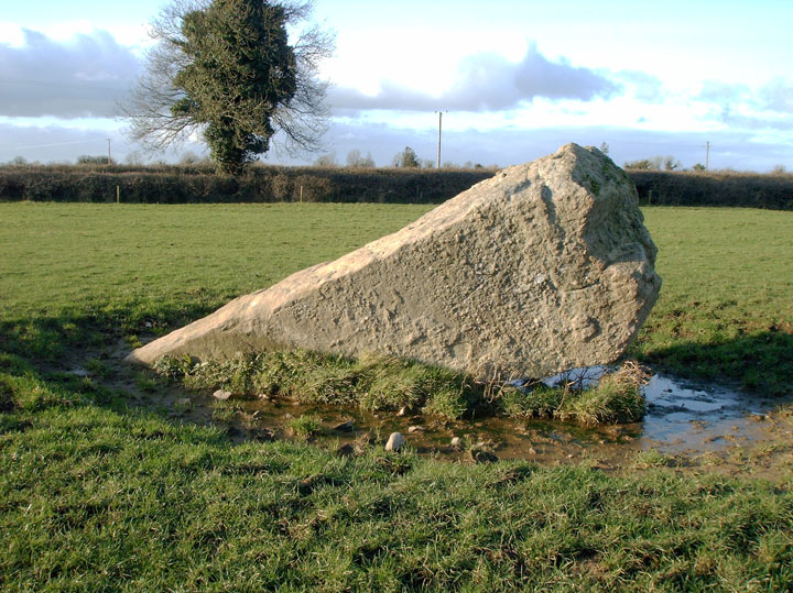
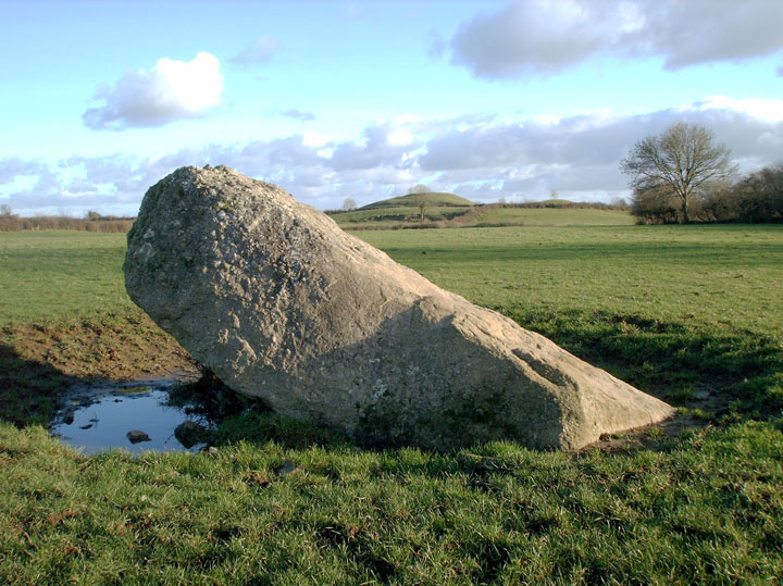
This fine Menhir has sadly fallen over. It would have stood over 3m when erect. Looks like it toppled only in recent years. It's shameful to see our national monuments suffering such neglect...
Comments (0)
|
Add a comment
|
Permalink
Posted by
Alan Lee
25th January 2007ce