stoer

stoer

Three Barrows

Walking up from Fognam, the trail runs across a series of fields running parallel to the Medieval Park Pale surrounding Ashdown; to the south in the valley bottom runs the Sugar Way, which runs from the barrow cemetery on Sugar Hill, to Hackpen Hill via Seven Barrows.

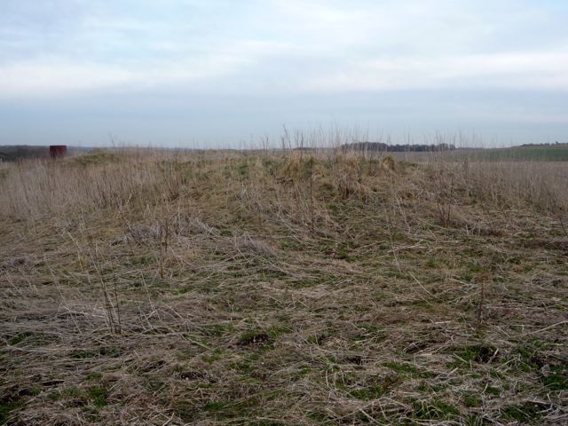
The main barrows, Three Barrows, line east-west along the north ridge of Idstone Down. Just to the north, defining the ridge is an earthwork running east-west which is contemporaneous with the development of the barrow cemetery. There are additional barrows noted in Pastscape as crop markings and also further down the hill.

The barrows are quite exposed, the weather this evening having a strong windchill; usually in this area you can also see one of the large herds of Fallow Deer which are part of the Ashdown Estate.

Image of Hardwell Camp (Hillfort) by stoer

Hardwell Camp

Hillfort

Along the western bank there seems to be Greensand dry walls possibly later date to reinforce hollow way along western bank.

Image credit: © Pete Wayne 2010

East Garston Ditch

The ditch varies from less than 1m deep to approximately 1.5m deep.
The feature sinuously runs towards the ridge and at the northern extent finishes at the ‘7’ furlong marker alongside the fenceline. From the ground feature it would seem that this did continue into the field, but ploughing has removed all trace.
The downland here is very open and gives 360 degree views of rolling chalk hills.
Before leaving I repeated dowsing the feature, as I had done at various points along the ditch; I leave it to others to determine what response you see.

East Garston Ditch

Living locally and having seen this entry lacking for a long time I decided to tab out onto the Wessex Downland and see what I could find.
Looking at the OS 1:25000 map there was an intersection between a footpath and the feature so heading out from Jimmies Farm I soon came out onto the open downland and the “scars” of the horse gallops.
Finding the required footpath, I tabbed across the gallop; the feature is very obvious in the landscape due to the rough grass that is uncut compared to the gallops.
Looking south from the intersection, the feature becomes less clear and according to the map and Pastscape the feature ends in a series of banks which have been identified as later post-Medieval sheep compounds.
Looking north from here, the ditch can be clearly seen as a north-south running feature with an easterly bank which is higher, and better preserved, than the westerly bank, which seems to have suffered more erosion.

Image of East Garston Ditch (Dyke) by stoer

East Garston Ditch

Dyke

East Garston Ditch at the northern end disappears probably due to the plough. The linear feature runs roughly north-south with the eastern bank higher than the western bank. Ditch depth is variable along the length from

Image credit: © Pete Wayne 2010
Image of East Garston Ditch (Dyke) by stoer

East Garston Ditch

Dyke

East Garston Ditch at the northern end looking south. The linear feature runs roughly north-south with the eastern bank higher than the western bank. Ditch depth is variable along the length from

Image credit: © Pete Wayne 2010
Image of East Garston Ditch (Dyke) by stoer

East Garston Ditch

Dyke

East Garston Ditch at the northern end. The linear feature runs roughly north-south with the eastern bank higher than the western bank. Ditch depth is variable along the length from

Image credit: © Pete Wayne 2010
Image of East Garston Ditch (Dyke) by stoer

East Garston Ditch

Dyke

East Garston Ditch where the footpath crosses the feature looking south. The linear feature runs roughly north-south with the eastern bank higher than the western bank. Ditch depth is variable along the length from

Image credit: © Pete Wayne 2010
Image of East Garston Ditch (Dyke) by stoer

East Garston Ditch

Dyke

East Garston Ditch looking south from the high point. The linear feature runs roughly north-south with the eastern bank higher than the western bank. Ditch depth is variable along the length from

Image credit: © Pete Wayne 2010
Image of East Garston Ditch (Dyke) by stoer

East Garston Ditch

Dyke

Looking north along the East Garston Ditch. The linear feature runs roughly north-south with the eastern bank higher than the western bank. Ditch depth is variable along the length from

Image credit: © Pete Wayne 2010
Image of East Garston Ditch (Dyke) by stoer

East Garston Ditch

Dyke

East Garston Ditch at the 4 furlong marker. The linear feature runs roughly north-south with the eastern bank higher than the western bank. Ditch depth is variable along the length from

Image credit: © Pete Wayne 2010
Image of East Garston Ditch (Dyke) by stoer

East Garston Ditch

Dyke

East Garston Ditch. The linear feature runs roughly north-south with the eastern bank higher than the western bank. Ditch depth is variable along the length from

Image credit: © Pete Wayne 2010
Image of East Garston Ditch (Dyke) by stoer

East Garston Ditch

Dyke

East Garston Ditch at the point where the footpath crosses the feature. The linear feature runs roughly north-south with the eastern bank higher than the western bank. Ditch depth is variable along the length from

Image credit: © Pete Wayne 2010
Image of East Garston Ditch (Dyke) by stoer

East Garston Ditch

Dyke

East Garston Ditch at the 5 furlong marker. The linear feature runs roughly north-south with the eastern bank higher than the western bank. Ditch depth is variable along the length from

Image credit: © Pete Wayne 2010

Miscellaneous

Lambourn Sevenbarrows
Barrow / Cairn Cemetery

It should be noted that the Seven Barrows area is probably more extensive than noted here. Surveys conducted around Lambourn have shown that there are significant numbers of barrow types extending northwards from Lambourn along the Wantage Road on both sides of the valley (these can be seen in the Google Earth images as cropmarks). It would seem that the valley that goes from Lambourn and out to Seven Barrows was a major cemetery.

Culbokie

This henge is situated at the top of a field overlooking the inner Cromarty Firth. The earthworks are well preserved and the ditch and bank can be traced easily.

Speaking with the old farmer, many years ago, who owned the land, there used to be a stone avenue that led off from the henge down the hillside towards the water. From what I recall the avenue wasn’t complete but included a “fair number” of stones. The orientation would have been towards the west looking at Ben Wyvis. He remembered helping his father pull them out and they were discarded in the area; it should be noted the small greenlane that follows the fields near to the henge had many big stones along the boundary.

Folklore

Ashdown Park Sarsens
Natural Rock Feature

Legend has it that Merlin the greatest Magician Britain has ever known, wandered through the Wessex Downland and in a moment of madness turned a flock of sheep to stone......these are now seen as the sarsen field below Kingstone Down.

Folklore

Ashbury
Holed Stone

There is a tale that behind St Mary’s Church stood a stone circle and some of the stones are still to be found scattered on the field boundary. Another tale suggests the stone circle encircled the old village much like the stones at Avebury.

Incidentally there is a lovely sunken holloway (funeral path?) that runs from the bottom of Ashbury Hill (SU26708498) westwards around the back of St Mary’s Church (and over the old stone circle?).

Folklore

Alfred’s Castle
Hillfort

The “Dragon”, or “Michael” Line passes through the earthen banks and on through Ashbury House. There is a tale that the house was deliberately built on the energy line for the “good masculine energies”.