


Friday 28/11/03
Another site which I have visited, passed by and played around as a kid on countless occasions, but never got round to writing fieldnotes or taking piccies until now. Plus, many times I’ve passed by with my camera in the summer the front of the well has been sealed off (to prevent folk drinking the water which gets full of algae in the heat of the summer). Well, the summer has definitely long gone and the iron shutters are off allowing you to see into the mini-vaulted roof of this well through the black grill. The water flows from a spout built into the main supporting pillar of the roof. The whole structure has a certain flowing feel to it due to the black railing which curve round both sides of the well house.
Details and pictures from the excellent Border Stones website
In 1965 two inscribed stones were placed at the well by the resident of Camp Shiel. One bears a thistle motif, whilst the other is inscribed ‘Cheese Well 1965’.
Tradition has it that travellers crossing the Minch Moor should leave pieces of food (cheese prefered!) for the little people to ensure a safe passage across the moor (which can be a bloody cold and bleak place at times so get yer sandwiches out for the wee folk!!)
The entry in the Border Stones database


16/11/03- southern side with the peak of Lee Pen just visible through the trees


16/11/03- with the blot-on-the-landscape that is the Cardrona Hotel in the background
Sunday 16/11/03
This is one of those sites which I have been meaning to visit for ages, but somehow, I’ve never got round to it. The position of the stone is (was) great (now the view west is marred by the blot-on-the-landscape that is the Cardrona Hotel, plus it stands at the entrance to the new Cardrona village- a disgusting housing scheme for those with more money than taste). To the south is Cardrona forest, the north is the forest of Glentress and to the east the hills of Lee Burn and Lee Pen. The stone itself is around 1.3 metres high and approximately 1.8 metres in girth. It’s now leaning to the north. CANMORE notes that it sits on the crest of a scarp representing the ancient course of the River Tweed, so it would have originally been right next to the water, but now is around 100 metres away.

15/11/03- the stone at the southern edge of the wall


Saturday 15/11/03
The firetrack next to the settlement is a section of the climb up to some excellent DH biking in this forest. I’ve passed the clearing on many occasions, known about the settlement from the OS map, but never connected the two. On climbing down from the track I notice a wooden post at a corner where the trees stop with the letter ‘S’ on it. Having a look around I can just see in the trees one of these at each corner of the clearing. Looks like FC marked this area out when they planted the forest. From the track you can see the outline of the external wall, but most of this has collapsed down the steep sides of the hill and into the forest. I could only find one stone on the southern flanks (although CANMORE mention three). There are also meant to be eight house platforms within the wall, but these are very difficult to distinguish due to the overgrown vegetation. The occupants of this place must have had an excellent view up and down the Leithen Water and across to Lee Pen, though the position is not a defensive one, unlike the two forts (the Pirn and Caerlee) only a couple of kilometres or so down the glen.
From the Imperial Gazetteer of Scotland, 1868;
The spa does not appear to have been remarked for its medicinal properties till about the commencement of the present century. Till then it was noted chiefly or altogether as the resort of pigeons from the circumjacent country, and bore the name of the Doo-well. Had any saint in the Romish calendar been acquainted with it, the priests of the age preceding the Reformation would have pictured him to their gullible flocks as performing a far different exploit in connexion with its waters, than that which Meg Dods ascribes to the patron saint of ‘the Aulton’ in reference to St. Ronan’s Well, and would hardly have failed to send down to posterity the fame of miracles achieved by the naturally salutiferous properties of its waters. Even after it came into late notice, the well was a trivial, repulsive-looking fountain, bubbling up amidst a little marsh; and had no better appliance than a rude bench placed at its side for the accommodation of the infirm invalids who crept or were carried to it in quest of health. A simple pump afterwards rose gauntly from its mouth, amidst the wet miry puddle around it. But about 35 years ago, or not much earlier, the spa, with remarkable suddenness, and in a way nearly unaccountable, became celebritous among valetudinarians of all classes in Edinburgh and throughout the south of Scotland. The well, in the decorations built over and around it, in the character assigned it by popular opinion, and in the influence it exerted on the village in its vicinity, now rose, as if by magic, from the status of a watery hole in a quagmire, to that of an infant competitor with the proud spas of England. In 1824, the publication of Sir Walter Scott’s tale of St. Ronan’s Well, greatly enhanced its celebrity, and poured down upon it some rays of that lustre which popular opinion then assigned to ‘the Great Unknown;’ for nearly all the readers of light literature, in spite of the utter difficulty which a topographist would have felt to discover resemblances, unhesitatingly identified the Marchthorn and the St. Ronan’s of the tale with Peebles and Innerleithen. The well springs up at the base of the Lee-pen, about 200 feet above the village. In its original state, it issued in small quantities, and at only one spring; but, when the ground was dug to its source, in order to clear away admixtures near the surface, it became emitted in two streams of different strength. On analysis, a quart of the less impregnated stream was found to contain 5.3 grains of carbonate of magnesia, 9.5 grains of muriate of lime, 21.2 grains of muriate of soda,--in all, 36 grains; and a quart of the other stream, 10.2 grains of carbonate of magnesia, 19.4 of muriate of lime, and 31 of muriate of soda,--in all. 60.6 grains. The waters, jointly with the salubrious influence of the fine climate, are efficacious chiefly in cases of ophthalmic complaints, old wounds, and dyspeptic and bilious disorders.
Description and directions
Description, directions and opening times
Article about the modern stone carvings
Description, references etc
Description and directions


2/11/03- front view on modern plinth in front of Innerleithen Parish Church

2/11/03- close up of modern plinth inscription

Sunday 2/11/03
This site is usually described as a ‘runic cross’. There are no runes on it and neither is it a cross. It’s a cup and joined-ring marked stone almost 1 metre high and oblong in section. It sits on a modern engraved sandstone plinth dwarfed by the church immediately behind it (one of my friends has the original plinth as a feature in his extensive gardens!). The cup and ring markings are executed in the classic style- by a pecking technique which makes me think that this stone is somewhat much older than the proposed 8th century- the design certainly is. All four sides of the stone are decorated with the same pattern. I can’t find any evidence to suggest that this stone actually formed part of a cross- I guess it was assumed so as it was found in the foundations of an old church which used to stand on this site. However- how many churches have been built on top of Neolithic or Bronze Age monuments?


2/11/03-the well house frontage showing the two towers either side of the main wellhouse and the coat of arms

From the NSA 1845;
‘This mineral spring was formerly called the ‘Dow-well’, its water is now recognised as curative and it is resorted to by many visitors. Had it been known in ancient times as a medicinal water, without doubt the clergy would have taken advantage of that fact and dedicated it to some saint.‘
As indeed they did- and it now bears the name of St. Ronan.
Sunday 2/11/03
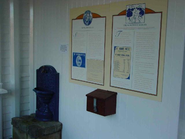
A more grand and glorious well house would be hard to imagine- resplendent in the St. Ronan’s colours of sky-blue and white with a huge royal coat of arms and flagpole. Unfortunately the well house closes for the season on the 19th October, however, on the veranda you can still partake of the mineral waters from a cast iron cistern built into the wall. There are also a couple of interpretive panels highlighting the connections with Robert Burns and Sir Walter Scott. The spa house was built in 1827, but the curative mineral water of the wells must have been a magnet for thousands of years.
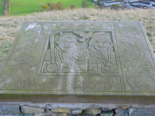
2/11/03- the eight and final stone plaque showing the Cleikum festival and ceremony

2/11/03- the seventh of the stone plaques showing the history of the surrounding land- the mills

2/11/03- the fifth of the stone plaques on the hillfort showing life from ancient to modrn times- the Victorian era and the coming of steam

2/11/03- the fourth of the stone plaques- coming of agriculture, cup and ring marks from the stone at the Parish Church and the Salmon of Knowledge

2/11/03- the third of the stone plaques representing local history- the old wild animals of Scotland- the bear, the wolf and the wild boar.

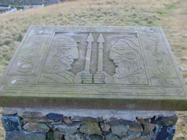
2/11/03- the second of the stone plaques representing the history around the fort- the Scots
2/11/03- the first of the stone plaques on the summit of the fort (which are laid out in a ring to represent one of the house circles that would have stood here)- the Picts and the Romans

2/11/03- from Caerlee Hill Fort over the other side of the Leithen Water glen

2/11/03-the hill fort slap bang in the middle of the pic and commanding a view over Innerleithen
Sunday 2/11/03
The usual way across the Leithen Water is blocked- the 18th Century Cuddy Brig is finally being restored before the whole thing collapses into the water. I wander up to Jenny Bapties Well and cross the water by the old stepping-stones. A short climb takes you to the summit of this hill, though on the way very little remains of the fortifications can be seen which used to guard this place. There’s a great view across the town of Innerleithen and up and down the Tweed Valley and across to Caerlee Hill Fort on the other side of this glen. The twenty or so house platforms are difficult to see due to the thick ungrazed grass which covers the fort. There’s a fantastic modern addition though in the shape of six carved stone plaques depicting life in Innerleithen from early times to the present day (including a beautifully executed salmon).


From the RCAHMS 1967;
Excavations carried out in the 19th c somewhere in the part of the settlement that lies to the W of the boundary dykes revealed “several bronze bracelets”, one of which was of penannular form with expanded terminals (W A Chambers 1864). It is not known where these objects now are.
Sunday 2/11/03
Through St. Ronan’s Wood I follow the sight of the communications mast that now sits on the side of this fort. The fort is now split in two N/S by a dry stane dyke. On the eastern side of the wall the summit of the hill has been fairly extensively quarried and much of the ramparts and house platforms have been destroyed. However, climbing over the fence, the original features of this fortified settlement are more apparent- you can still see about four of the hut circles and most of the ramparts. From the summit there is a commanding view of the Tweed Valley and across the other side of the Leithen Water glen to the Pirn Hill Fort.